
Passive Microwave; Lidar
Although active microwave systems, i.e., radar, are the more commonly used sensors for this region of the spectrum, passive microwave sensors also have provided information about the Earth's surface, its oceans, and its atmosphere. Air- and space-borne sensors have operated for several decades. They measure directly radiation incited by thermal states in these media and hence are representative of natural phenomena inherent to the materials (hence, passive).
The principle underlying passive microwave radiation is implicit in the following spectral curves that show relative intensities of radiation (radiances) as a function of wavelength for materials with different intrinsic temperatures:
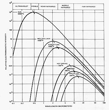
All of these curves have similar shapes, but as expected, the hotter the radiating object, the greater the intensity. Note, too, that the peaks of the curves shift systematically to the left as the objects increase in kinetic temperature. This shift is the consequence of Wien's Displacement Law that we examine in more detail in Section 9 on Thermal Remote Sensing. Technically, the radiation shown above is that of blackbodies at different temperatures. Natural materials are graybodies whose temperatures depart somewhat from perfect blackbodies. The important point here is that there is radiation from thermal bodies even at longer wavelengths (right part of the curves and beyond) that extend into the microwave region. This radiation, which is emissive, is generally much weaker in intensity compared with shorter wavelength outputs but is still detectable by sensitive instruments and also is not much attenuated by the atmosphere. The temperatures measured by these instruments are brightness temperatures. . In this family of curves, land, water, air, and ice have different brightness temperatures and thus we can separate them in many cases, and sometimes uniquely identify them.
The wavelength segment of the blackbody curves employed in passive microwave detectors is generally between 0.15 and 30 cm. In frequency units (the normal way to express a radiation interval), this interval translates to a range between 1 and 200 GHz. Frequencies we most commonly use center on 1, 4, 6, 10, 18, 21, 37, 55, 90, 157, and 183 GHz (thus the multispectral mode is feasible), but the signal beamwidth is usually wide, in order to gather sufficient amounts of the weak radiation. The spatial resolution of the instrument also tends to be low (commonly, in kilometers from space and meters from aircraft-mounted sensors), to allow large sampling areas that provide enough radiation for ready detection. The sensors are typically radiometers that require large collection antennas (fixed or movable). On moving platforms, the fixed antenna operates along a single linear track so that it generates intensity profiles rather than images. Scanning radiometers differ by having the antenna move sidewards to produce multiple tracking lines. The result can be a swath, in which the variations in intensity, when converted to photographic gray levels, yield images that resemble those formed in visible, near-IR, and thermal-IR regions. Here is an example:
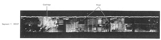
From T.M. Lillesand and R.W. Kieffer, Remote Sensing and Image Interpretation, 2nd Ed., © 1987. Reproduced by permission of J. Wiley & Sons, New York.
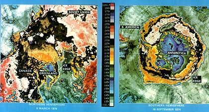
On land, passive microwave surveys are particularly effective for detecting soil moisture and temperature, because of sensitivity to water. Microwave radiation from below thin soil (overburden) cover indicates near-surface bedrock geology. Assessing snow melt conditions is another use. Tracking sea ice distribution and conditions is a prime oceanographic application. Another marine use is for assessing sea surface temperature. Passive microwave sensors are important components on some meteorological satellites, being well suited to obtain temperature profiles through the atmosphere, as well as water vapor and ozone distributions and precipitation conditions. We describe the ESMR and SMMR scanning microwave radiometers flown on Nimbus metsats in Section 14. Here is an ESMR (Electronically Scanned Microwave Radiometer), single band (19.3 GHz) image received from the Nimbus 5 metsat that provided sea ice data for both polar regions. Open water appears in gray-green tones.
Another active sensor system, similar in some respects to radar, is lidar (light detection and ranging). A lidar transmits coherent laser light, at various visible or NIR (Near-IR) wavelengths, as a series of pulses (100s per second) to the surface, from which some of the light reflects. Travel times for the round-trip are the measured parameter. We can operate lidar instruments as profiliers and as scanners, day and night. Lidar can serve either as a ranging device to determine altitudes (topography mapping) or as a particle analyzer for air. Light penetrates certain targets, so that one prime use is to assess tree canopy conditions. Returns are obtained from tree tops, from within the trees, and from the ground, as shown in this diagram:
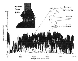
We can interpret these data to indicate the amount of biomass associated mainly with the leaves. This information is important in determining the global condition of vegetation that governs production of CO2 and O2, key factors in sustaining life, and now a great concern because deforestation in the tropics and temperate zones depletes these gaseous resources.
Lidar can also penetrate shallow water bodies to give information (usually as profiles) on water depths. The difference in time delay between returns from the surface and from the water bottom (from which returns will be weaker) indicates the thickness (depth) of the water column at any point.
Certain lidar wavelengths cause materials to fluoresce (emit light radiation at different wavelengths than that of the incoming beam), which tuned detectors can pick out. Oil slicks respond in this way, and chlorophyll in sealife also fluoresces.
Lidar operates normally from aircraft platforms but a spaceborne sensor (LITE, for Light In-space Technology Experiment) was flown on the Shuttle in 1994. It monitored clouds and measured atmospheric particles. Another instrument, the Vegetation Canopy Lidar, will fly on the first of a series of low-cost satellite missions in NASA's new Earth System Science Pathfinder (ESSP) program. A laser altimeter (GLAS) remains one of the sensors to launch (around 2002) in the EOS series (see Section 16).
We have come to the end of this Section, hoping that you have come to the realization that the microwave region of the spectrum can do many useful things, besides cook your food. Radar, in particular, is now a mainstay for both civilian and military space observations, being invaluable because of its independence from most weather conditions. As experience is gained, we are learning how to conduct feature classifications offering much the same information content as extracted from Visible and Near-IR imagery. Next, we need to become acquainted with the power of thermal remote sensing for identifying classes on the ground and conditions in the oceans.

Collaborators: Code 935 NASA GSFC, GST, USAF Academy
Contributor Information
Last Updated: September '99
Webmaster: Bill Dickinson Jr.
Site Curator: Nannette Fekete
Please direct any comments to rstweb@gst.com.