 |
|---|
 |
| Plate P-11 |
| Plate P-11A |
|
|---|
|
| Plate P-11 |
| Plate P-11A |
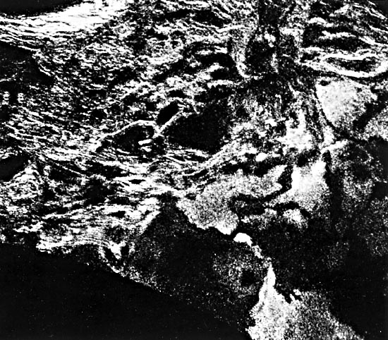
The high-resolution views of the Venusian surface on the next pair of pages have been obtained through the optically opaque atmosphere by radio telescopes at Arecibo, Puerto Rico, and Goldstone, California (Plate P-11, left), and by the Soviet Venera 15 and 16 spacecraft (Plate P-11, right). The highest resolution on these images ranges from 1 to 4 km. More important, however, is the radar incidence angle. Near-vertical incidence images, such as those from Venera 15 and 16 (5 to 15°) are sensitive to edges and small slopes, whereas higher angles(15 to 65°) are most sensitive to small-scale roughness that may be landform-specific. The left view of Plate P-11 (Arecibo radar) shows the Maxwell Montes region (Figure P-10.1) with 2-km resolution at a 65° incidence, resulting from Maxwell´s 65°N latitude.
The banding of the Maxwell area, which has been the subject of much study (Campbell et al., 1983), may result from either extensional or compressional tectonism. Compression on Earth produces features such as fold belts and imbricate thrusts that might be analogous to the Maxwell banded terrain. Another possibility would appear to be flow structure resulting from very silicic lavas that, because of their high viscosity, frequently form ridges normal to the flow direction. However, these bands are 10 to 20 km wide (Campbell et al., 1983), far larger than any terrestrial analog.
The right image of Plate P-11, from Venera 15 and 16, shows a much larger area centered on Maxwell, with a 10° incidence angle (Barsukov et al., 1985). The circular crater shown on both views is Cleopatra Patera. Originally interpreted as a large caldera, it has more recently been proposed to be a multi-ringed impact crater with a central peak.
| Figure P-11.1 | Figure P-11.3 |
|---|---|
 |  |
The currently favored model for the geologic evolution of this region calls for a complex multistage history involving tectonism (uplift, extension, compression), volcanism, and minor erosion. The physiography and great relief of Maxwell make it one of the most interesting regions on Venus, but it may be an unusual feature from a global viewpoint. Examples of more representative landforms and terrains are presented in Figures P-11.1 through P-11.4.
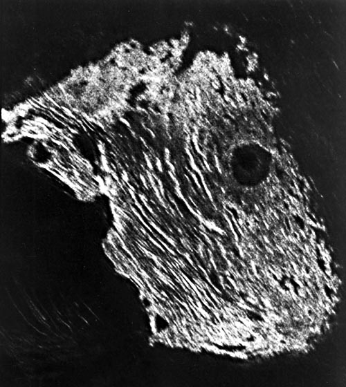
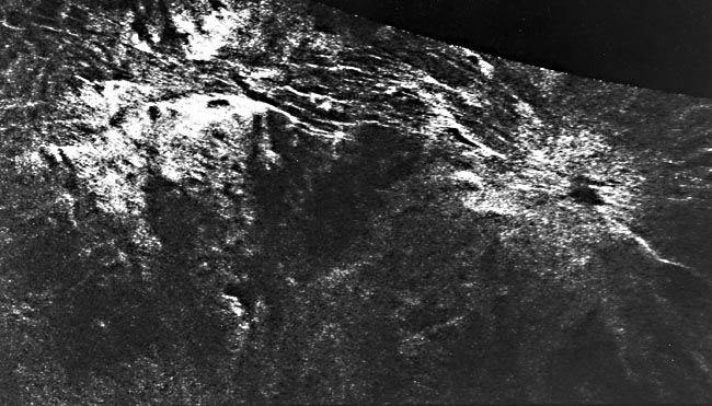
There is evidence that volcanic processes have operated on Venus as they have on other bodies. Figure P-11.1 is an Arecibo radar image of the summit region of Beta Regio. Beta has been interpreted as a large volcanic complex, including a shield structure (Theia Mons, at bottom), a rift zone, and another volcanic edifice (Rhea Mons, bright feature at top right). It may be analogous to the East African rift zone and associated volcanics. The flow-like features coming from Theia Mons are similar in dimensions to terrestrial volcanic flows. Other evidence for volcanism on Venus can be seen on the plains in an Arecibo image (Figure P-11.2) of the area southeast of Lakshmi Plateau that shows what appear to be volcanic flows and source vents. Comparable features have also been identified on the Lakshmi Plateau itself (Plate P-11, right image).
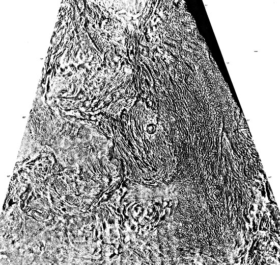
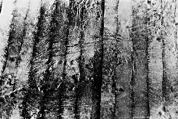
In addition to unambiguous volcanic features, the higher plains of Venus commonly display a type of intensely lineated or banded terrain termed "parquet" by Soviet scientists because of its resemblance to certain types of wood flooring. The term "tessera" has since been adopted by the International Astronomical Union. Figure P-11.3, a Venera mosaic covering an area 600 by 850 km near Ishtar Terra, shows a large area of parquet terrain (using the original term). Several different terrestrial analogs for this terrain have been suggested, including Cenozoic folds such as the Sulaiman Range in Pakistan (Plate T-45) and midocean ridge-transform fault systems such as those in the eastern Pacific. Silicic lava flow structures have also been proposed, but as for those near Maxwell, the ridges of the parquet terrain are far larger than any known lava ridges.
| Figure P-11.2 | Figure P-11.4 |
|---|---|
 |  |
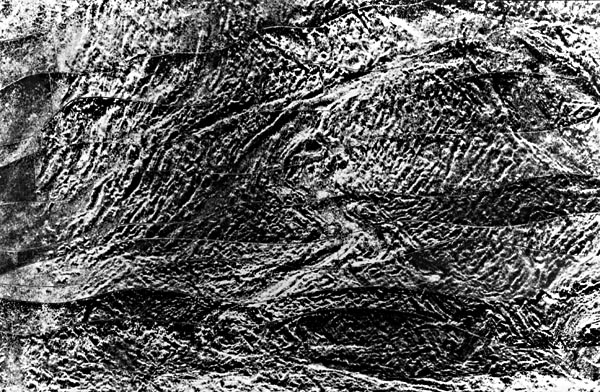
A previously unknown Venusian landform, the "coronas," was discovered by the Venera 15/16 radar, as shown in Figure P-11.4. Most coronas are 100 to 300 km in diameter and are composed of concentric systems of faults or ridges. Like so many Venusian features, their origin is not understood, opinion being divided. They resemble the fracture patterns associated with large plutons on the Earth; the individual intrusions making up batholiths sometimes display structures of this type. The gross outline of the coronas is reminiscent of multiringed impact features. They might represent the Venus analog of modified impact features such as the Sudbury Basin of Ontario, in which intrusions and volcanism might have deformed the original crater to produce a corona. Still another view is that the coronas represent relaxed volcanic centers. Given the high temperatures at the surface of Venus, old (1 to 2 billion years) volcanic constructs could collapse by creep, leaving behind some type of corona structure.
Without subkilometer resolution radar images of these ambiguous features, conclusive statements about their origin must be deferred, presumably until 1988 when the Venus Radar Mapper (Magellan) arrives. At this point, it is certain that Venus, having a wide range of volcanic, tectonic, impact, and composite features, is more geographically diverse than the Moon and perhaps even Mars. Left: Arecibo Observatory; right: U.S.S.R. Academy of Sciences.
Continue to Plate P-12| Chapter 10 Table of Contents.| Return to Home Page| Complete Table of Contents|