 |
 |
|---|---|
| Plate T-15 | Map |
|
|
|---|---|
| Plate T-15 | Map |
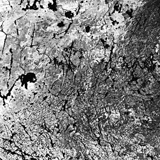
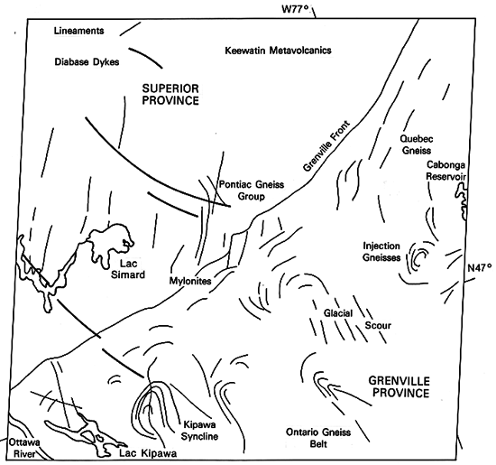
This scene boldly portrays the fault-controlled boundary between the oldest (Superior) and youngest (Grenville) structural provinces of the Canadian Shield. When viewed regionally, the two provinces differ in the number (density) and orientation of megalineaments, and as revealed here, the tectonic zone of contact between them appears to show its own characteristic fracture patterns. Prominent megalineaments in the Superior Province trend north-northeast, and those of the Grenville trend north-northwest. Both sets of lineaments are separated by a region with a dominant east-northeast topographic grain. Folds are indicated by the topographic patterns along the southern border of the image.
Terrain developed on the rocks of the Superior Province in this part of western Quebec is a low, nearly flat erosional plain reduced over the last 2.5 Ga by stream erosion and glaciation. Although today's surface has been strongly affected by Pleistocene glacial events, it is actually an ancient peneplain that has undergone only moderate erosion since the Superior cratonic nucleus stabilized at the close of the Archean. The relative smoothness of the surface suggests that the underlying rocks are more homogeneous in terms of resistance to erosion than those of the Grenville Province. Most rocks making up this segment of the province are igneous and medium grade (greenschist to amphibolite) metamorphic bodies derived 3.4 to 2.5 Ga ago. Supracrustal sediments (graywackes, shales, and iron formation) and volcanics were laid down in active mobile troughs or sags, many controlled by faults. In the north of this scene are metavolcanics of the Keewatin greenstone belts that probably once underlaid an island arc. Metasediments are dominant in the Pontiac Gneiss belt whose K/Ar ages of about 2.5 Ga relate them to Metamorphism accompanying the Kenoran orogeny that climaxed the history of the province.
Following this orogeny and subsequent episodic uplifts, intensive erosion for the next 600 to 700 Ma swept away great volumes of weathered material from the initially mountainous terrain. Some of this material accumulated in basins in what is presumed to be the Grenvillian basement. The Grenville Province underwent deformation and igneous intrusion during the Hudsonian orogeny (~1.8 Ga). Anorthosites were emplaced over several limited time spans centering around 1400 Ma ago. The Grenville Province assumed its present character starting about 1200 Ma ago, with orogenic climax in the interval 1050 to 950 Ma ago, which transformed the sedimentary rocks and older volcanic, intrusive, and metamorphic rocks in the region into a metamorphic assemblage that attains amphibolite to granulite facies levels, along with migmatites and new intrusive. The entire province seems to have been shoved northward against the Southern Superior, Churchill, and Nain Provinces along a vast accretionary zone along the southeast and east margins of the North American proto-continent.
In the northern part of the image, the Quebec Gneiss belt typifies the Grenville Province in structure and lithology. Near Cabonga Reservoir, a swirled body of plutonic rocks is surrounded by foliated metavolcanic and metasedimentary rocks. To the southwest, the Ontario Gneiss belt is dominantly metasedimentary. The Kipawa syncline block is a conspicuous plunging steep fold with kyanite-garnet gneisses and quartzites in the core.
| Figure T-15.1 | Figure T-15.2 |
|---|---|
 |
 |
The Grenville Front itself is a zone from 20 to 30 km wide, with increased metamorphic effects in rocks on both the Superior and Grenville sides. In places, a recognizable fault zone with mylonites -the Boundary fault- defines the actual contact. The fault varies between a high-angle reverse and a thrust that dips southeast. Elsewhere, the best evidence for the discontinuity comes from abrupt changes in metamorphic grade, with higher intensities in the Grenville Province. Foliation, as well as a number of megafractures, trends northeast.
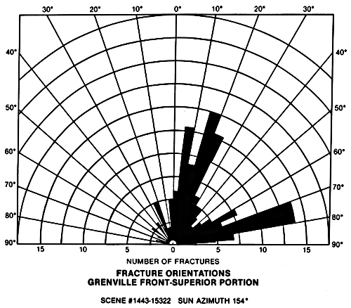
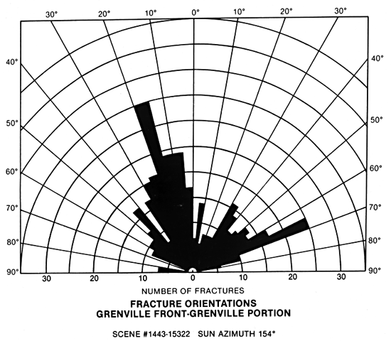
A plot of megalineament orientations (Figure T-15.1 and T-15.2) within the two principal provinces reveals significant differences. A north-northeast trend in strike characterizes Superior rocks and a north-northwest trend marks those of the Grenville. The east-northeast secondary trend noted in the two rose diagrams is associated with the boundary zone between provinces. Most visible lineaments owe their expression to glacial scouring of zones of weakness (such as close-spaced fractures), which produced depressions later filled with lakes (Figure T-15.3) (black in Landsat IR images) or bogs (darker gray).
| Figure T-15.3 | Figure T-15.4 |
|---|---|
 |
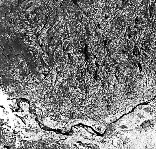 |
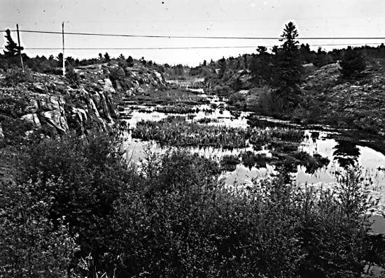
Elevations in the Grenville Province range between 350 and 650 m, with relief sometimes exceeding 150 m locally. Rounded ridges and knobs are common; these have been partially shaped by glaciation. Low areas contain glacial fill. Forests consist of maple and pine in the south that give way to spruce and fir northward. A typical Grenvillian landscape of more rugged hills is shown in Figure T-15.4, which is a Landsat-4 Thematic Mapper (TM) image of the edge of the Shield north of Ottawa, west of the Laurentian Mountains. This image is southeast of the previous Landsat images and shows how erosion has differentially etched out the folded metasediments. The fracture density in this TM scene is almost double that identifiable in a Landsat Multispectral Scanner (MSS) image, taken 7 years earlier on almost the same date, owing to the better resolution and a light dusting of snow. (NMS) References: Baer (1981), Irving and Donaldson (1972), Osborne and Morin (1962), Wynne-Edwards (1972). Landsat 1443-15322-7, October 8, 1973.
Continue to Plate T-16| Chapter 2 Table of Contents| Return to Home Page| Complete Table of Contents