 |
 |
|---|---|
| Plate T-17 | Map |
|
|
|---|---|
| Plate T-17 | Map |
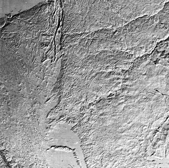
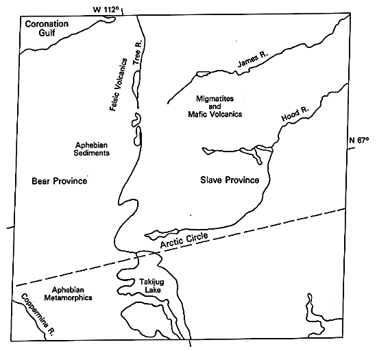
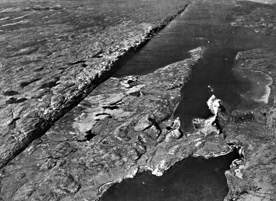
This extraordinary image convincingly conveys the value of the combination of low (winter) Sun angle (09°) and snow cover in accentuating the fracture patterns in an ancient craton or shield terrane. The scene lies athwart the Arctic Circle (hence, almost no forest) south of the Coronation Gulf, Northwest Territories of Canada, across from Victoria Island. Two of the seven major age provinces of the Canadian Shield -Bear Province (left) and Slave Province (right)- are juxtaposed along a sharp boundary (suture line?) that also stands as a topographic scarp, the result of differential erosion. These provinces differ in several respects:
1. Surface rocks in the Slave Province are mainly Archean. Isotopic ages cluster around 2500 Ma -the Kenoran orogeny that marked the end of the Archean in North America. Ages of rocks in the Bear Province average 1750 Ma -the Hudsonian orogeny.
2. As evident from the index map, rocks comprising the Slave Province represent a high grade of metamorphism, intrusion, and basement remobilization typical of Archean terranes. Many of these rocks are metamorphosed members of the sedimentary Yellowknife Supergroup. Rocks of the Bear Province are mainly metasedimentary and volcanic, deformed in the Aphebian Era. A few outliers of these Lower Proterozoic rocks remain on the Slave Province, particularly around Lake Contwayto.
3. The structural style in the Slave Province is that associated with deep crustal units. Migmatites, batholithic intrusive, and granulitic metamorphic rocks show foliation and compositional banding, but the rocks are rather uniformly hard and so thoroughly deformed that little foliation is expressed in landforms at this scale. Most Yellowknife Supergroup metasediments are tightly folded (isoclinal) or occur in plunging anticlines (see lower right corner). The Bear Province rocks are both folded and strongly foliated (approximately parallel to fold-axis trends), giving rise to a pronounced north-south grain that has a subdued but strongly linear topographic expression.
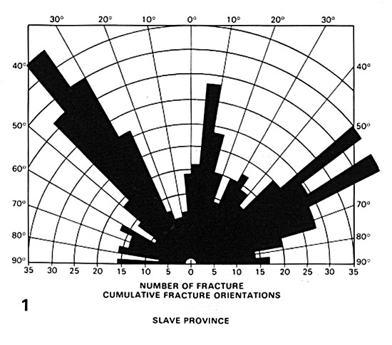
The lineaments in the Slave Province are clearly expressed because of glacial scouring which removed most of the soil cover and excavated the bedrock along lines of weakness. The density of fractures is the highest the writer has seen at this scale in Landsat imagery. Orientation measurements (Figure T-17.1) reveal three dominant directions (Lowman et al., 1986). Many lineaments can be traced for 50 km or more; where intersections are observable, offsets are rarely seen, supporting the hypothesis that these are tensional fractures without planar slip. A prominent zone of lineaments running vertically through the image center corresponds to a dike-like intrusion of metamorphosed volcanic rocks. The rose diagram for the Bear Province shows almost identical orientations (adjustments were made for the foliation trends) but much lower densities. Note the large "patch" of Archean rock along the Coronation Gulf; its identity is disclosed by its fracture density. In both provinces, the principal orientation trend is northwest; in the field, numerous younger (1100 to 1200 Ma) Proterozoic diabase dikes (not distinguishable from fractures in image) occupy lineaments of that trend.
| Figure T-17.1 | Figure T-17.2 |
|---|---|
 |
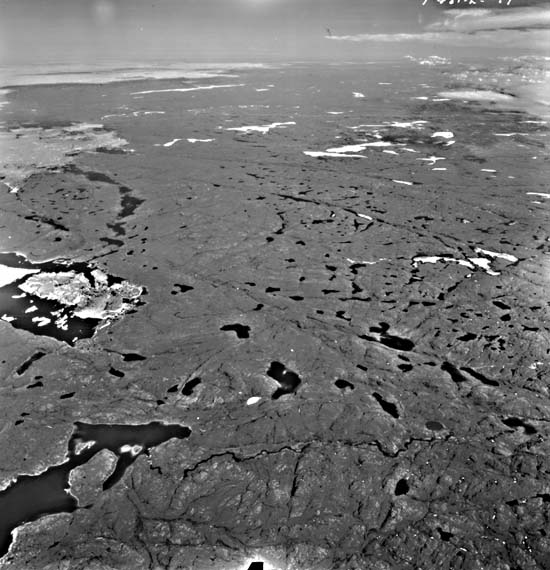 |
Both provinces have surfaces of low relief (Figure T-17.2), but the average elevation of the Slave Province is higher (up to 670 m) than the lowlands of the Bear Province (relief 100 m). The present surface is an exhumed Precambrian erosion surface (slightly modified) developed at the end of the Archean, now exposed after removal of later Aphebian and Phanerozoic cover rocks. Ridges with steep slopes are produced from resistant Late Archean diabase/gabbro intrusions along linear zones within the eastern section of the Bear Province. Erosional remnants of large sills appear as flat plate-like plateaus along the Gulf.
| Figure T-17.3 | Figure T-17.4 |
|---|---|
 |
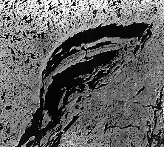 |
The southern edge of the Slave Province 600 km to the south abruptly meets the younger (1.6 Ga) Churchill Province (farther south) along the MacDonald fault, a major crustal break traceable for more than 500 km into the shield. This fault (Figure T-17.3) stands out at the surface as a conspicuous scarp more than 100 m high in places. The same scarp can be followed in a Landsat image as a bold trace, without apparent relief, along the southeast side of the Great Slave Lake (Figure T-17.4). There, most of the rocks in the Slave Province are granitic with subordinate Yellowknife metasedimentary and volcanic rocks. The rocks in the Churchill Province are also primarily granites and gneisses, but Aphebian metasediments occur in isolated patches, such as along Taltson Lake (lower right). The arc- like units within Great Slave Lake are Aphebian and Helikian (younger) basin sediments and intrusive gabbros. As is typical in glaciated shield terrain, glacial plucking has emphasized the linear fractures, and water now fills the topographic lows. (NMS) Additional References: Fraser et al. (1970), Hoffman et al. (1970), McGlynn and Henderson (1972). Landsat 1206-18381-7, February 14, 1973.
Continue to Plate T-18| Chapter 2 Table of Contents| Return to Home Page| Complete Table to Contents