 |
 |
|---|---|
| Plate T-20 | Map |
|
|
|---|---|
| Plate T-20 | Map |
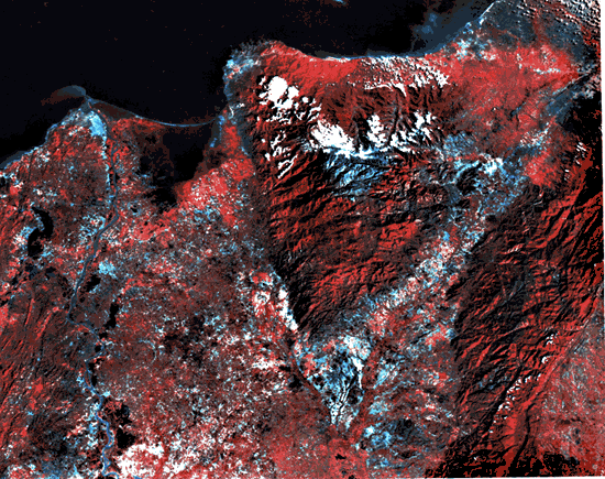
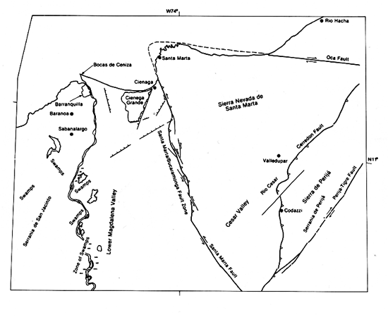
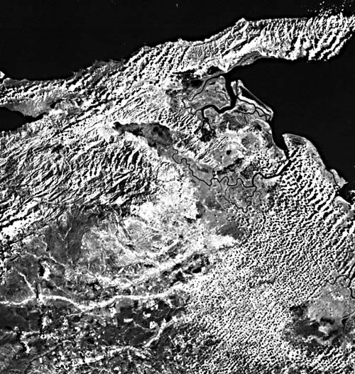
The terrain displayed in this Landsat mosaic of the northern coast of Colombia is dominated by the Sierra Nevada de Santa Marta. At 5800 m, the Sierra Nevada de Santa Marta is the highest point in Colombia, although it is immediately adjacent to the ocean. Truly an impressive feature, the Sierra is the result of recent and continuing tectonism of very huge scale. The oldest exposed rocks in the Sierra are Precambrian plutonic rocks. The remainder of the core is made up of Triassic and Jurassic plutonic, volcanic, and sedimentary rocks. The mountain mass has moved (in a relative sense) in a northwest direction so that it now sits over a portion of Carribean oceanic crust. The movement has occurred along the right-lateral Oca Fault and the left-lateral Santa Marta/Bucaramanga fault system. As readily seen in the imagery, the transition from mountainous terrain to flat lowland occurs abruptly across these two major fault systems. Behind the mountain to the southeast lies the valley of the Rio Cesar. This is a low-relief valley whose center lies at less than 100 m above sea level. It separates the Sierra Nevada de Santa Marta from the Serrania de Perija, whose major peaks rise to 3600 m. The valley of the Rio Cesar is a tectonic depression bounded perhaps by a series of faults with predominantly normal displacement. However, there is evidence of a component of strike-slip motion, especially on the faults that bound the south side of the valley. This evidence consists primarily of en echelon folds and minor thrusting on the north flank of the Serrania de Perija. The formation of the Serrania de Perija seems to be wrench-controlled and related to the formation of the Cordillera Oriental of Colombia, whose main body lies to the south. In contrast, the Sierra Nevada de Santa Marta is related to convergence of this portion of South America with the Carribean plate. The Sierra would therefore be the result of underthrusting of the Carribean plate, causing uplift of the mountain mass with attendant strike-slip motion along the Oca and Santa Marta/Bucaramanga fault systems. In the scene, the Sierra are being jammed into the corner formed by intersecting conjugate strike-slip faults (Bonini et al., 1984; Burke et al., 1984; Giegengack, 1984). Figure T-20.1 is a Landsat image of the eastern end of the right-lateral fault system that runs across northern South America. The Bocono/Araya/ Paria faults, although separate from the Oca fault, have the same trend and sense of movement.
| Figure T-20.1 | Figure T-20.2 |
|---|---|
 |
 |
The other dominant feature on this image is the extensive lowlands area adjacent to the Sierra Nevada de Santa Marta that extends westward to the Rio Magdalena. Much of these lowlands, especially adjacent to the river, is swampy. East of Barranquilla, Cienaga Grande is a prime example of one of these swamps in what appears to be depressions formed by extensional tectonics. The structural relations seen on the image indicate that these swamps are not simple floodplain features, but rather water blockages controlled by extensive normal faulting. Figure T-20.2 pans across one of these depressions to the Sierra Nevada de Santa Marta. This faulting creates a series of graben features adjacent to the Rio Magdalena within which the swamps form. Although considerably smaller, these areas appear to have the same type of structural control that gives rise to the rhombic graben shape of the Gulf of Venezuela and Lake Maracaibo to the east. This system of graben features is typical along the course of the Rio Magdalena at least as far upstream as Barrancabermeja. In fact, much of Colombian oil production comes from fields related to these structures along the middle reaches of the Magdalena. (GCW: S. J. Prucha) Landsat Mosaic.
Continue to Plate T-21| Chapter 2 Table of Contents| Return to Home Page| Complete Table of Contents