 |
|---|
| Plate T-21.1 |
 |
| Plate T-21.2 |
|
|---|
| Plate T-21.1 |
|
| Plate T-21.2 |
The Peru/Chile trench, a major tectonic feature extending some 8000 km from the coast of western Colombia to Tierra del Fuego, marks the convergent boundary between the Nazca and South American plates. The Andean Cordillera rimming the western edge of the continent appears to be a textbook example of a simple plate tectonic model. Topographically, the Andes are essentially a post-Miocene feature; however, as a structural entity, they were not uniformly built up in either time or space, but are a complex of orogenic belts superimposed on each other since the Precambrian. At present, it is not clear how uplift is related to the subducting Nazca plate; crustal thickening, volcanism, plutonism, and thermal expansion all appear to play a role.
The subducting plate consists of a series of tongue-like sections 300 to 1000 km wide, with varying degrees of dip. The complexities of the subduction zones are clearly reflected in the tectonics of the leading edge of the continent. The Andes consist of one to three ranges or cordillera. In several locations, the ranges are cut transversely by large east-west deflections or megashears. These offsets may reflect the shape of the presubduction continental margin or postsubduction offset of the subduction zone.
| Figure T-21.1 | Figure T-21.2 |
|---|---|
 |
 |
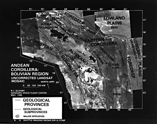
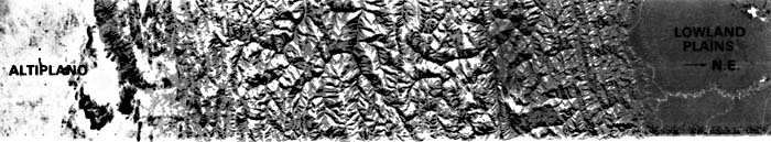
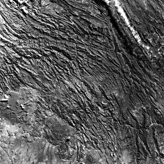
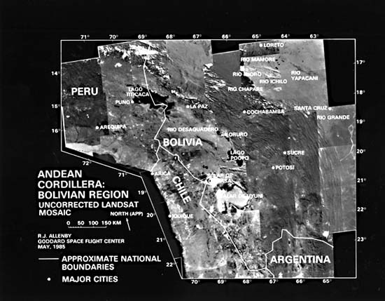
Near the border between Peru and Chile, both the coastline and interior Andean ranges change from an approximately northsouth trend in Chile to a northwest-southeast trend in Peru, a change of over 45°. This bend has been called the Arica Elbow and appears to be a major deflection zone running inland from the Chilean coastal town of Arica. The Plate is a Landsat Mosaic (28 frames) that encompasses the Andean Cordillera around this great bend. The overlap shows parts of four South American countries lying within the scene. The major geological provinces of the central Andes have been superimposed on this scene in lieu of an index map. Line A-A locates a strip of SIR-A radar imagery, placed under the mosaic, that provides more structural and topographic detail across the Eastern Cordillera. Figure T-21.1 highlights part of this elbow zone east of the Altiplano in south-central Bolivia. The northward-trending Chilean-Argentinian Andes along the left side of the image bend northwestward to form the Peruvian Andes that continue essentially in this direction to the Ecuadorian border. From southwest to northeast, the mountains are primarily composed of highly folded and faulted Ordovician, Silurian, and Devonian sedimentary rocks. The topographic grain that sweeps around this elbow in a large "S" curve is the result of differential erosion etching out many imbricate thrust faults and the tilted and folded sedimentary rocks involved in the faulting. In the southwest corner of the scene, younger volcanic and volcanoclastic rocks mask the underlying structure. Much of the younger faulting parallel with the trend of the cordillera in this section is either high-angle normal or reverse associated with uplift. Farther to the east in the Andean Foredeep area, the faulting becomes exclusively high-angle reverse. The relatively flat terrain in the bottom left quadrant consists of Tertiary volcanics on the eastern edge of the Altiplano southeast of Lago Poopo. The Bolivian city of Sucre is located in the lower left center of the image. The important mining center of Potosi appears at the bottom center edge of the image on a bulge caused by a Tertiary intrusion, which is the source of the rich mineralization.
| Figure T-21.3 |
|---|
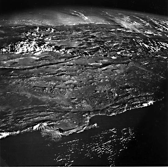 |
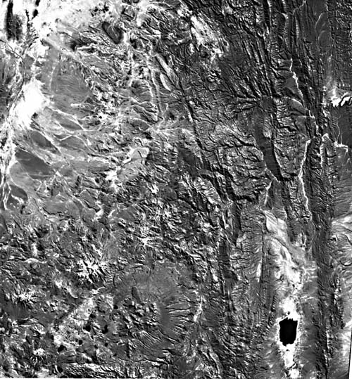
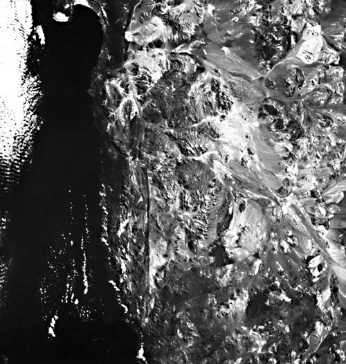
Figure T-21.2, another Landsat view of the Bolivian Andes lying south of the Figure T-21.1 scene, shows an area where the cordillera starts to swing uniformly northwest. Two large faulted basins are evident, with interior drainage and large alluvial fans. The lake (lower right) just inside Argentina lies on the Altiplano (Puna) in one of the faulted basins between ridges of folded and thrust-faulted sedimentary rocks. West of the deformed sedimentary rocks are several large volcanic edifices (one of which shows excellent radial drainage), numerous small craters, and wide areas of smooth topography that include large alluvial fans and pediments, tuff sheets, and basin fill.
| Plate T-21.3 | Figure T-21.4 |
|---|---|
 |
 |
An oblique photograph (Figure T-21.3), taken during the Apollo 7 mission, looks east over Chile toward Argentina at the region just south of the mosaic. Lying on the South American plate adjacent to the Antarctic plates, this area also exhibits tectonically controlled geomorphology. This photograph shows a strong topographic zonation due to successive deformational events affecting the rocks of the plate margin. The band of topography behind (east of) the Salar de Atacama (center left margin) is a result of differential erosion of basic volcanic rocks topped by numerous recent volcanoes. These volcanoes and the associated effusive rocks are Pliocene to Quaternary in age. Both west and east of this band are belts of rocks deformed at the plate margin. Perhaps the most notable morphologic feature in the photograph is the right-lateral Atacama fault (near the coast), which forms a sharp topographic low along its length. The fault, as it cuts along the peninsula, is delineated by a linear ridge. Figure T-21.4 shows the same peninsula, fault, and inland Desierto de Atacama from the vertical perspective of Landsat. (GCW: R. Allenby) References: Cobbing and Pitcher (1972), Lohmann (1970), Kulm et al. (1981), Zeil (1979). Landsat Mosaic.
Continue to Plate T-22| Chapter 2 Table of Contents| Return to Home Page| Complete Table of Contents