 |
 |
|---|---|
| Plate T-25 | Map |
|
|
|---|---|
| Plate T-25 | Map |
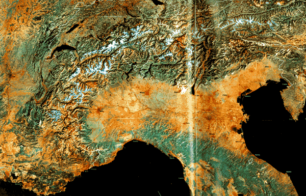
This splendid mosaic in quasi-natural color gives a synoptic view of the European Alps and related chains of mountains (see the mosaic of the western United States in Plate T-1). This mosaic provides a context for the more detailed discussions of the tectonics of the Alps and their geomorphic development in Plates T-25 and T-26.
The Alps are part of the belt of deformed rocks that extends across southern Europe into Asia Minor, thence into northern India, Russia, and China. Offshoots from the main alpine trend in Europe include the Apennines, the Dinaride/Pindar belt, and the Carpathians. A series of orogenic events beginning in the Mesozoic and culminating in the Cenozoic deformed sediments accumulated in the Tethys Sea and associated depocenters to generate the Alpine/Himalayan System (Brinkman, 1969). Most of the deformation is related to convergent margin collisions of the continent/continent type. For the Alps, this collision involved northward movement of the African plate against the Eurasian plate, partially closing the Tethys Sea, leaving behind the present Mediterranean Sea. Structurally, much of the Alps now consists of piles of allochthonous thrust sheets or nappes that were carried onto or against older landmasses. Actual tectonic transport involved compression and gravity gliding off the raised tectonic welt. Some of this gliding was submarine. The nappes and décollement folds imply a substantial amount of crustal shortening by subduction.
Folding styles range from open Jura-type décollement folds to complexly deformed recumbent folds. Orogeny began in the Late Mesozoic and culminated in the Miocene. The present rugged character of the High Alps is the result of uplift that continues today and erosion by Pleistocene glaciers.
| Figure T-25.1 | Figure T-25.2 |
|---|---|
 |
 |
A synopsis of tectonic events that contributed to formation of the Alps is as follows (Condie, 1982; Dewey et al., 1973; Windley, 1984):
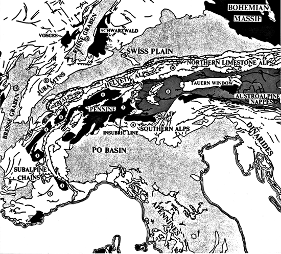
An inset map on the Plate mosaic (from Spencer, 1977) shows the structural divisions of the European Alps that are visible on the mosaic:
| Figure T-25.3 | Figure T-25.4 |
|---|---|
 |
 |
In general, there is a close correspondence between structural divisions and geomorphological or physical divisions (Embleton, 1984, Ch. 10). Four composite geomorphic zones have been recognized: (1) Pre-Alps (including Jura Mountains and Po Basin), (2) Calcareous Alps, (3) Schist Alps, and (4) High Alps. These form the broad arc that makes up the Alps proper.
The present geomorphology of the Alps is the consequence of interplay among structures established in the Tertiary, active neotectonics including vertical uplift, the continuing action of streams (many structurally controlled before the Pleistocene), and, above all, intense erosion by mountain glaciers, particularly during the Riss and Würm glacial episodes (Watts, 1971).
Structures strongly control the alignment of the main valleys. For example, longitudinal valleys are located along the strike of weaker rocks, along nappe boundaries, in tectonic grabens, or along the axes of breached anticlines. Transverse valleys, which cut across gross structures and rock types, are influenced by faults, old flextures, and axial depressions. These valleys have been widened and deepened by glacial erosion.
| Figure T-25.5 | Figure T-25.6 |
|---|---|
 |
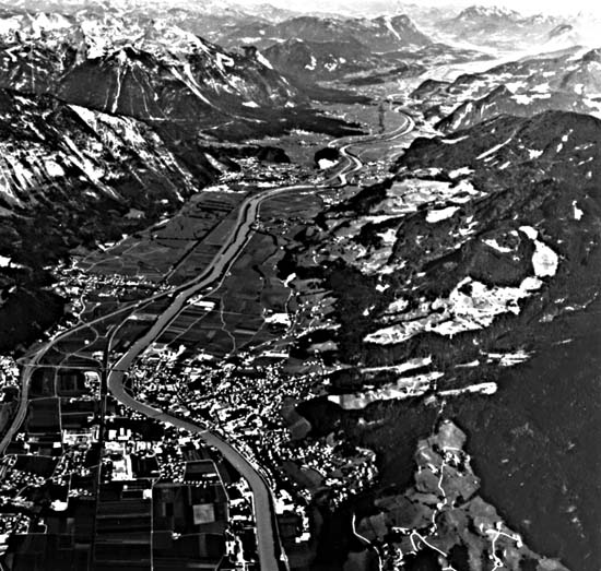 |
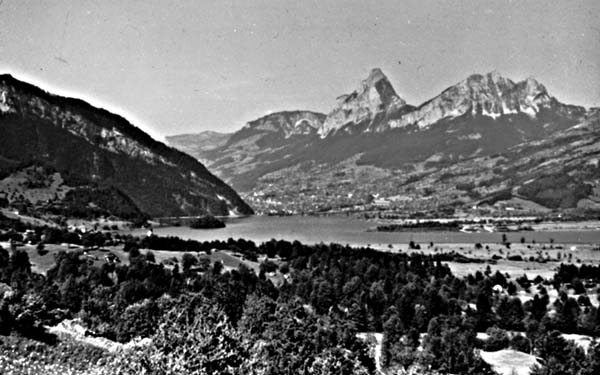
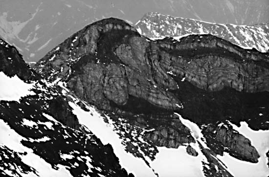
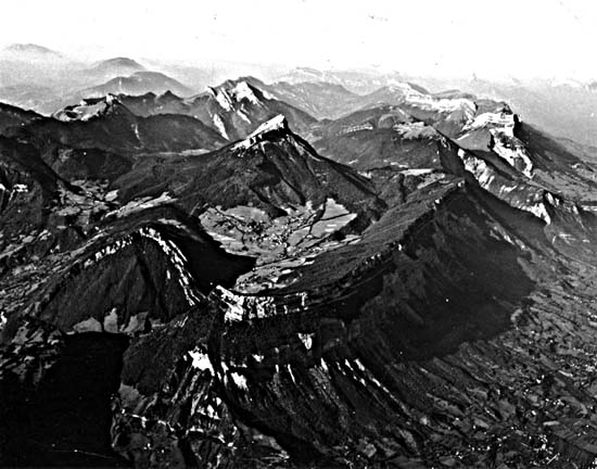
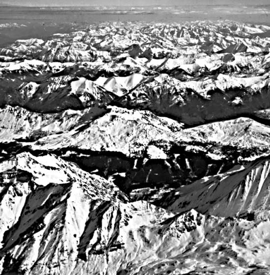
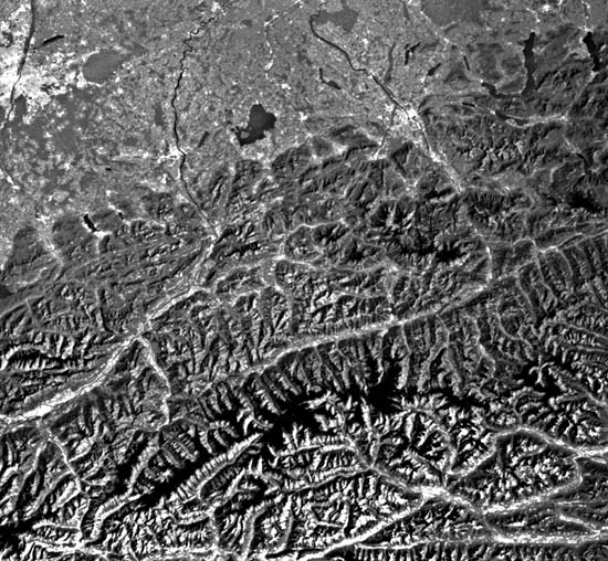
The ground and aerial photographs and space image below provide a broader perspective on the structural and physiographic character of the Alps. Figure T-25.1 depicts a horn and other terrain in the Helvetic Alps at the east end of Lac Léman (Lake Geneva). A typical flowage fold within the Pleising nappe in Austria appears in Figure T-25.2. Mountains capped by folds of massive limestone present distinct landforms in the French Alps north of Grenoble (Figure T-25.3). Figure T-25.4 shows a series of parallel ridges separated by deep subsequent stream valleys enlarged by glaciation acting on one of the mountain chains in the Niedere Tauern of Austria, seen in the next figure. Figure T-25.5 is a Landsat-5 TM thermal image centered on western Austria that illustrates the effects of warmer Sun-facing and cooler shadowed slopes (black tones = snow) in producing a sense of rugged high-relief terrain. Long glacially enlarged valleys cutting through the mountains include those occupied by the Inn, Salzach, Enns, Isel, and Drava Rivers. Figure T-25.6 is an aerial view down the valley of the Inn River east of Innsbruck. (NMS) Landsat Mosaic.
Continue to Plate T-26| |Chapter 2 Table of Contents| Return to Home Page| Complete Table of Contents