 |
|---|
| Plate T-31 |
|
|---|
| Plate T-31 |
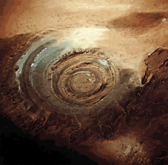
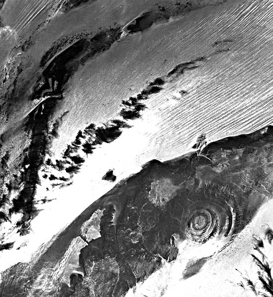
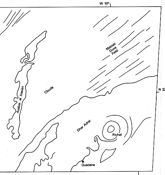
The bull's-eye target pattern of the Richât structure on the barren Gres de Chinguetti Plateau in the Adrar region of central Mauritania is an eye-catching feature when seen from space, as is evident in the color Plate photograph taken looking south from the 17th Shuttle mission. Sand has drifted northward and encroaches on part of the southern half of the 38-km wide structure. The Makteir desert abuts the plateau to the north (Figure T-31.1). Although reminiscent of multiringed impact structures on the Moon, Mercury, and Mars, field and laboratory evidence suggests that the Richât structure is a dome of endogenic origin.
| Figure T-31.1 | Map |
|---|---|
 |
 |
Richât, slightly elliptical and with its long axis oriented northeast (upper right corner in Figure T-31.2, a vertical air photograph), lies in a depression in which drainage is annular and radial and topographic relief is about 100 m. The strata dip outward, so that weathering and erosion of the alternating resistant and nonresistant Late Precambrian and Early Paleozoic rocks have produced a series of inward-facing cuestas (Figure T-31.3). Quartzite forms the resistant circular ridges, and less resistant rocks underlie the intervening annular depressions, some of which contain seasonal lakes. The center of the structure, the Guelb er Richât (Figure T-31.3), exposes flat-lying limestone and some meta-arkose surrounded by a massive ridge of chert and chert breccia. The overlying part of the stratigraphic section, well exposed outward in the dome, consists of Upper Precambrian/Lower Paleozoic shelf facies rocks.
The quaquaversal dip of the beds increases inward 20 to 25°; locally, dips are as great as 35°. Some minor radial and tangential faults occur in the outer parts of the structure. The north part of the structure is cut by a fault system oriented N30°E that appears to be unrelated to the formation of the dome. Reconstruction of the eroded beds of the structure suggests that they were uplifted 3 to 4 km to form the dome.
Reconnaissance gravity data do not support the presence at a reasonable depth of an igneous or diapiric intrusive mass nor do they suggest the presence of low-density breccia layers characteristic of impact structures. However, deep erosion could have removed the brecciated lens. Thus, the gravity data neither confirm nor preclude an impact origin for the structure.
| Figure T-31.2 | Figure T-31.3 |
|---|---|
 |
 |
Dolerite sills and dikes crop out at several localities within the structure. Associated analcime-rich rock has been interpreted by some to be the result of hydrothermal alteration of rhyolite sills and dikes. No evidence of volcanic activity exists at Richât.
Some geomorphologists have interpreted Richât as an impact structure because of the nearly circular "bulls-eye" pattern, the reported presence of coesite, the uniqueness of the structure in the region, its interior drainage, and the presence of nearby impact structures-Aouelloul, some 150 km to the southeast, and Tenoumer to the north (Plate T-61). Most geomorphologists now consider Richât to be an endogenic structural dome of purely terrestrial origin. An impact origin is discounted by Monod and Pomerol (1973) for these reasons:
Semsiyat dome, 50 km west-southwest of Richât and centered at latitude 210°'N and longitude 1105°'W, has a diameter of 5 km. Although the style of deformation is similar to that of Richât, Semsiyat is barely detectable on the ground. The structure lies on the Chinguetti Plateau and has only a few meters of topographic relief. Strata dip so slightly that field measurement is difficult. Exposures are poor, and the rocks are extremely weathered. No evidence of shock metamorphism has been discovered at Semsiyat; like Richât, it is believed to be a dome of endogenic origin (Dietz et al., 1967). (GCW: J. R. Underwood) STS-61A.
Continue to Plate T-32| Chapter 2 Table of Contents| Return to Home Page| Complete Table of Contents