 |
 |
|---|---|
| Plate T-32 | Map |
|
|
|---|---|
| Plate T-32 | Map |
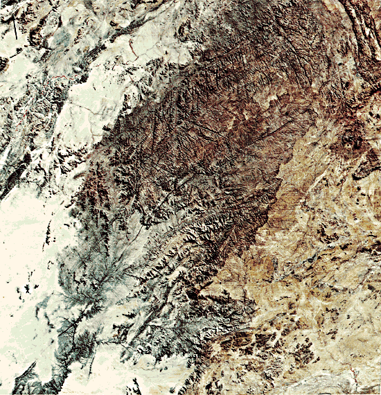
The Damara Mountain Belt is an outstanding example of a Late Precambrian/Early Paleozoic ocean basin whose shelf or trailing edge and deep-water or trench deposits remain well preserved. The belt occupies an extensive outcrop area in central and northern Namibia (South-West Africa) trending northeastward from the coastline inland some 400 km. It may continue beneath the Cretaceous-Tertiary Kalahari sedimentary rocks in Botswana and the Pan-African suture zone of the Zambesi Valley. This belt of ancient sedimentary rocks, now regionally metamorphosed, accumulated between two continents, the Congo on the north and the Kalahari on the south.
Deposition in the Damara basin began perhaps as early as 700 Ma ago. The shelf rocks lie in Angola to the north of this scene. Most of the Damara consists of the Swakop facies, mainly graywackes and shales more than 10000 m thick that are metamorphosed to schists and gneisses. Some deformation is as old as 680 to 580 Ma, but the major collisional activity took place during the Pan-African Tectonic Episode from 450 to 550 Ma ago. This Damaran orogeny imposed a strong northeast structural fabric on the region, with folds locally overturned, intrusions commonplace, and extensive faulting in places.
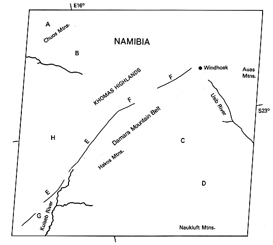
Deformation and metamorphism show maximum intensity in the areas around A, B, and C on the index map. High-grade metamorphosed rocks associated with abundant intrusions of anatectic granites and pegmatites characterize these crystalline terranes. The folding is expressed by the resistant ridges and eroded valleys. In the southern zone around the Eiseb River and the Naukluft Mountains (highest point 2245 m), complex folds, nappes, and thrust faults with reactivated granitic cores and other basement plutons are typical (D). The Auas Mountains (maximum elevation 2465 m), a transverse range held up by the Quartzite Series, are now eroded into a dissected plateau.
| Figure T-32.1 | Figure T-32.2 |
|---|---|
 |
 |
The conspicuous Khomas Highlands plateau (average elevation of 2100 m), is an older erosion surface cut on the same Damaran rocks as the more dissected area to the east. The structural trends visible in the plateau in the area to the west are more subdued. Because of a great degree of planation and weathering, it is easier, in many locations, to trace the stratigraphy from the space imagery than on the ground. On the surface, graphitic schists serve as marker horizons. A well-defined narrow black line (E and F) is actually a serpentinite that marks the suture zone. It is known in the region as the Matchless Belt, within and around which are a number of base metal mines. The Khomas Highlands are also distinguished by prominent lineaments in two dominant sets, north-south and northwest. Most of these are joints, but a few are traces of faults that offset marker units. The Hakos Mountains, a large northeast-plunging anticline made up of crystalline Swakop facies, lie south of the highlands.
Both these mountains and the Highlands are bounded on the west by the Great Escarpment (G and H) of southern Africa, a post-Eocene erosion feature not as well developed here as in the Cape Province of South Africa (see Figure 1-7). The scarp is the result of the current cycle of erosion cutting headward into an older erosion surface. In fact, four of L. C. King's (1967) lateral erosion surfaces, each interrupted by a regional uplift event (cymatogeny), are found over the scene; the Jurassic Gondwana surface cuts across much of the Khomas Highlands; the African surface occupies most of the lower right part of the image; the younger post-African surface extends along the lower left of the image; and the youngest Congo surface lies along the Kuiseb River valley. Tertiary to Recent alluvium and sands extend to the west. In the lower right corner of the scene are sedimentary beds of the Nama System, which were broadly folded during the late phase of the Damara collision.
| Figure T-32.3 | Figure T-32.4 |
|---|---|
 |
 |
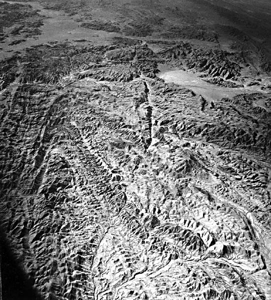
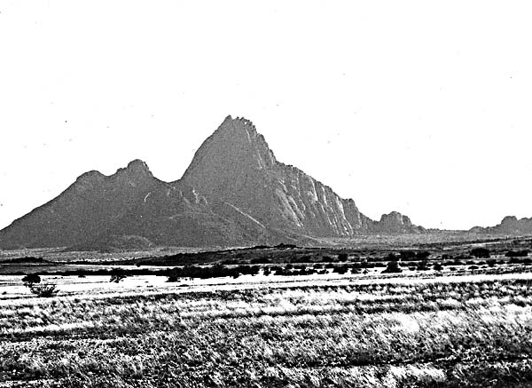
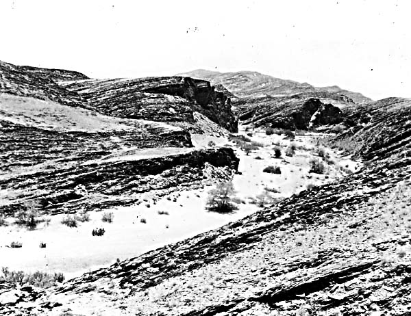
In Figure T-32.1, the outcrops of Damara facies rocks define an asymmetrical plunging syncline with a characteristic sharp short nose. Figure T-32.2 is a fine example of a bornhardt (der grosse Spitzkopf) or erosion remnant standing on a pediplain. Figure T-32.3 shows how erosion is guided by foliation in metamorphic rocks (relict bedding?) along the Kuiseb River.
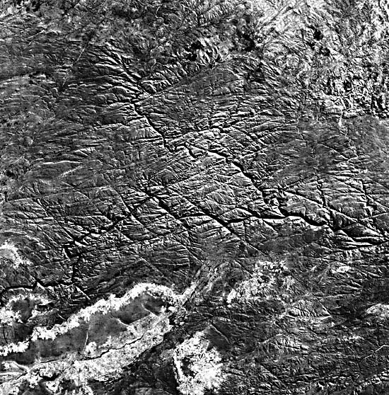
The conspicuous large joints and faults cutting across the Khomas Highlands form weaker areas where erosion is concentrated and which guide the paths of rivers. This same control is beautifully displayed in Figure T-32.4, a Landsat-4 TM subscene (enlargement) of a plateau traversed by the Zambesi River near Victoria Falls, some 1500 km northeast of Windhoek. This river and its tributaries have sharp angular bends where their downcutting has carved canyons along the intersecting joints that crisscross the karroo basaltic units capping the plateau. (NMS) Additional References: Burke and Dewey (1970), de Villiers and Simpson (1974), Furon (1963), Truswell (1970), Viljoen and Viljoen (1975). Landsat 1382-08205-7, August 9, 1973.
Continue to Plate T-33| Chapter 2 table of Contents| Return to Home Page| Complete Table to Contents