 |
 |
|---|---|
| Plate T-33 | Map |
|
|
|---|---|
| Plate T-33 | Map |
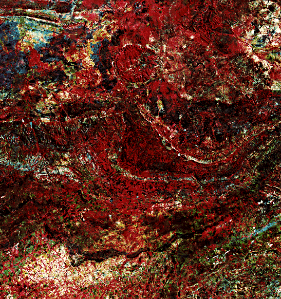
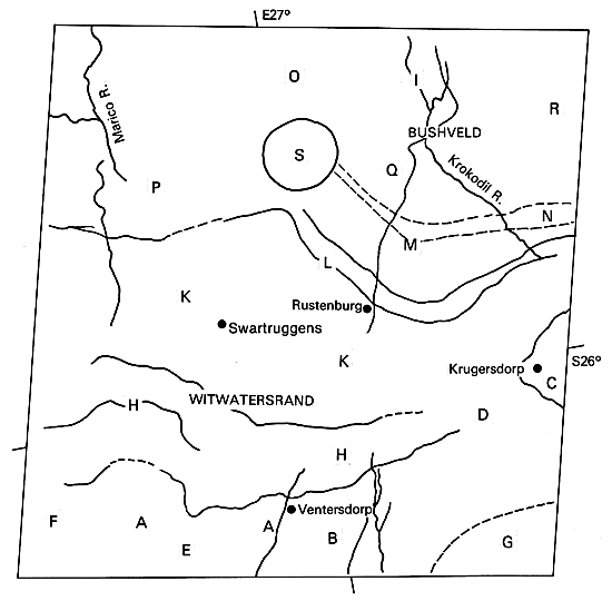
The largest of the ancient shield nuclei in the African continent is located in eastern South Africa. Known as the Transvaal or Kaapvaal Craton, this shield contains plutonic, metamorphic, and metasedimentary rocks older than 2.5 Ga. Although younger Precambrian units cover much of the southern and western parts of the craton, the old basement complex, including Archean granite/greenstone belts, crops out along the eastern and much of the northern parts of the craton.
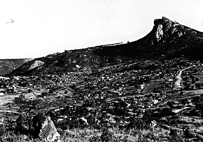
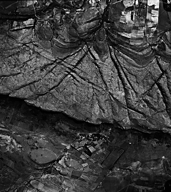
The Plate covers the part of the craton lying slightly west of Johannesburg and Pretoria (just off the right-central margin) and just north of the Vaal River. Two physiographic regions, the South Africa High Veld (lower part of the image) and the Transvaal Plateau Basin (upper) appear in the scene, which itself extends across sections of the Witwatersrand and Bushveld geologic provinces. Elevations in these regions are between 1500 and 1600 m. The High Veld is mainly undulating grass country; the Transvaal Plateau contains eroded plains (Figure T-33.1, an aerial photograph) and ridges (Figure T-33.2) of resistant quartzite whose distribution is controlled by the Bushveld structure. Most of the terrain is a pediplain within the Late Cenozoic/post-African denudation surface, but a remnant of the Early African surface cuts across the lower half of the image.
| Figure T-33.1 | Figure T-33.2 |
|---|---|
 |
 |
Outcrops of the Basement (or "Old") Granite in the Swazi Erathem System are limited to the areas around A on the index map, but land-use patterns obscure their expression in the image. The next younger group of rocks comprise the Early Proterozoic Witwatersrand Supergroup. This triad includes the Dominion Reef Group, the overlying Witwatersrand Group (exposed at B, C, and D), and the Ventersdorp Group (exposed at E, F, and G). Within the Witwatersrand are the "reef" units, layers of quartzose conglomerates that carry both disseminated and nugget gold, which makes this region the greatest world supplier.
In this scene, a quadrant of the near-circular Vredefort Dome (G) contains Ventersdorp units along with inner Witwatersrand beds surrounding the Old Granite in its core (off the lower right corner). This structure, with its overturned rimming strata, has been explained as a diapiric intrusive plug, but the discovery of shatter cones and other shock-induced metamorphic features in its central granite suggests that it possibly originated as an ancient impact crater now eroded to an astrobleme.
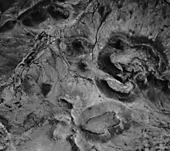
Strongly folded Proterozoic Transvaal Supergroup rocks appear in the central part of the image, where they dip northward toward the Transvaal basin, and at an inlier around J. The Dolomite Series (at H and I), 1000 to 2000 m thick, includes darker chert-poor and lighter chert-rich stratigraphic zones. Overlying it is the Pretoria Formation, up to 8000 m of shales and quartzites, some of the latter holding up ridges and escarpments as at K and L. Numerous regional fractures, some of which truncate or offset the units, cut both series (Figure T-33.3). These faults and joints also localize water, as is evident during the rainy season when linear vegetation marks them (see Short et al., 1976, Plates 353 and 354).
| Figure T-33.3 | Figure T-33.4 |
|---|---|
 |
 |
Transvaal deposition ended with emplacement of the Bushveld Complex about 1950 to 2000 Ma ago. This huge igneous terrain (66000 km2), once supposed to be a great lopolith, covers the upper third of the image, but extends over an even larger area to the northeast. The Bushveld event began with extrusion (east of scene) of felsites and granophyres, with concomitant subsidence of Transvaal units as magma withdrawal weakened support. The Main Plutonic phase involved emplacements of several funnel-shaped intrusions into both the felsites and Transvaal (Pretoria) units from at least five centers. This first produced gabbros, then pyroxenites and norites, that attain thicknesses in excess of 9000 m. Basic intrusions occupy areas around M, N, O, and P. Within these are differentiated cumulate layers of magnetite and chromite. Later granite rocks of the Acid Intrusive Phase intruded between the ultrabasics and felsites; these form a plains around Q and R. About 1.4 Ga ago, several alkaline intrusions penetrated the Transvaal craton. The largest, the Pilanesberg (S), consists of syenite and foyaite that form concentric hills.
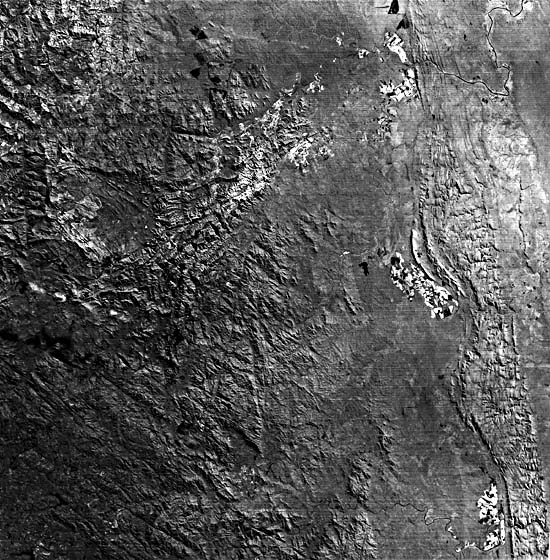
Figure T-33.4, a Landsat image, depicts the ancient terrane (older than 3.0 Ga) carved from the Barberton Mountain Land greenstone and other units exposed on the east edge of the Transvaal Craton. The infolded greenstones were derived from volcanic rocks and chert-rich sediments (Onverswacht Series, which contains spheroidal and filamentous micro-organisms), graywackes and shales (the Fig Tree Series, which contains primitive algae and other life-forms), and feldspathic sandstones and shales of the Moodies Series. Erosion has accentuated the folds, faults, and fractures in this terrane. Compare this greenstone/pluton belt with the Archean terranes of Western Australia (Plate T-55). (NMS) Additional References: Anhauesser and Robb (1980), Fripp et al. (1978), Simpson (1978), Windley (1984), Furon (1963), Hamilton and Cooke (1959). Landsat 10230-07370-7, March 10, 1973.
Continue to Plate T-34| Chapter 2 table of Contents| Return to Home Page| Complete Table of Contents