 |
 |
|---|---|
| Plate T-34 | Map |
|
|
|---|---|
| Plate T-34 | Map |
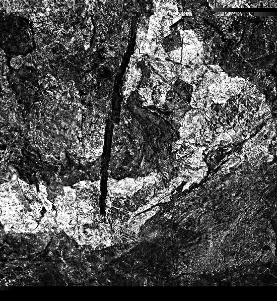
Southern Africa contains extensive exposures of the African Shield, a cratonic complex consisting of accreted arcs and microplates that have built up from collisional terranes. These terranes are replete with sutures, infolded sedimentary rocks, and intrusions of granitic rock. Isotopic ages range from 3800 to 500 Ma. The Plate scene shows the southern Zimbabwe (Rhodesian) Craton and one of the most remarkable intrusive bodies in the world, the Great Dike of Zimbabwe (also referred to in older reports as the Great Dyke of Rhodesia).
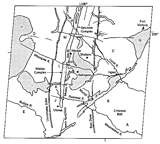
On the south, the Limpopo Mobile Belt, a 900-km long, 200-km wide ancient mountain belt (including metasediments as old as 3.8 Ga and clastic sediments as young as 2.5 Ga), separates the Zimbabwe Craton from the Kaapvaal Craton in the Transvaal of South Africa (plate T-33). Highly deformed greenschists, anorthosites, and gneisses (seen on the index map at A and B) were thrust from the south against the Zimbabwe Craton about 2700 Ma ago.
The Zimbabwe cratonic terrane is an excellent example of an Archean greenstone/granodioritic complex (MacGregor, 1951). Volcanic rocks, graywackes, cherts, banded iron formation, and other sedimentary rocks have been metamorphosed into low-grade schists and amphibolites. These comprise strongly deformed, arcuate, synformal belts enclosed within older rocks. "Gregarious batholiths" (MacGregor, 1951), diapiric granites/ tonalites, including the Chibi batholith at C and segments of the Shangani and Malopo batholiths at D and E, occupy large parts of the image.
| Figure T-34.1 | Figure T-34.2 |
|---|---|
 |
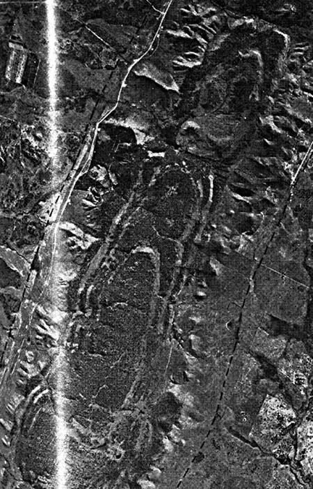 |
The Plate scene and Figure T-34.1, another Landsat frame that depicts the craton around Salisbury and to the east, illustrate the terrain typical of the region. The greenstone belts (Sebakwian Group (~3.3 Ga), Bulawayan Group (2.7 Ga); with contorted infolds at F, G, H, and I; Shamvaian Group (2.65 Ga)) are conspicuous, but the gneisses, granulates, and granites form featureless low-relief topography. The savannah veld contains obscuring patterns of land use, including large light-toned cleared areas that superficially resemble plutons. In Figure T-34.2, the northeast corner of Zimbabwe, circular clusters of castle kopjes (degenerate bornhardts) -rocky hills of resistant granite- are remnants of several plutons (e.g., Mtoko near the center). The arrangement of the kopjes suggests that weathering and erosion proceeded along fractures (joints) that enlarged over time.
| Figure T-34.3 |
|---|
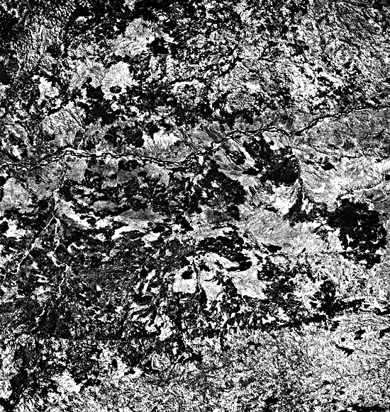 |
The Great Dike itself, conspicuous on the image and in an aerial photograph (Figure T-34.2), is a topographic ridge of low relief with linear outer ridges developed on cumulate layers that dip gently inward near the contact of the dike with the country rock. The dike (average width of 6 to 8 km) runs about N15°E for nearly 500 km across Zimbabwe. The term "dike" for this structure is somewhat misleading in a strict sense. The narrow linear dark band seen in the Plate is actually the feeder conduit for four contiguous lopoliths intruded about 2.5 Ga ago into several north-trending fractures within the craton during an extensional tectonic phase. The intrusions spread subhorizontally in one or more thick, dense units. Later faulting (normal with some strike-slips along west-northwest or east-west trends) offsets the lopoliths and their feeders, easily seen in the Plate (at J, K, L, M). Subsequent deep erosion over the last 2.5 Ga has stripped off most of the spread-out lopolithic mass, leaving only its feeder roots in the form of the largest "dike" known on Earth. Smaller subsidiary dikes, Umvimeela and East, also served as feeders.
Each of the lopoliths' feeder segments, the Wedza and Selukwe complexes in the Plate and the Hartley and Musengezi Complexes to the north, is characterized by similar distinctive petrology and internal structure. Where exposed or drilled, each of the lopoliths is layered with a gentle syncline bend perpendicular to the dike axis. The topmost unit is usually gabbroic, seen in the Landsat images as patches of lighter toned rock. Lower units consist of cyclic bands (cumulates, often many meters thick) of orthopyroxenite, picrite, harzburgite, and chromite seams. Structural relations and gravity distribution suggest that the "dike" is a permissive intrusion with vertical contacts emplaced in an extensional stress field; it seemingly is not the initial phase of continental rifting.
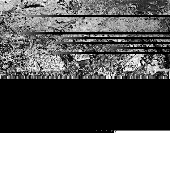
The Zimbabwe shield ends abruptly along a suture line against the Zambesi belt to the north. This is strikingly evident in a Landsat image (Figure T-34.3) that shows darker tones where the Zambesi belt meets the shield. An escarpment marks the contact, and both topography and structural grain are somewhat different in this northern terrane. (The irregular light-toned patches result from land cultivation practices.) The Zambezi River here flows eastward from Zambia to Mozambique. (NMS) Additional References: Bichan (1970), Furon (1963), MacGregor (1951), Pritchard (1979), Stagman (1978), Worst (1960). Landsat 10103-07291-7, November 5, 1972.
Continue to Plate T-35| Chapter 2 table of Contents| Return to Home Page| Complete Table of Contents