 |
 |
|---|---|
| Plate T-38 | Map |
|
|
|---|---|
| Plate T-38 | Map |
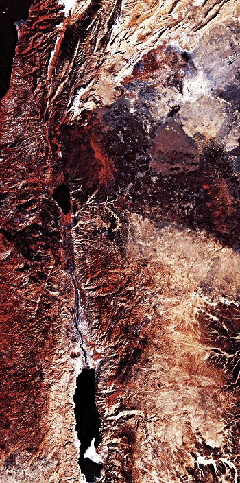
Along the eastern margin of the Mediterranean Sea, a major left-lateral transform fault extends from a spreading center at the northern end of the Red Sea through the Gulf of Aqaba, the Dead Sea, and the Sea of Galilee to a zone of continent/continent collision in the Taurus/Zagros Mountains in southern Turkey (Plate T-39). This fault is known by different names along its extent, but should probably be called the Levant fault zone. It is approximately 1000 km long and bounds the western edge of the Arabian plate. As can be readily seen on the Landsat mosaic and Figure T-38.1, an Apollo-Soyuz photograph, the fault is not straight, but exhibits angular bends that have produced zones of pull-apart grabens (Gulf of Aqaba, Dead Sea, and Sea of Galilee) and compressive bulges (Lebanon, Anti-Lebanon, and Palmyra Mountains). This has resulted in impressive differences of topography. The Jordan River Valley and the Sea of Galilee (G) lie 200 m below sea level in a pull-apart basin. In contrast, the elevation of the Lebanon Mountains, the focal point of compression at a bend, exceeds 3000 m above sea level. These mountains receive the largest quantities of snow and rainfall in the Levant area, and the runoff to the sea only 30 km away has carved several deeply incised channels and gorges on the western slopes of the mountains.
The part of the Levant fault portrayed in the mosaic has been subjected to intermittent volcanism since Mesozoic time, and flows of various ages ranging from Pliocene to Recent (particularly Pleistocene) are extensive (Garfunkel et al., 1981). Much of the area east of the Jordan Valley and south of Damascus is covered by basaltic lavas. Several cinder cones of Recent age can be seen on the Golan Heights, a plateau, and on Gebel ad Drouz. East of Damascus is an extensive field of cinder cones. Many of these cinder cones have formed along fissures up to 15 km in length.
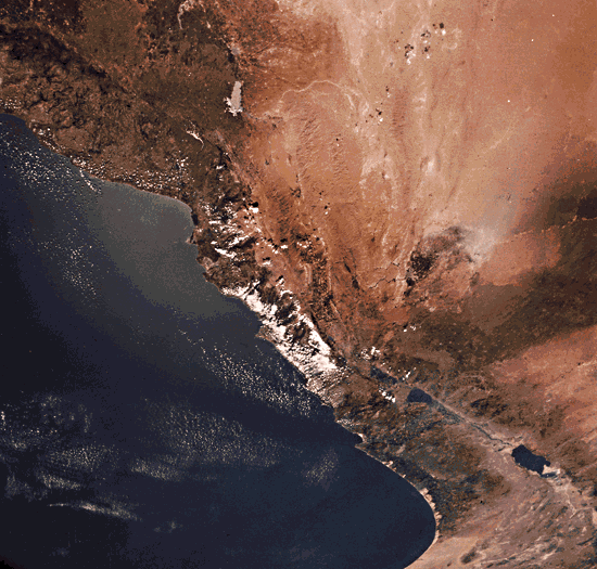
Another basaltic flow west of Homs, Syria, forms the Shin Plateau. This flow extends across the Levant fault zone nearly to the Mediterranean Sea (Ponikarov, 1967). Southwest of the Sea of Galilee, a basaltic flow forms the resistant plateau that accentuates the differences in relief of greater than 500 m to the valley floor of the Jordan River.
| Figure T-38.1 |
|---|
 |
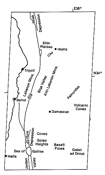
Near the Lebanon/Israeli border, the Levant transform fault deviates from the Jordan Valley trend by about 25° to the east. This change in trend marks the transition along the fault from a transtensional to a transpressional regime. This zone of compression coincides with the development on the east side of the fault of a series of subparallel faulted anticlines and synclines known as the Anti-Lebanon, and farther east, the Palmyra Mountains. The first major structure east of the fault is the Biqa Valley, a broad synclinal structure. This valley is flanked by a large faulted anticlinal fold more than 20 km wide, with elevations exceeding 2600 m, that is part of the Anti-Lebanon Mountains (Dubertret, 1955).
In the Palmyrides, both the widths and heights of the structures are less imposing. The anticlinal folds are tighter, and many of the crests appear to be longitudinally faulted.
At the northern end of the Lebanon Mountains, the trend of the Levant transform fault nearly parallels the Jordan Valley segment. The compressive bulge along the fault abruptly diminishes at this point. Evidence of tension is suggested by the presence of a probable rhomb graben at the west side of the Shin Plateau. Evidence for the graben is confused by a large elongate volcanic ridge that was apparently the source for the extensive basaltic cover that formed the Shin Plateau. Farther north along the fault, the Rhab depression is definitely a graben structure with a width exceeding that of the Jordan Valley. The Apollo- Soyuz photograph (Figure T-38.1) shows the extension and change of direction of the lineament northward and the folds on the east of the fault.
The Levant fault is an instructive example of a major left lateral strike-slip fault. Differences in the width of the Red Sea and the Gulf of Suez and the orientation of the folds in the Anti-Lebanon and Palmyra Mountains indicate the sense of movement. Transitions from zones of transtension (where the trace of the fault is locally more westerly) to zones of transpression (where the fault trends more easterly) are characteristic of many major strike-slip faults, (GCW: O. R. Russell) Landsat Mosaic.
Continue to Plate T-39| Chapter 2 table of Contents| Return to Home Page| Complete Table of Contents