 |
 |
|---|---|
| Plate T-5 | Map |
|
|
|---|---|
| Plate T-5 | Map |
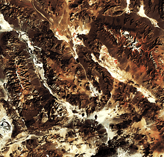
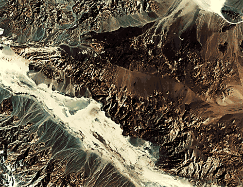
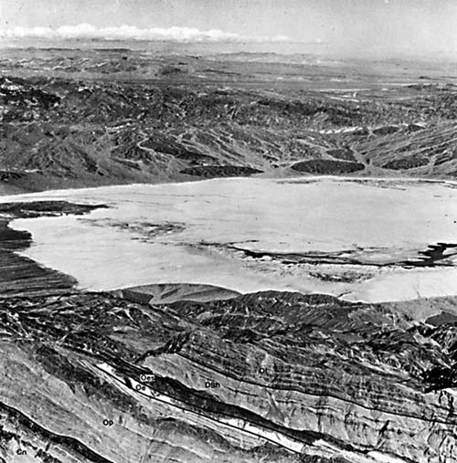
This TM scene shows the southwestern portion of the Great Basin (Basin and Range province) where it abuts the northern Mojave Desert along the Garlock fault (A on index map). The center of the scene straddles the California/Nevada border about 150 km west of Las Vegas. In the upper left part of the image lies Death Valley, within which is the lowest surface point (-86 m) in North America, the Badwater basin. Only about 120 km farther to the west across the Owens Valley, along the eastern front of the Sierra Nevada, stands Mt. Whitney (4418 m), the highest point in the conterminous United States. Compare the detail present in part of the TM scene with the equivalent area from a 1973 Skylab photograph (Figure T-5.1). It is also instructive to compare a subscene from a June 1984 TM image (Figure T-5.2) that has been enhanced to bring out details of the stratigraphic/topographic sequence in Tucki Mountain, which overexposes the saline deposits in Cottonball Basin (I), with an aerial oblique photograph of much the same area (Figure T-5.3).
| Figure T-5.1 | Figure T-5.2 |
|---|---|
 |
 |
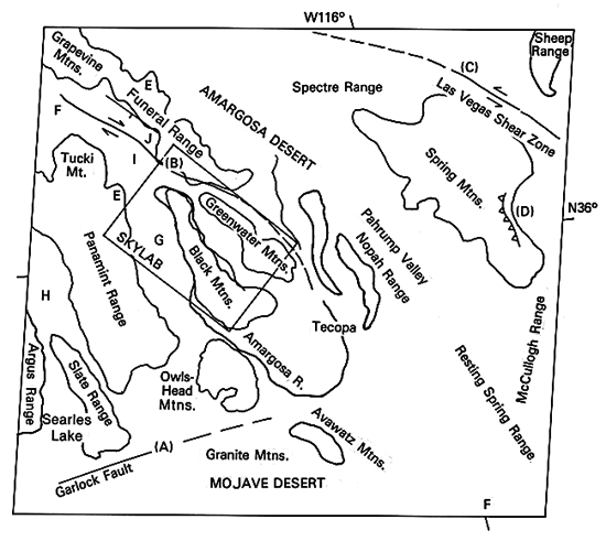
Like other ranges of the Basin and Range, normal faults are frontal to or otherwise bound the blocks (e.g., west side of the Funeral Range and the Black Mountains) that comprise the mountain ranges in this area, as demonstrated by the linearity of the mountain base. Because divides here trend northwest to north-northwest, they differ from most similar ranges in Nevada, which have north to north-northeast trends (Plate T-4). Many ranges in another structural unit, the Mojave Desert, are oriented east-west. Here, the northwest alignment is controlled in part by the orientation of several major strike-slip fault zones such as the Furnace Creek Zone (B) and the Las Vegas Shear Zone (C), all of which are right-lateral faults. The Las Vegas Shear Zone is an eastern branch of the Walker Lane wrench zone that continues to the northwest for some 200 km; the faults along the Grapevine and Funeral Range join the same zone.
Most of the ranges consist of Paleozoic miogeoclinal sedimentary units and some Mesozoic sedimentary rocks. Folding and strong eastward thrusting affected these rocks during the Antlerian (Mid-Paleozoic) and Sonoran (Mid-Mesozoic) orogenies. Numerous imbricated thrust sheets make up much of the eastern Panamint Range. Tertiary volcanic rocks occur in the Owlshead Range, around the Granite Mountains and the Greenwater Ranges, and in the Spectre Range and Black Mountains. Silicic volcanic rocks remain along the eastern side of the Grapevine Mountains and along eastern Tucki Mountain. Rhyolites and basalts have been emplaced during the last 10 Ma in the valley and elsewhere (F, Devils Playground).
The present structure and its topographic expression in this part of the Great Basin began to develop about 10 Ma ago with initiation of movement on the Furnace Creek fault system. Miocene/Pliocene lacustrine beds indicate that, as movement occurred, lakes formed along the downfaulted zone. During that time, uplift, faulting, and erosion, accompanied by volcanism, produced thick sediment accumulation (gravels and muds) in the incipient basin depression. In Late Pliocene (5 to 3 Ma ago), the region became transtensional, allowing rocks to adjust differentially along high-angle faults, some of which previously showed right-lateral movement. Movement continued on several of the right-lateral faults and accelerated on the left-lateral Garlock fault to the south. The strong vertical movement and subsequent erosion produced the present topography.
The linearity of the mountain base in the Panamint and Funeral Ranges indicates faulting. The Slate Range is separated from the Panamint Range by a fault valley. The Furnace Creek fault zone is marked by the depression occupied by Death Valley. "Wineglass" valleys, with the flaring basins and fans joined by the "stem" where the stream debouches the mountains through a narrow gorge, are common and provide evidence of faulting. Alluvial fans themselves are a result of watershed erosion along a steep scarp face produced by faulting. Triangular facets (spurs), although eroded, can be identified, again indicating faulting. Several "turtlebacks," smooth curved surfaces, can be seen along the Black Mountains front. These were formed by fault movement. Arcuate ridge forms in the central Black Mountains are controlled by faulting. Some valleys are offset and shuttered.
| Figure T-5.3 | Figure T-5.4 |
|---|---|
 |
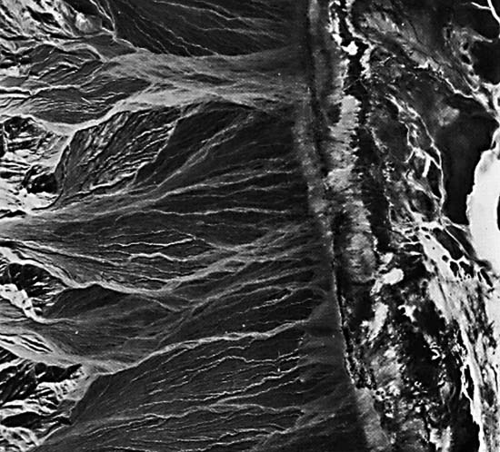 |
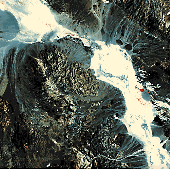
Death Valley, Panamint Valley (H), and other low areas include outstanding examples of arid landforms. Most conspicuous are the playas and salt pans. Cottonball Basin (I) is a remarkable example of saline deposition that includes sodium borates and sulphates, gypsum, encrustations of rock salt, salt-cemented mudstones, carbonates, and lake and floodplain sediments. The valleys also contain excellent examples of pediments, alluvial fans, and bajadas. Many fans have distributaries that are emphasized in the imagery by darker material spread over lighter and older materials. Both color and amount of dissection appear to differentiate fans of different ages.
Several generations of fans are evident in Figure T-5.4. The higher trenched dissected surfaces are older, then an intermediate fan, and finally, the fan presently in process of construction. This series of coalescing fans is called a bajada (bahada). Conspicuous triangular facets lie at the interplains between fans. (NMS) References: Hildreth (1976), Hunt and Mabey (1966), Streitz and Stinson (1977), Thornbury (1965). Landsat TM 40124-17495, November 19, 1982.
Continue to Plate T-6| Chapter 2 Table of Contents| Return to Home Page| Complete Table of Contents