 |
 |
|---|---|
| Plate T-52 | Map |
|
|
|---|---|
| Plate T-52 | Map |
Among its many geologic wonders, China contains some of the most spectacularly exposed and expressed examples of décollement (detachment folds) in the world. The Sichuan basin of central China includes some of the best samples of this style of deformation. Away from the margins of the basins, the folds are relatively simple. Several of the anticlines are more than 200 km long, with widths of less than 10 km. The anticlines are breached, with long gentle plunging noses and flatirons along the outside of the fold. Broad open synclines more than 20 km wide lie between the narrow anticlines. As one approaches the margins of the basin, the structures become tighter and more complex, synclines narrow, anticlines lie upon anticlines, thrust faults replace synclines and even take the place of anticlinal axes so that one is confronted with a series of imbricate thrusts sheets. Differential erosion of the Jurassic through Cretaceous rocks that comprise the folds allows one to trace particular lithologic units the entire length of some folds. The presence of a well-developed karst topography on the carbonate sequence provides an excellent regional stratigraphic marker that is easily spotted from space.
Décollement folds are similar to the wrinkles produced in a rug sliding on a smooth floor. All that is required is separation of a (more competent) layer from an underlying (less competent) layer as deformation proceeds. A homogeneous layer of essentially uniform thickness overlying a less viscous layer produces the most spectacular folds. The incompetent layer can be evaporates, shales, or even heated lower crust (i.e., any situation that will provide a viscosity inversion with depth).
Décollement folds also imply a mismatch in the horizontal dimensions of the layer above the detachment zone and the layer below the zone. The upper layer is larger in at least one dimension. Several sets of circumstances can produce this mismatch: the upper layer can be stretched as in diapiric folds, the upper layer can break away and slide off an uplift, or the lower layer can be shortened by thrusting or subduction. In the Appalachians and the Anti Atlas (Plates T-11 and T-30), subduction attendant to continental collision shortened the lower layer (lower continental crust). In the Western Overthrust Belt of the central Rocky Mountains (Figure T-6.1), continental telescoping and thickening shortened the lower layer. In many basins, shortening is accomplished by thrusting at the margins; this is true on the west side of the Sichuan basin and is probably true on the east side as well, accounting for the increased complexity of structure near the eastern margin of the basin.
| Figure T-52.1 | Figure T-52.2 |
|---|---|
 |
 |
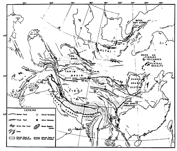
The Sichuan basin has acted as a stable block, with relatively little internal deformation, lying between two large left-lateral faults; the Kansu to the north and the Kang Ting on the southwest (Figure 2-2). The collision of India and Eurasia, beginning in the Late Eocene, reactivated the Lung Men Shan thrusts on the west side of the basin, and the tight folds and thrusts on the east are all structures that were formed in the Mid-Mesozoic. This two-phase deformation history accounts for the apparent anomalies in the strain field (Molnar and Tapponnier, 1975; Tapponnier and Molnar, 1977; Zhang and Liou, 1984).
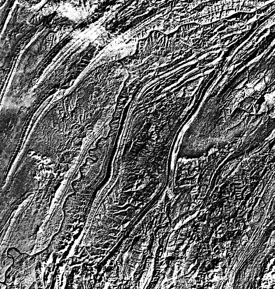
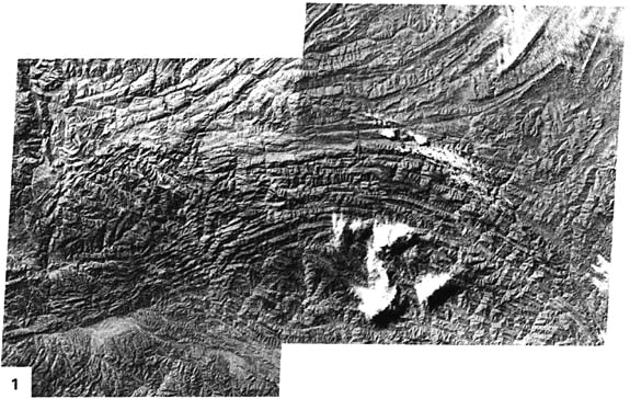
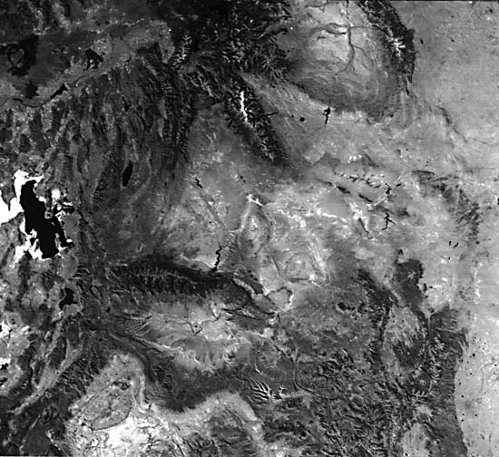
Figure T-52.1 (a join of two adjacent Landsat frames) shows the complicated structure at the northeast corner of the Sichuan basin. Tightly folded Lower Paleozoic rocks of the Tapa Shan (southern Shanxi and western Hubei Provinces) are juxtaposed with the more gently folded Mesozoic rocks of the Sichuan basin (southwest half of the left image), along a complex system of strike-slip and thrust faults (the extreme eastern end of the Altyn Tagh system). Several thrust/strike-slip faults within the Paleozoic rocks bring together divergent structural trends. The Paleozoic rocks were deformed at least once before the imposition of the current strain field. Fortuitously oriented earlier faults are still experiencing movement in the current cycle of deformation (Huang, 1978; Zhang and Liou, 1984). The famed gorges of the Yangtze River (see Figure F-16.3 and Figure F-16.4) are located near the lower edge of Figure T-52.1 and in the Plate image. The river was either superimposed on or antecedent to the complex structure.
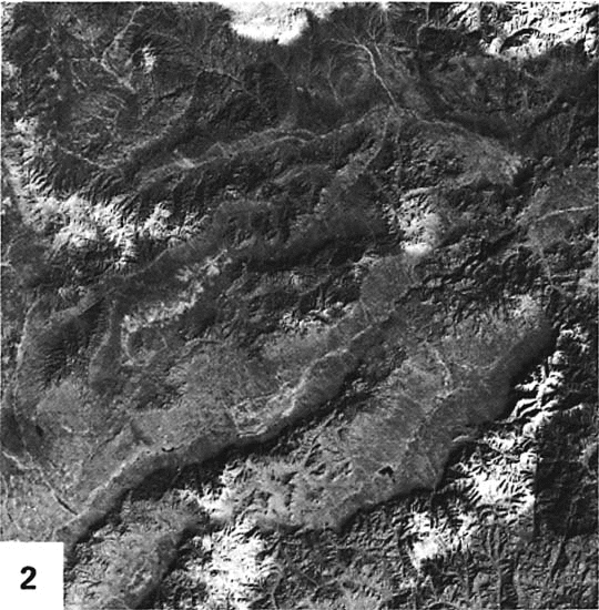
Farther to the northeast, the scene in Figure T-52.2 shows several graben of the Shanxi graben system about 1000 km north-northeast of the Sichuan basin scene and some 300 km west of Beijing. These features lie in the tensile sector of the deforming stress field north of the Altyn Tagh fault. The grabens trend northeast. The crisp appearance of many of the scarps suggests recent movement. (JRE) Landsat MSS 2305-02370, November 23, 1975.
Continue to Plate T-53| Chapter 2 table of Contents| Return to Home Page| Complete Table of Contents