 |
 |
|---|---|
| Plate T-53 | Map |
|
|
|---|---|
| Plate T-53 | Map |
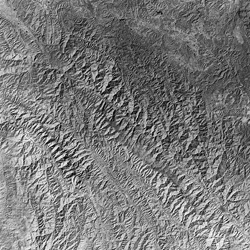
Tapponnier et al. (1982) proposed a model for the tectonic development of southeastern Asia following the Indian subcontinental collision in which they put forth a concept of propagating extrusion tectonics based on a simple experiment involving the penetration of a rigid block (representing India) into layers of plasticine in a partly confined block (Asia). As indentation proceeded, a series of criss-crossing shear faults eventually gave way to major movement of two principal fault-bounded blocks to the right (eastward) that were elongated by deformational squeezing of internal elements along faults within the blocks. The final result of the model deformation bears a remarkable resemblance to much of southwestern China and Indochina as analogs to these blocks. The two main boundary faults are likewise analogs to the left-lateral Altyn Tagh fault of Tibet (Plate T-50) and the right-lateral Red (Yuan) River fault passing through the Yunnan Province of China. Both are characterized in the model by strike-slip movement of considerable cumulative magnitude.
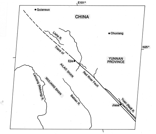
The Red River fault, crossing diagonally from upper left to lower right in this Plate, extends from the southwest edge of the Yangzi (Yangtze) Platform of north-central Yunnan in a southeasterly direction past Hanoi in Vietnam into the Gulf of Tonkin, a distance of 900 km. Although the fault is generally straight (remarkably so in this image), it bends or deflects upward (north) just to the southeast. The fault plane, where exposed, is near vertical, with subhorizontal slickensides affirming a dominant horizontal movement. On its northeast side is the Central Yunnan Swell, consisting of shallow marine sedimentary units, which is marked by a number of north-south faults; to the southwest are rocks of the Western Yunnan Province, part of the Ailao Shan metamorphic zone, cut by subparallel (northwest-trending) faults.
| Figure T-53.1 | Figure T-53.2 |
|---|---|
 |
 |
Allen et al. (1984) have studied the Red River fault system both in the field and through the use of the Plate image and other Landsat scenes. Their work confirms earlier information that movement along the fault has been dominantly right-lateral since the close of the Tertiary. The best evidence comes from offsets of tributary streams -visible with close inspection of this image- of up to 5 to 6 km in the last 2 to 3 Ma (amounting to slip rates of 2 to 5 mm/yr); earthquake focal mechanism solutions support this. No significant earthquake has occurred along this fault in the last 2000 years, which is consistent with an estimated 3000-year recurrence interval deduced from the recognition of four notable slip events recorded in Holocene deposits. Within the Plate scene, the fault has split into two subparallel segments. The main (Mid Valley) strike-slip fault lies within isolated Cenozoic river basins, and its trace has been migrating eastward. A second (Range Front) fault is coincident with the Ailao Shan Escarpment on the southwest side of the narrow river valley; curiously, this fault has a large dip-slip component.
Tapponnier et al. (1982) surmise reversal of movement on the Red River fault from the initial left-lateral sense during the first 20 to 30 Ma following the onset of the Indian collision. A different regional stress pattern now favors adjustment by dextral slip. The orientation of the fault is consistent with north-south shortening and east-west extension.
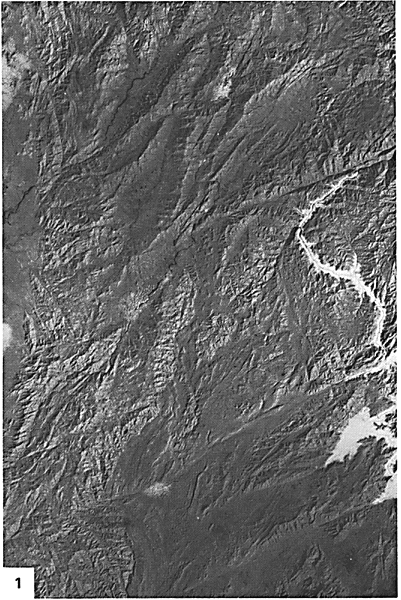
About 300 km west of the scene, along the Yunnan/Burma border, the western continuation of the mountain terrain (Figure T-53.1) is cut by a number of smaller faults and several large ones that strike east-northeast. Examination of this Landsat mosaic, but without geologic control, suggests displacement of possibly once contiguous mountain sections in a left-lateral sense. Note the ground fog in a stream valley cutting across the terrain between the two most prominent faults. The relation of these faults to the Red River fault to the east is not clear, but it is tempting to speculate on a pattern of dominant (first-order) and subsidiary (second-order) slip faults similar to that predicted by Moody and Hill (1956) in their wrench-fault model.
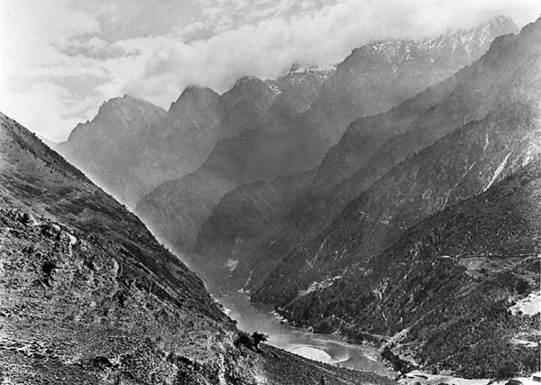
Some of the most rugged terrain in China is distributed over Yunnan Province. Figure T-53.2 shows a typical narrow river gorge (fault-controlled?) enclosed within steep-sided spurred valley walls. (NMS) Landsat MSS 1547-03112-7, January 21, 1974.
Continue to Plate T-54| Chapter 2 table of Contents| Return to Home Page| Complete Table of Contents