 |
 |
|---|---|
| Plate T-54 | Map |
|
|
|---|---|
| Plate T-54 | Map |
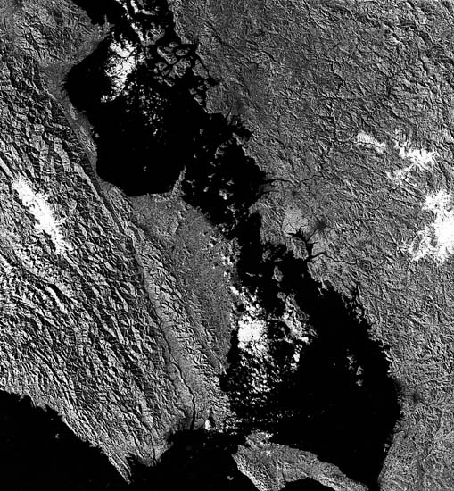
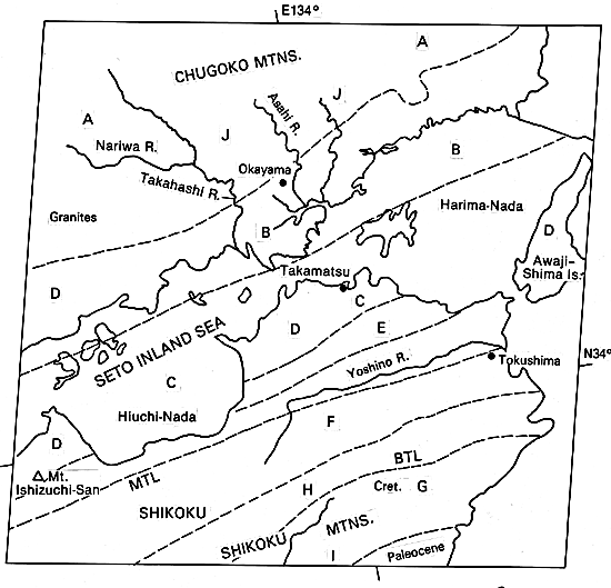
Japan consists of chains of arcuate mountains representing terranes now joined by accretion along subduction zones. Japan is an example of a complex island arc lying on the continental side of a large subduction zone (Sugimura and Uyeda, 1973). South of western Honshu, the offshore Nankai trough, a currently active subduction zone, joins the Ryukyu Trench. A second older subduction zone, the southwest Japan arc, is now a major structural and lithologic boundary that coincides with the Median Tectonic Line (MTL) separating the two major subdivisions of the western half of Japan. The MTL is not truly a "line" but the trace of a series of closely spaced parallel faults that mark the former locus of a plate convergence. The zone underwent southwest-directed thrusting and left-slip movement early in its history (Late Cretaceous), left-slip again during Mid-Tertiary, and right-slip during the Quaternary. The Yoshino River course is controlled by the MTL; southwest of the river, the MTL is marked by a fairly straight sharp scarp line along which several triangular facets can be seen, all evidence of recent movement. Terranes north of the MTL comprise the Inner Zone, composed of metasedimentary rocks (high temperature/low pressure) and intrusive of Later Paleozoic and Mesozoic age that represent the hanging wall of the subduction zone. South of the MTL is the Outer Zone of generally younger rocks, also strongly deformed, consisting mainly of low-grade (low temperature/high pressure) metasedimentary rocks that accumulated in a trench (Miyashiro, 1972; Matsuda and Uyeda, 1971). Volcanism in this part of Japan is confined to the mainland side of the MTL; no active volcanoes are present in this scene.
Geologic units in the Inner Zone are broadly arranged in three belts-the Sangun (A), the Tambia (B), and Ryoke (C) but outcrop patterns of principal units are rather irregular. Ultramafic inclusions and Cretaceous/Paleocene granitic intrusions (D) occur within these belts. The Ryoke belt here occupies a broad synclinal structure formed during the Cenozoic into which the Seto Inland Sea has invaded. A belt (E) of younger Mesozoic sedimentary rocks (marine turbidites and nonmarine facies) is juxtaposed against the MTL.
The units south of the MTL occur in well-defined belts that parallel both the MTL and the island arc/trench trend. These include the Sambagawa belt (F) which lies in fault contact with the Chichibu belt (G). Most rocks in this belt and the narrow Sambosan belt (H) have undergone folding and thrusting.
| Figure T-54.1 | Figure T-54.2 |
|---|---|
 |
 |
The Butsuzo Tectonic Line (BTL) is a structural boundary that separates the Honshu depositional basin from the Late Mesozoic/Paleocene Shimanto basin (I). Near the BTL, rocks are principally Cretaceous eugeosynclinal deposits of marine clastics and submarine volcanic flows. Paleocene sedimentary rocks, also deformed, make up most of the southern third of Shikoku Island.
Japan has therefore been the locus of two major continental margin deposition basins now juxtaposed by plate convergence and strike-slip faulting. Orogenic activity has climaxed several times- Late Paleozoic (Abean orogeny), Early Mesozoic (Akiyoshi orogeny), Late Mesozoic (Sakawa orogeny), Late Cenozoic (Takachiko orogeny), and the Recent.
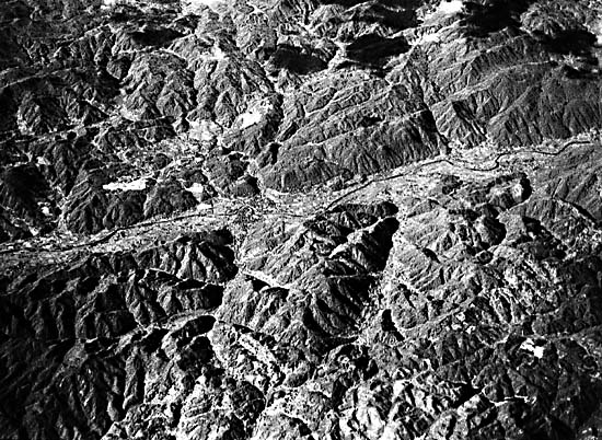
Present topography clearly reflects differences in underlying rocks and major structural features. The strongly linear topographic grain of the Outer Zone suggests both strong folding and strike-slip faulting. The rugged topography indicates recent uplift, and the extremely straight crisp appearance of several river valleys implies recent strike-slip fault movement. Topographic texture adjacent to the flats at the northeast end of Shikoku is interpreted to mean that at least some of the recent movement is right-lateral. Denudation rates are high (up to 1 m/1000 years) in parts of the Outer Zone. Mountains of the zone in this scene are characterized by pronounced linear crest lines and high relief. Most crests trending northeast are approximately parallel to the boundaries of the stratigraphic and metamorphic belts on which they develop. The relatively easily eroded granitic rocks just north of the MTL are areas of low relief. Figure T-54.1 is an aerial view looking southwest at the broad plains inland from the Seto Sea in central Shikoku, against which rise the triangular-faceted fault scarp of the MTL and the high mountains of the Sambagawa belt.
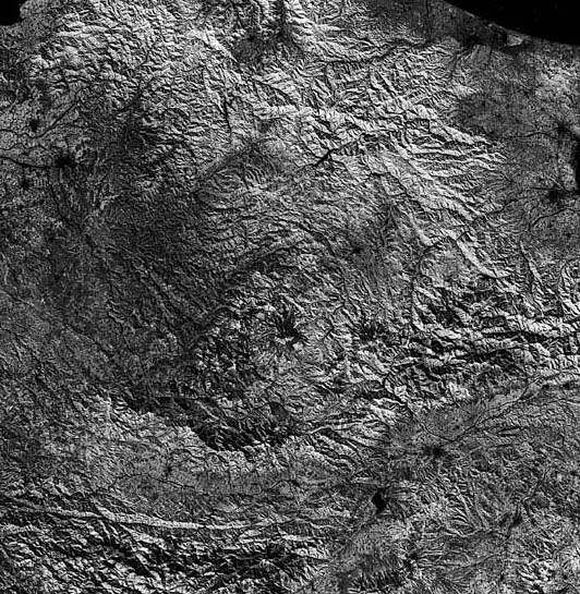
In the Inner Zone, mountains of more subdued relief, expressing denudation at a much slower rate, lack well-defined crests and peaks. Fracture zones, some of which are also faults, produce long narrow valleys (J) and appear to control some of the meandering deflections of several major streams such as the Ashi River. The less "organized" texture of the topography in this zone probably reflects the greater metamorphic homogenization of the rocks. Such topography is evident in Figure T-54.2, a view of granitic rocks in the Tambia belt.
| Figure T-54.3 |
|---|
 |
The eastern end of the southwest Japan structural division is shown from Landsat in Figure T-54.3. The region here includes the fringe of Nagoya (lower left) to Takaoka and Toyama (top left) and Matsumoto (east). The Fossa Magna (see Plate V-24) that divides the belts running subparallel to the coastlines in southwest Japan from the northeast Japan division lies along the east side of the image. Zones 2 (Sangun) and 3 (Ryoke), seen in the Plate, continue up to this fault-controlled boundary. Zone 1, the Hida Zone (not present in the Seto Sea region), occupies the upper third of Figure T-54.3. (NMS) Additional References: Moore and Karig (1976), Shimazaki (1976), Tanaka and Nozawa (1971), Uyeda and Miyashiro (1974), Yoshida (1975), Yoshikawa et al. (1981). Landsat 1112-01120-7, November 12, 1972.
Continue to Plate T-55| Chapter 2 table of Contents| Return to Home Page| Complete Table of Contents