 |
 |
|---|---|
| Plate V-10 | Map |
|
|
|---|---|
| Plate V-10 | Map |
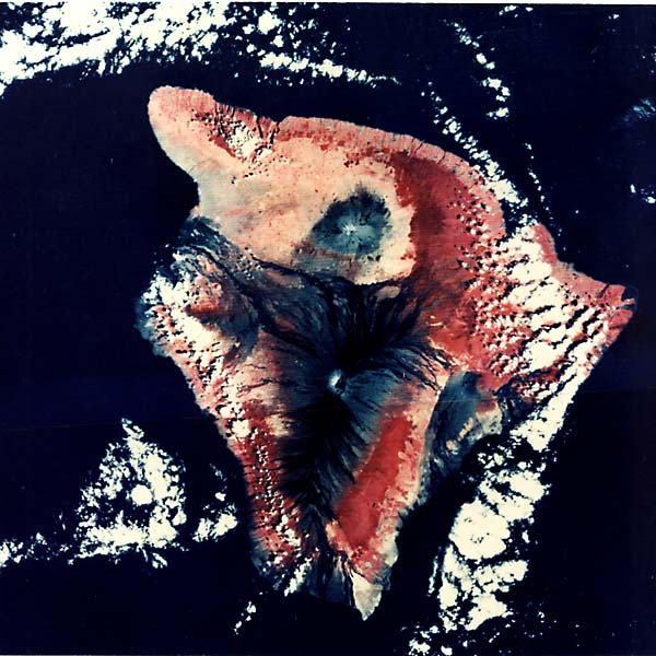
An impressive landform when seen from space, Hawaii is famous not only for its esthetic beauty, but also as the largest shield volcano complex on Earth. Its subaerial landmass rises 4135m above sea level to its present elevation; it also extends 4900 m below the waves to the ocean floor. It is 140 km wide at sea level and even wider at its base and is aptly called the "Big Island. "
Hawaii is at the southeastern end of a striking geographical and geologic feature, the Hawaiian archipelago. This consists of a broadly linear chain of more than 50 volcanic islands and submerged mountains stretching 4000 km northwest from Hawaii itself past Midway Island to the Emperor Seamounts, a chain of about 30 submerged volcanoes (Stearns, 1966). These seamounts form an "elbow" with the Hawaiian volcanic chain and then trend north-south for 4800 km, disappearing to the north in the Kamchatka Trench. The 80 or so volcanoes in these two chains came into existence more or less sequentially. Radiometric dating shows ages exceeding 70 million years for the oldest seamounts, but the Hawaiian Islands are far younger. Hawaii, the only island with volcanoes that are active in this century, is the youngest major volcanic pile, with ages under 700000 years. (Maui has experienced activity in historic times.) Moving north-westward along the chain, the islands become progressively more weathered and decomposed.
Jason Morgan (197 1) suggested that the cause or source of these shield volcanoes was a stationary hotspot in the Earth's mantle that created rising columns or plumes of hot light material that broke through weak places in the crust. The Pacific plate on which these volcanoes are built has slowly moved west over the hotspot, leaving a trail of volcanic islands. The bend in the chain where the Emperor Seamounts appear represents a direction change of the plate some 40 Ma ago.
| Figure V-10.1 | Figure V-10.2 |
|---|---|
 |
 |
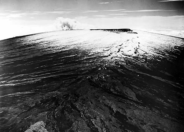
A shield volcano is defined as a great pile of lava flows, normally composed of basaltic rocks, whose gentle slopes (2 to 10°, downward from a central highpoint give it a profile likened to a warrior's shield resting face up -well illustrated by Hawaii (Figure V-10.1). Thousands of layers of tholeiitic lava (higher in silica and lower in alkalis than average basalt) were laid down on the ocean floor until Hawaii reached its present height. This lava, not viscous enough to form steep cones, spread out at high flow rates from narrow surface fissures (rifts) that opened as pressure built up in the subterranean magma chambers.
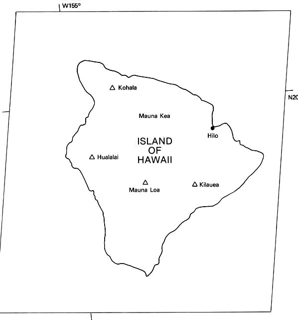
The island of Hawaii, amalgamated by the coalescence of five smaller shield volcanoes (most of the chain islands are composites), lies near the present position of the hotspot today (possibly under Loihi to the southeast). In chronological order, these volcanoes are: Kohala, Hualalai, Mauna Kea, Mauna Loa, and Kilauea. Erosion has already affected Kohala, but at Landsat MSS resolution, the others appear relatively fresh. The three oldest are apparently extinct, but the last two are very active; in fact, a recent major simultaneous eruption of Mauna Loa and Kilauea (a rare double event) occurred in March-April of 1984.
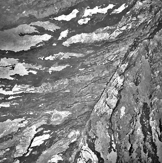
Many eruptive events on Hawaii over the last few millennia can be seen from space as light (older, more weathered) and darker (younger, fresher) streaks on its surface (Carr and Greeley, 1980). Most large dark lava flows along the flanks of Mauna Loa have happened in the last 150 years. Most Holocene eruptions of Mauna Loa take place as flank flows along rift zones (Figure V-10.2) identifiable at the surface as open fissures and by alignment of cinder and spatter cones constructed by episodic lava fountains. A huge oval steep-walled caldera, Mokuaweoweo, was formed by collapse at Mauna Loa's summit.
| Figure V-10.3 |
|---|
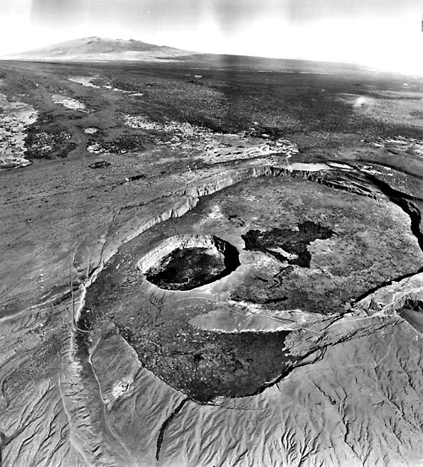 |
Directly to the east of Mauna Loa, a linear seam reveals where Kilauea has been welded to Mauna Loa as it grew. It was added primarily by eruptions from two rift zones, southwestward and eastward from its summit crater (Figure V-10.3). In the image, Kilauea's caldera stands out as an oval shape between dark lava streaks. The caldera formed by collapse of the volcanic pile along ring faults over a shallow magma chamber. Dark dots in the oval represent pit craters on the floor. The pit crater nearest the southwestern edge is Halemaumau (House of Everlasting Fire), which from time to time has contained a lake of boiling lava. Halemaumau is the traditional home of Madame Pele, the Hawaiian goddess of volcanoes. Residents of the island make offerings of her favorite drink, gin, to appease her and save their properties during threatening eruptions. Past eruptions of Kilauea varied from lava lakes in Halemaumau through short-lived lava flows within the crater or flank flows from fissures along the rift zones passing across the volcano. Spectacular lava fountains develop along these zones, sometimes reaching heights of 500 m or more (MacDonald, 1972). Occasionally, seepage of ground water into underlying heated rocks causes steam eruptions. Prepared by Mary M. Kennedy. Text modified from comments by R. Greeley, Arizona State University. Additional References: Greeley (1974) and Macdonald and Hubbard (1970). Landsat Mosaic.
Continue to Plate V-11| Chapter 3 Table of Contents.| Return to Home Page| Complete Table of Contents