 |
|---|
| Plate V-17 |
|
|---|
| Plate V-17 |
As stated in the introduction, most of the active volcanoes worldwide lie along the convergent margins of the Pacific Ring of Fire or along the network of spreading ridges that traverse the oceans. Another great line of convergence is marked by the Alpine/Himalayan belt system along which at least four major plates continue to move against one another. Surprisingly, Neogene volcanism throughout this belt has been relatively sparse compared with the Pacific Ring. In the Mediterranean region, only a few volcanoes are active today, mainly in and around Italy, with other centers in France, Germany, and the Aegean Islands. At its eastern end, now extinct but apparently recent volcanoes have been discovered (some through Landsat) on the Tibetan Plateau north of the high Himalayas. A third of sporadic activity extends from Armenia in eastern Turkey eastward through the Central Volcanic Belt of Iran (Boccaletti et al., 1977).
This region is located mainly within a zone of intense lithospheric crushing where the Arabian Plate is moving northeast against the Eurasian Plate (see Plate T-39). On the west and east sides of the point of convergence near Lake Van are two other plates, the Anatolian and the Iranian, which are considered rnicroplates by some tectonicists. The Anatolian Plate is being squeezed westward along the North and East Anatolian transcurrent faults. Likewise, the Iranian Plate is being pushed to the southeast along similar faults that pass through the Elburz Mountains north of Tehran and through the suture (Main Recent Fault) of the Zagros Crush Zone. Some of this deformation began in Late Cretaceous/ Paleocene times, intensified in the Miocene/Pliocene, and continues unabated.
| Figure V-17.1 | Figure V-17.2 |
|---|---|
 |
 |
Lambert et al. (1974) studied the tectonic, petrologic, and geochemical setting of the region that encloses Mt. Ararat, a large stratocone (more than 35 km wide at ground base) near the corner at which Turkey, Iran, and Soviet Armenia meet. Here, in the aforementioned crush zone (considered a discrete microplate --the Van plate--by Dewey et al. (1973)), crustal shortening along a northeast line gives rise to a northwest tensional line of fractures that control volcanic emplacement. This group includes Nemrud at the west end of Lake Van, Suphan, Tendurek, and Ararat itself at the northeast end. The crush zone sits astride the intersection between east- west tectonic trends in Turkey and the northwest-southeast Zagros structures (Plate T-42). Dewey et al. (1973) and other investigators postulate consumption of the Arabian Plate along a subduction zone under the Van microplate. Lambert et al. (1974) and McKenzie (1972) point to the absence of intermediate to deep earthquakes as evidence against subduction today.
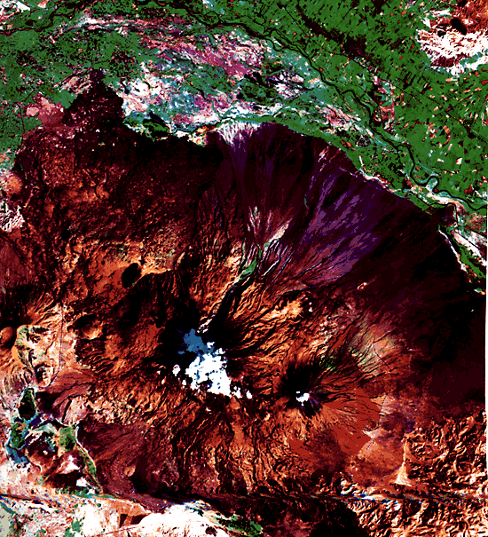
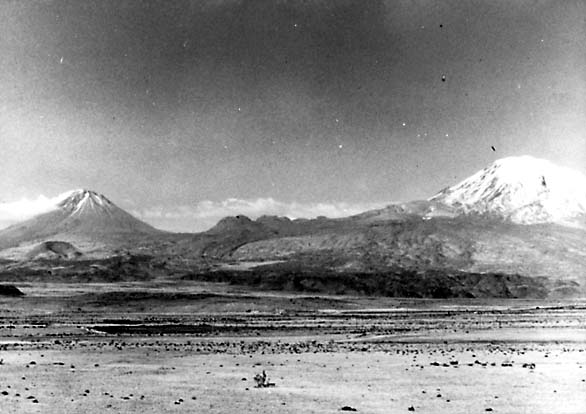
Highest of the northeast line of volcanoes is Ararat (Altinli, 1964). As seen (looking southward) from the ground (Figure V-17.1), Greater Ararat (right) at 5156 m towers above Little Ararat (3903 m) some 12 km to the east. Both peaks are evident in the thematic mapper subscene that constitutes Plate V-17. This unusual color rendition results from a combination of bands 1 (blue), 4 (green), and 7 (red). This effectively separates clouds above Greater Ararat from an ice cap (in blue), both of which appear white in visible wavelength images. Much of the lava and ash deposits along the slopes appears as a purplish-brown (as does some derivative Quaternary slope debris). Some of the younger basalts to the northeast take on a purplish-blue hue. Bright red markings superficially resemble fresh lava flows but are brush fire burn scars (bright in band 7). Older tuffs exposed in the Cehenna Gorge cut into the north flank are not recognizable, being largely in shadow, but still older volcanics to the west are rendered yellow-brown. The darker orange-brown along the upper slopes of Ararat results from the color mix related to bright returns from vegetation (forests) for band 4 and rock and vegetation for band 7. Especially distinctive in the image are lava channels and gutters; adventive cones and possibly domes may also be present on the slopes. Dissected volcanic terrain gives way to a plains along the Rizdan River to the north and to Devonian/Permian sedimentary rocks in mountains to the southeast.
| Figure V-17.3 |
|---|
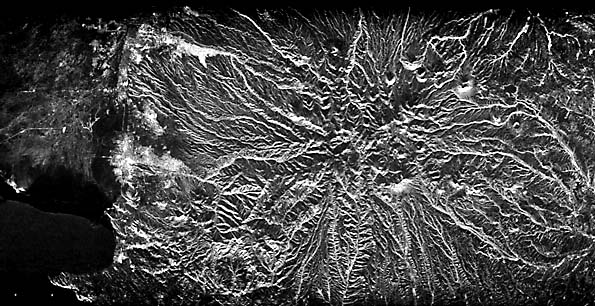 |
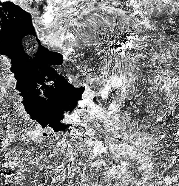
Ararat is typical of the calc-alkaline volcanism that led to the expulsion of dacites and andesites in the region. Younger out-pourings consist of alkali basalts. Related volcanism extends eastward into northern Iran, culminating in the dormant Damavand (5671 m) volcano near Tehran. Another large stratovolcano, Sahand (3710 m) south of Tabriz, is prominent in the Landsat image shown as Figure V-17.2; a smaller volcanic structure, Shaki (2189 m), extends as a peninsula into Lake Urmia. Both show extensive slope erosion, forming barrancos or gorges that help to emphasize the pronounced radial drainage. This pattern is especially brought out in the SIR-A radar image of Sahand seen in Figure V-17.3. Landsat TM 50209-07140, September 9, 1984.
Continue to Plate V-18| Chapter 3 Table of Contents.| Return to Home Page| Complete Table of Contents