 |
 |
|---|---|
| Plate V-18 | Map |
|
|
|---|---|
| Plate V-18 | Map |
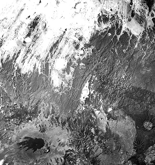
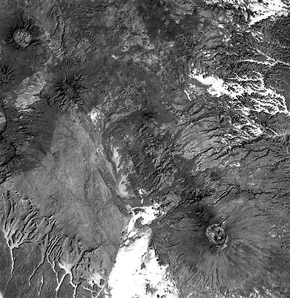
The Tibesti Massif in northern Chad (Vincent, 1970) is a large epeirogenetically uplifted crustal block of Precambrian crystalline rocks capped by Cenozoic volcanic flows and pyroclastic deposits. The present topography (Figure V-18.1) of the Tibesti complex is one of stepped plateaus, low dissected ridges cut into volcanics, and volcanic cones with minimum slopes of 2 to 4° and seldom exceeding 15° (Prichard, 1979). The entire massif now extends over 100 000 km2, of which about 30 000 km2 consist of volcanic rocks. The older Precambrian units (A) contain migmatites and granitic intrusions within metamorphic complexes. The more widespread younger Precambrian (B) is a collection of quartzites and phyllites. Sandstones dominate an unconformable Lower Paleozoic sequence that spreads around the periphery of the Tibesti Plateau (C). A Nubian sandstone unit (D) of Early Cretaceous age lies along the edge of the crystalline basement. The massif has been intermittently raised, with arching of overlying sedimentary units, since Mid-Paleozoic times. Later, sets of northeast and north-northeast faults (E), following Pre-Cambrian trends, cut these units. The structure, then, is that of a major block broken by several horst/graben segments, tilted north-northeast, and capped by a broad flexure with a northwest-trending axis.
Intense volcanic activity began in the region during the Early Tertiary. One view holds that the Tibesti volcanoes represent continental volcanism over a hotspot tied to a deep-seated mantle plume. In several respects, the volcanic complex can be compared as a continental analog to the Island of Hawaii, although there are considerable petrologic differences. A great pile of plateau flows forms the volcanic base on which shield-like volcanoes, some made of ignimbrites intercalated with basalt flows and most topped by calderas, are superposed. Volcanism was quite active during the Quaternary, with numerous explosive ejections of pyroclastics, but currently the activity has abated so that only one volcano, presently dormant, has shown recent stirrings.
| Figure V-18.1 | Figure V-18.2 |
|---|---|
 |
 |
The oldest volcanics, the First Black Series, are alkaline olivine basalts that flooded the terrain. Associated trachytes and phonolites form plugs. Later, the Second Black Series, mostly tholeiitic basalts with alkaline rhyolites, built up the shield volcanoes (Toon, Oyoye, and Yega), together with rhyolitic elevated domes (Abeki) and cumulo-domes (Sosso) of viscous rhyolitic glass. Another type of volcano, called a "shield sheet," is represented by Tarso Voon. This unusual structure consists of a wide apron of poorly indurated pumiceous pyroclastic deposits (sillars) that extend without an apparent "root" (vent channel) across previously valley terrain and pinch out laterally from a deeper center (Vincent, 1970). Within this cupola- like structure, a large (18 by 11 km) summit caldera collapsed into the central interior.
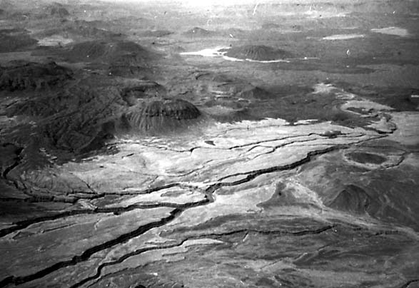
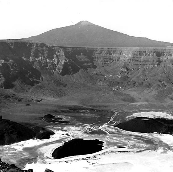
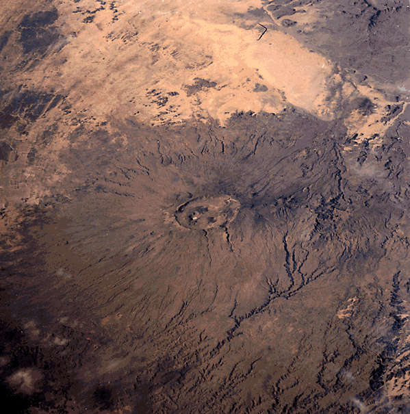
The most recent volcanism added both alkali basalts and trachyandesites to the surface. The distinctive dark pattern around Tousside (possibly still active; 3265 m high) associates with a fresh low-reflectance surface composed of trachyandesitic ignimbrites with some flows. Nearby is the smaller explosion-collapse caldera (8 by 6 km) atop the Trou au Natron, on whose floor are deposits of sodium carbonate (natronite) surrounding small cones (Figure V-18.2; Green and Short, 1971). At the southeast end of the volcanic terrain stand the massive Emi Koussi (Figure V-18.3), largest and highest (3415 m) of the central caldera volcanoes from which pyroclastic deposits have spread outward many kilometers. In the same image is the older, more dissected Tieroko Volcano. As photographed by an astronaut during the STS-17 (Shuttle) Mission, Emi Koussi (Figure V-18.4; north to right) bears a striking resemblance to Klysium Mons and, to a lesser extent, Olympus Mons on Mars (Plate P-6; Malin, 1976).
| Figure V-18.3 | Figure V-18.4 |
|---|---|
 |
 |
Several of the volcanoes, particularly Toon and Abeki, show a concentration of feeders along boundary faults within and beneath the walls of their calderas. These are analogous to the classic cone-sheet structures described by Anderson (1936) for Scottish volcanic roots. The faults are directed inward and steepen with depth, producing a convergent feeder system. Radial dikes also occur in these structures.
Volcanism began as the region underwent flexuring in the Mid-Eocene. Tensional fractures parallel to a northwest flexure axis, and probably controlled in part by basement lineaments, localized the feeders. The NNE-NE fracture systems did not serve to channel the lavas. Sources of the older alkaline lavas and the younger tholeiites were probably independent of each other and came from different depths. The rhyolites are believed to have resulted from partial fusion of the crust rather than direct differentiation. Although the older basalts are widespread in this part of Africa, being found at the Haroudj and Eghei and elsewhere, the rhyolites are confined to the Tibesti region. Landsat 2367-08343-7, January 26, 1976.
Continue to Plate V-19| Chapter 3 Table of Contents.| Return to Home Page| Complete Table of Contents