 |
 |
|---|---|
| Plate V-3 | Map |
|
|
|---|---|
| Plate V-3 | Map |
Late Cenozoic volcanism along the southern margin of the Colorado Plateau (Eastwood, 1974) produced two of the finest examples of small volcanic fields in the western United States. Large parts of each-the San Francisco and the Hopi Buttes fields-are portrayed in the lower half of the Plate image.
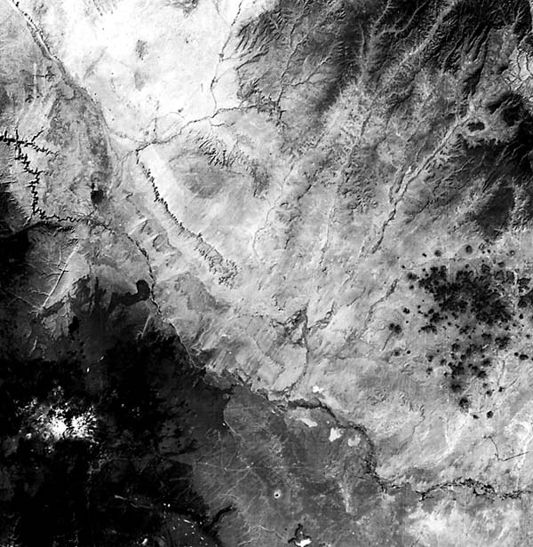
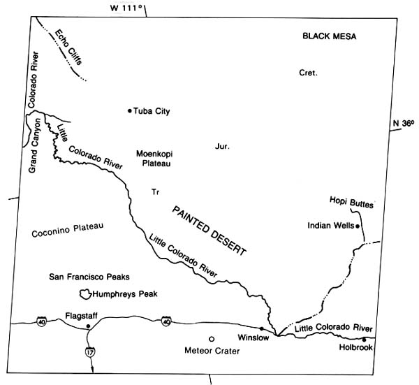
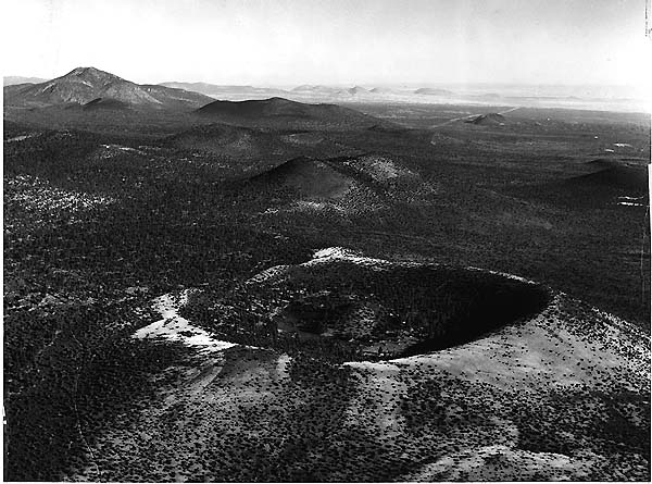
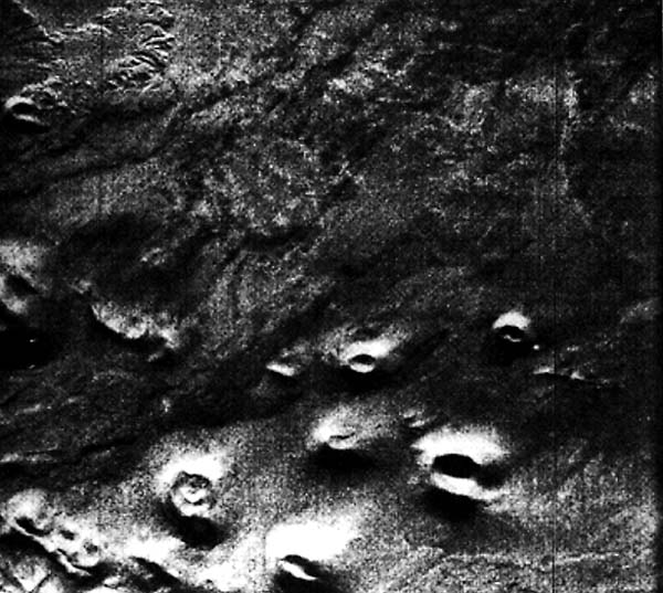
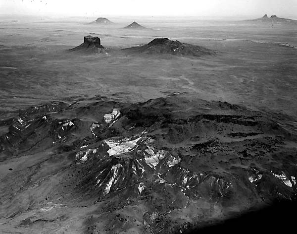
The San Francisco field (Moore et al., 1974; Updike, 1974) extends over 5000 km2 in a section of the Plateau around Flagstaff, Arizona, capped by Permian sedimentary rocks. Three segments of volcanic outflows center around the San Francisco Peaks. The best studied of these segments lies east and north of the peaks. There, more than 175 individual cinder cones and associated flow units have developed during the last 6 Ma. These cones exhibit considerable variations in shape and height, depending both on the original morphology after they had completed their active phase and on subsequent erosive degradation. Figure V-3.1 offers a typical panorama of the cinder-cone field in the northeast. Many of the cones appear to be aligned in a north- northeast trend followed by the conspicuous graben at the north end of the Mesa Butte fault, one of several in the region that that lineament control (ultimately in the basement rocks) has governed emplacement of magmas probably derived from mantle sources. This figure also depicts a second morphologic type, the maar depression, represented by Moon Crater in the foreground. The appearance of several cones is splendidly defined in an X- band radar image (Figure V-3.2) taken from an aircraft. The northern part of the field was also imaged by the L-band radar on Seasat. Tonal differences are correlated to some extent with the several ages of the flows; bright tones indicate considerable backscatter from rough fresh surfaces such as SP Crater (S on Figure V-3.3), one of the youngest in the field. Note that the nearby older flow at Black Point (B on Figure V-3.3) reflects as a darker tone that affords less contrast with other flows and surface gravels and alluvium.
| Figure V-3.1 | Figure V-3.2 |
|---|---|
 |
 |
Five episodes of volcanism have been identified and dated radiometrically, beginning about 5.5 million years ago and apparently ending in the last 1000 years (Moore et al., 1974). The principal outpourings are alkali olivine basalts. Consanguineous differentiates emplaced mainly in the last 0.7 to 0.2 Ma include andesites, rhyodacites, and rhyolites, extruded as domes, some breaking on the surface as flows and pyroclastic deposits. One of several silicic eruptive centers is at O'Leary Peak (upper left in Figure V-3.1); nearer to Flagstaff, a much larger silicic volcano has formed the present San Francisco Mountains, now somewhat eroded by glaciation. A second center is at Elden Mountain, south of Humphreys Peak.
In this image, one can readily see Meteor Crater, a prominent white dot (sedimentary ejecta blanket surrounding the 1.4 km wide central depression). This impact structure is less than 25000 years old.
The Hopi Butte volcanic field (Sutton, 1974; Williams, 1936) stands out against a background of the Late Miocene/ Early Pliocene Bidahochi Formation, a fluviatile-lacustrine deposit resting on Mesozoic strata in the Painted Desert south of the Cretaceous uplands of Black Mesa. This roughly circular (radius ~30 km) field encloses about 200 individual eruptive centers, most isolated from one another (Figure V-3.4). Most prevalent are necks and plugs of volcanic rocks, now exposed as resistant central cores surrounded by remnants of sedimentary rocks and talus slopes. Buttes of sedimentary rock and volcanic ash capped by lava flow remnants are also common. A few maar craters are scattered through the cluster. Dikes, sills, and domes are also found in the field.
| Figure V-3.3 | Figure V-3.4 |
|---|---|
 |
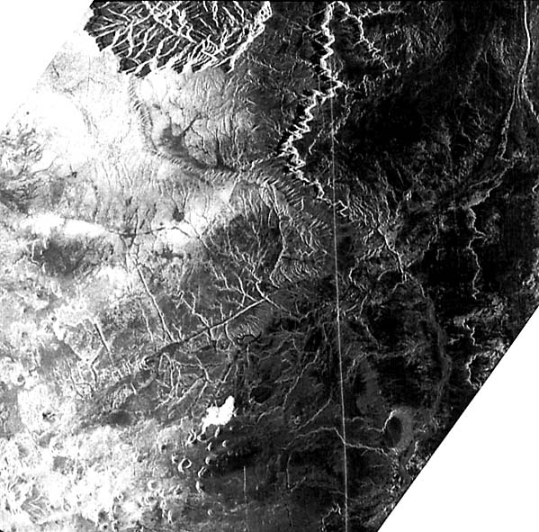 |
These volcanic features are related to a swarm of diatreme pipes tapping deep below the crust to bring up explosively expelled basic rocks. These rocks are chiefly alkalic lamprophyres (limburgite and monchiquite) that contain olivine, titanaugite, and analcime. During part of their activity, some diatremes erupted into lakes, and maar-type craters were formed. Erosion by the Little Colorado River has stripped away most of the cover, leaving exposed butte-like vent-fill pipes along several levels of valley terracing. Again, lineaments serve to localize the volcanic activity along two prominent northeast and northwest trends.
Note a faint, but traceable northeast streaked pattern on the Painted Desert bench surfaces. This also is suggested by notched indentations along the Echo Cliffs near Tuba City. The surface pattern seems to be affected by prevailing winds; the notch indentations may be a response of joint orientations to wind- affected erosion. Landsat 1103-17323-5, November 3, 1972.
Continue to Plate V-4| Chapter 3 Table of Contents.| Return to Home Page| Complete Table of Contents