 |
 |
|---|---|
| Plate F-21 | Map |
|
|
|---|---|
| Plate F-21 | Map |
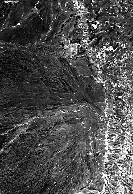
The rivers in this Landsat two-scene mosaic are tributaries to the Paraguay River in the Brazilian state of Mato Grosso (Holz et al., 1979). This portion of west- central Brazil lies in the savanna climatic zone south of the great Amazon rain forests. Mean annual rainfall is approximately 1250 mm, with one-half generally coming in the summer wet season. Harsh temperatures, poor soils, and periodic extensive flooding result in a low population density. Principal land use consists of grazing and subsistence agriculture. There are no major towns in this scene.
The scene is separated into two physiographic regions (Pantanal Plains on west; Central Plateau) by a prominent escarpment of the Devonian Chapada Group sandstones that underlie the Paraná sedimentary basin to the east. West of the escarpment is the Pantanal Basin, which is underlain by up to 100 m of Quaternary alluvial deposits covering post- Triassic sedimentary rocks. Streams crossing the escarpment, known locally as Serra de São Lourenço, fall several hundred meters from the plateau upland to the basin floor. Gradients of 0.5 to 1.5 m/km occur at the escarpment, while gradients of 0.01 m/km characterize rivers in the Pantanal Basin.
The Brazilian Ministry of Interior reports a maximum daily discharge of the Rio Piquiri immediately west of this scene at 405 m3/s. The minimum daily discharge was 73 m3/s, and the mean annual discharge is 131 m3/s for gage records in 1968-1971. Despite the pronounced seasonality of the climate, baseflow is maintained in the eastern Pantanal rivers through ground- water discharge fromextensive sandstone aquifers.
The most striking fluvial features in this image are the great alluvial fans that lie immediately west of the Serra de São Lourenço. The largest of these is related to the Rio Taquari, which appears in the lower part of the mosaic. The Taquari fan covers an area of approximately 50000 km2, only part of which is shown in the lower part of this image. Portions of the smaller São Lourenço fan are visible at the top of the picture. These fans consist of sands derived from the Paraná Basin and deposited by low-sinuosity anastomosing channel systems in the relatively recent geologic past (Holz et al., 1979). Note that the modern active rivers crossing the escarpment have high-sinuosity meandering patterns. Their clearly defined floodplains are a marked contrast to the splaying pattern of ancient paleochannels.
This mosaic shows the sinuous Rio Taquari emerging from the escarpment just west of the town of Coxim. Note the splaying pattern of paleochannels developed to the southwest of the Rio Taquari. Crosscutting relationships indicate a succession of channel abandonment on the fan surface.
| Figure F-21.1 | Figure F-21.2 |
|---|---|
 |
 |
Note the decrease in sinuosity for the Rio Taquari in a downstream direction (right to left). This occurs because of decreasing mean annual flow and increasing flow variability in the downstream direction. Water is lost by infiltration into the sandy fan sediments underlying the river. This recharge feeds an extensive ground- water system that is directed toward the Paraguay River 200 km to the west.
The pronounced differences in channel patterns for this region probably resulted from Quaternary climatic change. During the glacial conditions that characterized much of the Quaternary, the climate of this region likely changed from its present tropical savanna conditions to semiarid conditions. The modern Brazilian savanna vegetation, known as "Cerrado," was replaced with xeric plants that were less capable of preventing erosion on interfluves. Stream regimens probably changed from their present uniformity to ephemeral conditions characterized by rare but intense floods that carried immense loads of sand washed from adjacent slopes. The sediment-charged streams deposited their load on the immense fans along the Pantanal escarpment. The subsequent climatic change to interglacial time resulted in a shift to modern channel conditions. The expansion of savanna vegetation resulted in greater protection of slopes from erosion. Somewhat more uniform and wetter climatic conditions facilitated the present flow regimen of the rivers. Present stream loads are dominated by suspended fines, and the appropriate channel pattern is that of a through-going meandering stream.
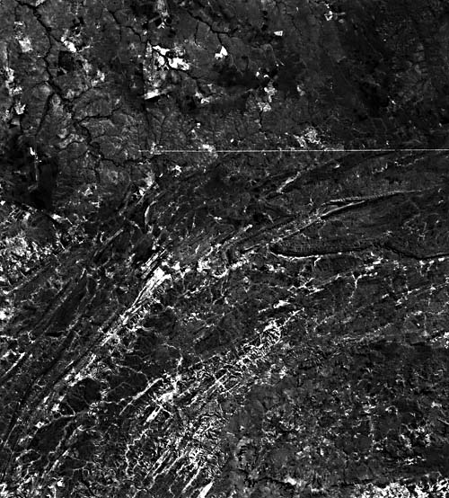
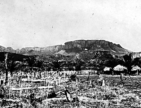
The escarpment cut from the Central Plateau continues northward farther into Mato Grosso until it encounters exhumed Precambrian rocks around the Cuiabá River (Figure F-21.1 and Figure F-21.2 (scarp of the Serra do Aquapei)). These rocks, consisting of molasse metasediments and igneous-metamorphic complexes, are strongly deformed (note anticlines near right side of the image). Post-Paleozoic units lie against this orogenic belt along its north side. The Rio Arinos drains northward into the Amazon Basin from the Planalto do Mato Grosso; the Rio Cuiabá moves southward from the divide into the Paraguay and ultimately the Paraná rivers. Landsat 281149-125759-7, May 29, 1981.
Continue to Plate F-22| Chapter 4 Table of Contents.| Return to Home Page| Complete Table of Contents|