 |
 |
|---|---|
| Plate D-11 | Map |
|
|
|---|---|
| Plate D-11 | Map |
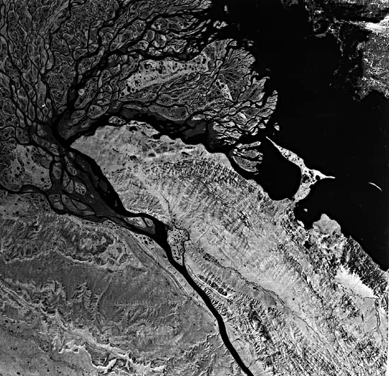
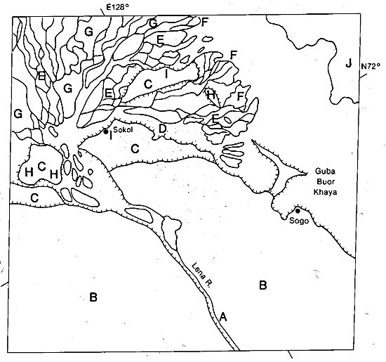
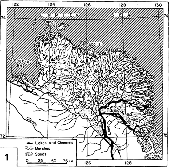
The Lena River, with a length of 4250 km, is the longest river in the U.S.S.R. A great delta has formed where it empties into the Laptev Sea, a part of the Arctic Ocean (Figure D-11.1) (Suslov, 1961). The river rises a few kilometers west of Lake Baikal, on the western slopes of the Baikal Mountains, at an elevation of 1800 m. Throughout much of its course, the river widens into broad braided stretches 3 to 4 km wide and then narrows as it cuts through more resistant strata. Near its delta, the river narrows considerably (A) as it cuts through the Kara Ulak Mountains (B), which are composed of Permian and Cretaceous sediments. Even in this stretch, narrow Pleistocene river terraces are present along the Lena's course. Its drainage basin area is quite large at 2 478 000 km2. To the south of the delta, the basin waters tend to thaw and deliver their sediment-water discharge prior to breakup in the delta region. This melting results in extremely large numbers of ice jams and very high water levels along the river's course, as well as in the delta proper. Thus, the discharge is extremely erratic; average discharge is 50 870 m3/sec, but the maximum discharge is 393 850 m3/sec (Samajlov, 1956).
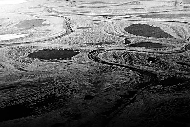
Emerging from the highlands, this long north-flowing river crosses the taiga of Siberia, one of the most extensive forests on the Earth. After passing through the narrow gorge near its delta, the Lena cuts through broad coastal Pleistocene terraces (C), many remnants of which are present as isolated highs within the delta. The fan-shaped delta covers some 28 500 km2 and is a maze of small distributaries. The river splits off into several distributaries, the only one of significance being the Trotimorskaya, which flows into the eastern part of the delta. The delta can be divided generally into two major parts, the western delta and the eastern delta (Antonov, 1959). The western delta (not shown on the satellite image) is relatively high, is moderately crossed by distributary channels, and has had many of its lakes tapped and drained, resulting in dry land or former lake surface over approximately 85 percent of the delta. The presently more active eastern part of the delta is characterized by relatively low elevations and a large number of anastomosing channels and sand bars. In both parts of the delta, the ground is permanently frozen, often to depths in excess of 15 m.
| Figure D-11.1 | Figure D-11.2 |
|---|---|
 |
 |
At the apex of the delta, the Lena River is complexly braided (D), with many large braid bars and small channels. Within the delta plain, the major channels split and rejoin, forming a maze of anastomosing channels; see (E) and Figure D-11.2 (Suslov, 1961). Near the distal ends of the distributaries, where the channels often broaden out, the river mouth bars (F) are composed of barren sand and mudflats. Tidal range is low, generally less than 40 cm, and does not significantly influence the sediment distribution pattern. Wave action at the coast can be considerable, with wave heights up to 2.5 m being quite common. As a result, small beaches and complex offshore barriers are present at most of the river mouths of arctic deltas; see Figure D-11.3, showing the Colville Delta, Alaska, U.S.A. The channels in the lower delta are often quite deep, on the order of 15 to 18 m, being much deeper than the upstream segments. Sediment load is quite high during the short flood season, with the suspended load reaching 11.7 million tons per year. Offshore currents are relatively low and generally flow to the northwest, carrying large quantities of fine-grained sediment westward along the coast.
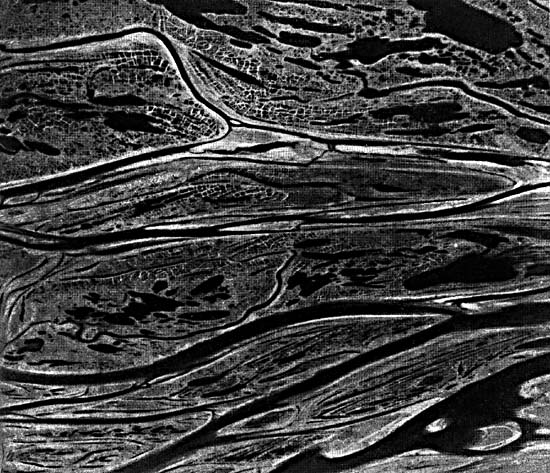
The delta plain (Figure D-11.4) consists of a maze of anastomosing channels, between which are broad areas of tundra surfaces containing patterned ground (Figure D-11.4) or polygons, freshwater lakes, and overbank splays (G). The tundra surface is composed of relatively large and complex patterned ground, which results from the annual freezing and thawing process. Ice wedges and other similar arctic landforms are present. As a result of thawing, many small freshwater lakes now dot the tundra surface. Because ice jams in the distributary channels cause abnormally high water in the delta, overbank splays are quite common, often filling many of the small lakes. After the major flood has subsided, water levels drop considerably, exposing a large number of sandy midchannel bars. Wind erosion removes the finer sands and forms small oriented dunes along the channel margins, often extending onto the adjacent tundra surface and into the lakes. The river traverses large taiga forests and thus carries large quantities of woody debris. This organic debris is often left stranded on the midchannel bars and within the channels.
| Figure D-11.3 | Figure D-11.4 |
|---|---|
 |
 |
On the Pleistocene surface (G), oriented lakes (H) are present, similar to those found along most of the Arctic tundra. Pingos (I) or "ice-core hills" are also found on this surface. Broken pack ice (J), which is nearly always present, can be seen offshore of the delta.
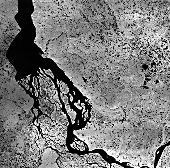
The third (largest) of the tundra deltas in the U.S.S.R. is that of the Yenisey River (Figure D-11.4, a Landsat scene), some 1200 km to the west where it empties into the Kara Sea. There, the delta (about one-tenth the area of the Lena delta) lies at the inner end of a narrow gulf and thus does not fan out like the Lena. Landsat 1368-03062-7, July 26, 1973.
Continue to Plate D-12| Chapter 5 Table of Contents| Return to Home Page| Complete Table of Contents|