 |
 |
|---|---|
| Plate D-7 | Map |
|
|
|---|---|
| Plate D-7 | Map |
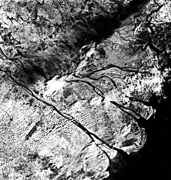
The Mekong River is one of the larger rivers in southeast Asia. The river's headwaters are located in the Tibetan Plateau and cover an area of 800 000 km2. From its source in southern Quinghai Province of China, the Mekong follows a length of 4300 km and displays a low gradient, as slight as 2.5 cm/km in the lower reaches. The river empties into the South China Sea, where offshore wave energy is moderate, resulting in wave reworking of the delta front sediments. Tidal range at the mouth of the Mekong is 3.2 m; the high tidal range, combined with monsoonal weather patterns, sets up relatively strong littoral currents that pass generally to the south. This high tidal range strongly influences the river channel, and shifting water-level effects extend up the main channels to Phnom Penh, a distance of 388 km. Discharge is highly concentrated during the monsoonal period of August through October, with an average of 39 000 m3/sec. Low water discharge is 1700 m3/sec. The annual yield of 170 million metric tons is quite large.
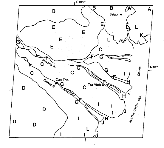
The Mekong delta covers an area of 13 470 km2 in Vietnam (Gagliano and McIntire, 1968). This image of the delta is somewhat obscured by cloud cover that is common in the tropics. The delta is bounded to the northwest by pre-Quaternary surfaces, only a small area of which appears on the image (A). Pleistocene terraces border the river and delta; in the lower delta, these terraces (B) gradually dip below the modern deltaic plain (C). To the southwest of the delta plain lies the Trans Bassac depression (D), a lowlands that parallels the main southern distributary, the Bassac. This region is one of the natural overflow basins of the Mekong system through which large volumes of river flow move westward to the Gulf of Thailand. This relatively featureless flat plain has been constructed by sediment drifting southwest along the coast from the river mouths and by overbank flooding. Much of the area consists primarily of brackish water marshes and small tidal channels bordered by mangrove vegetation. Some of the area has been reclaimed for agricultural purposes, and many of the long straight scars on the image represent irrigation canals.
| Figure D-7.1 | Figure D-7.2 |
|---|---|
 |
 |
The largest basin in the delta is the vast, primarily uncultivated Plain of Reeds (E), which has an area of 4560 km2. Cultivation is restricted mainly to the small channel banks of sluggish streams and along the long manmade canal banks that are used for drainage. The vegetation of this plain consists mainly of numerous species of Juncus, a fresh to brackish water marsh plant.
The major distributaries (F) of the delta plain (Figure D-7.1) are characterized by a braided pattern, with channel division around alluvial or midchannel islands. Migration of channel banks is quite high and often erratic in nature, as shown by ridge and swale topography (Figure D-7.2). Most of the midchannel islands have been diked and are cultivated. Among the most conspicuous landforms in this delta are the broad natural levees (G) that border the active channels and surround the interdistributary basins (called bengs in Vietnam). These levees are relatively high, averaging several meters above the adjacent marshy interdistributary surface. Overbank splays are quite common and tend to form small erosional channels across a natural levee. These overbank channels are generally markedly straight and parallel to one another. The high tide, which constantly causes reversals in flow near the river mouths, results in well-developed bell- shaped river-mouth morphology (H) containing numerous bars and spits that obstruct the river mouth. This type of channel-mouth morphology is quite common on most high-tide-dominated river deltas. Discharge down a particular distributary has varied with time, thus introducing pulses of sedimentation at a specific river mouth.
| Figure D-7.3 |
|---|
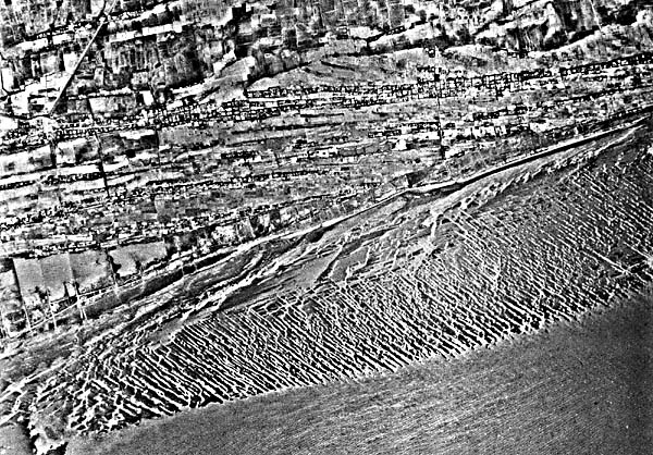 |
As a result of alternating progradation and coastal retreat, the morphology of the lower delta plain exhibits alternating stranded beach ridges (I) and mudflats (Figure D-7.3). This beach-dune ridge plain extends inland to distances up to 60 km. These stranded beaches or cheniers are composed of sand and shell, parallel the coastline, and display elevations up to 5 m above the adjacent swales. The swales are normally occupied by small tidal channels and salt- tolerant vegetation such as mangrove and Nipa palm. Coastal mudflat sediments underlie the salt marshes and swamps. The elevations of these ridges make them ideal sites for habitation and cultivation of oil palms. The delta shoreline is normally fronted by broad tidal mudflats (J) that are exposed at low tide (Figure D-7.3). Large volumes of organic debris that accumulate on these mudflats are extremely rich biologically.
Mangrove vegetation (K) is spread throughout the lower delta plain and on the banks of the numerous small tidal channels. The bulk of the mangrove area, however, is situated in the tidal estuary (L) southeast of Saigon. This basin lies "updrift" of the delta and is deprived of sediment nourishment from the adjacent river mouths. An intricate network of interconnected tidal channels cuts through the mangrove and Nipa palm swamps and marshes. Landsat 1163-02450-7, January 2, 1973.
Continue to Plate D-8| Chapter 5 Table of Contents| Return to Home Page| Complete Table of Contents|