 |
 |
|---|---|
| Plate C-14 | Map |
|
|
|---|---|
| Plate C-14 | Map |
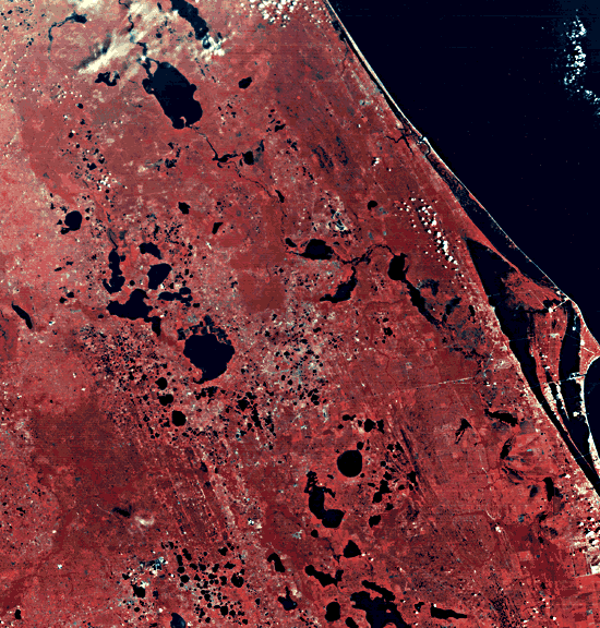
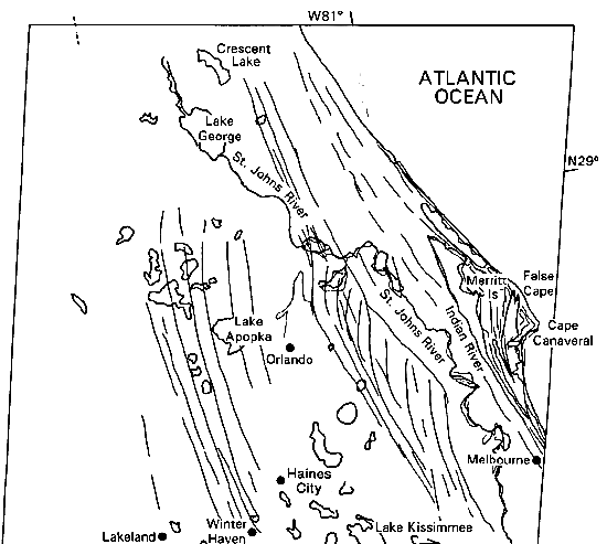
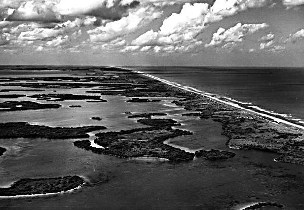
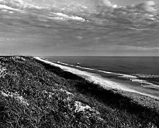
Cape Canaveral is the southernmost of the cuspate forelands on the U.S. Atlantic coast barrier system. It is the site of Cape Kennedy Air Force Station and NASA's Kennedy Space Center (KSC). The cuspate foreland has officially reverted to its traditional name after being called Cape Kennedy for a few years in the 1960s. Numerous rocket launch pads are visible in the false-color Landsat scene as uniformly spaced light patches along the shoreline of the Cape. Views of the coast up and down from the Cape appear in Figure C-14.1 and Figure C-14.2. More details in and around KSC are visible in the Landsat RBV image reproduced in Figure C-14.3.
Cape Canaveral is approximately the southern limit of quartz- rich detrital sand transported southward from rivers that drain the coastal plain, the piedmont, and the Appalachian Mountains of the southeastern states. Most of the detrital sediment of Cape Canaveral is mixed with and bound together by weakly cemented biogenic limestone. Masses of broken mollusk shells cement easily by ground water to become coquina, a shelly conglomerate that may be strong enough to be used as a building material or to protect fossil beach ridges from later erosion. The weakly cemented mixture of detrital quartz and biogenic limestone is so resistant to erosion that several generations of the ancient beach ridges that predate Cape Canaveral can be easily traced in the view.
| Figure C-14.1 | Figure C-14.2 |
|---|---|
 |
 |
The oldest fossil shoreline is a series of detrital sand ridges that trend slightly east of south through western Orlando and Haines City. Rising 50 to 60 m above present sea level, these ridges are deeply weathered and leached of any former carbonate material. They may be as old as Pliocene or Late Miocene age (perhaps 3 to 5 Ma) (MacNeil, 1950). The sandy cover of central Florida frequently collapses into karst sinkholes in the underlying Ocala limestone, with disastrous results (Plate KL-4). The maze of lakes in the central part of the image are karst sinkholes, by the generally high rainfall of the region and the low relief that inhibits ground-water movement.
A second series of fossil barrier ridges can be traced between Orlando and the St. Johns River. These have most recently been referred to as the Effingham Sequence, named for Effingham County in Georgia (Winkler and Howard, 1977). They are generally below 30 m altitude and have been correlated with the Wicomico and Waccamaw formations of Georgia and South Carolina. They are estimated to be of Early Pleistocene age, between 1.0 and 1.7 Ma old. The Effingham beach ridges are distinctive in that they show a series of cuspate forelands of dimension similar to Merritt Island and Cape Canaveral.
Between the St. Johns River and Indian River, and including Merritt Island, is the next younger series of ancient beach ridges. These ridges, named the Chatham Sequence by Winkler and Howard (1977), show a well-developed cuspate foreland in Merritt Island, now truncated by Cape Canaveral except where the modern barrier is deflected seaward by the resistant cemented coquina beach ridges at False Cape. A few radiometric dates on poorly preserved mollusk shells suggest that this sequence, now less than 10 m above sea level, is about 100 000 years old. It was probably built during the last interglacial interval when sea level was a few meters above the present level (Osmond et al., 1970). Although the older higher beach ridges inland require a slight amount of tectonic uplift over the past few million years, the Chatham Sequence could have been built during a higher sea level, rather than having been uplifted in the last 100 000 years. These are probably of the same ages as the ridges that control the Sea Islands of Georgia and South Carolina, and are buried under the modern barriers of Cape Hatteras.
| Figure C-14.3 |
|---|
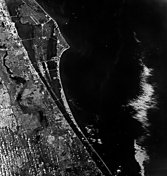 |
Thus, as noted in Plate C-13, the modern barriers on the southeastern U.S. coast are only the latest of a long series of such forms that were built in the Tertiary Period as the coastal plain gradually accumulated sediment and prograded seaward. But during the Pleistocene Epoch, the repeated rise and fall of sea level through a range of 100 m in harmony with each ice age has complicated the longer term progradation. Each ice age exposed most of the shelf, and rivers extended their lower valleys nearly out to the shelf margin (Field and Duane, 1974). As sea level rose, the shoreline again migrated landward. Especially in the last 5000 to 6000 years, the most recent rise of sea level has driven older barrier systems landward across the shelf or overtopped them to form newer barriers near the transgressing shoreline. In many regions, the youngest Holocene barriers have been stabilized by older eroded barrier segments. Like the cuspate forelands of Cape Hatteras and the Sea Isles, the modern Cape Canaveral foreland has probably accreted and migrated southward in the last few thousand years, although massive construction at the Kennedy Space Center has now destroyed many of the prehistoric beach ridges on the Cape. Landsat 1045-15275, September 9, 1972.
Continue to Plate C-15| Chapter 6 Table of Contents.| Return to Home Page| Complete Table of Contents|