 |
Figure 7.1 |
|---|---|
 |
Map 7-1 |
Robert W. Blair, Jr.*
This chapter is concerned with the recognition and origin of karst topography and certain types of lake basins and is not intended to be a comprehensive text-style dissertation on either karst or lakes. For more specific information, see Jennings (1971), Sweeting (1972), or Hutchinson (1957). The category of lakes, although a separate topic from karst, has been included because we believe that it does not warrant a special chapter and because the number of good images displaying karst is limited. The approach is by necessity a regional one, with little discussion related to landforms that are not observable from space.
Introduction
The term "karst" stems from the region Krs in Slovenia, now in northwestern Yugoslavia, which is typified by stony barren rock (Figure 7.l). The Indo- European word "kar" for rock and the Italian word "carso" evolved to the Germanized term"karst," which is now the accepted term for solution-derived landscapes like those just north and east of the Adriatic Sea.Karstification is the geologic process of differential chemical and mechanical erosion by water on soluble bodies of rock, such as limestone, dolomite, gypsum, or salt, at or near the Earth´s surface. Karstification is exhibited best on thick, fractured, and pure limestones in a humid environment in which the subsurface and surface are being modified simultaneously. The resulting karst morphology is usually characterized by dolines (sinkholes), hums (towers), caves, and a complex subsurface drainage system.
Factors in Karst Development
The development of karst terrain depends on the interplay of at least seven important factors in varying degrees. These are: lithology, structure, relief, hydrology, climate, vegetation, and time.
Lithology. Several lithologies are susceptible to karstification, but limestones and dolomites, owing to their solubility and nature of resistance and widespread distribution, are overwhelmingly dominant. According to Pettijohn (1975), 75 percent of the Earth´s surface is covered with sedimentary rocks, and of that, 10 to 20 percent consists of limestones or dolomite. Karst morphology can occur on carbonates with less purity than 80 percent, but generally the purer the limestone, the better the development of karst morphology (Jennings, 1971). For example, the Cretaceous and Early Tertiary Dinaric karst limestones of Yugoslavia are 95 to 100 percent pure (Herak, 1972), and white limestone in Jamaica seldom exhibits less than 98 percent purity. Numerous compositional variations can exist in carbonates, and many of these are discussed in Sweeting (1972) and Jennings (1971).
|
Figure 7.1 |
|---|---|
|
Map 7-1 |
In addition to the composition of limestone, the thickness of individual beds, the nature of interbeds, especially shaly beds, and lateral facies variations affect the style and degree of karstification. In the Dinaric Mountains, the depth of surface karstification is sometimes limited by impermeable beds which have aided the development of broad flat-floored valleys called poljes (Herak, 1972).
Structure. Structure is used here in the structural geologic sense and is concerned with the attitude and deformational effects of bedrock. Limestones and dolomites at or near the surface tend to deform by brittle fracture. This tendency to form complex joint sets is directly responsible for the secondary permeability required for the development of subsurface solution drainage and subsequent three-dimensional cave development. Vertical fractures usually manifest themselves at the surface and focus the solution processes along them. The influence of fracturing is paramount in southeast China, where thousands of square kilometers are affected by several consistent sets of joints (see Plate KL-1, karst of south China). Folding, in addition, may have the effect of isolating watersheds and directing ground-water flow. This has occurred in the Dinaric karst of Yugoslavia.
Large-scale structures or tectonics not only have led to the development of specific landforms like poljes but have also influenced the rates and degree of karstification. Most poljes, for example, are associated with boundary faults (Roglic, 1972). Uplift and deformation of a carbonate plateau accelerates the dissolution of the limestone because: (1) fracture density increases, (2) any elevation rise is usually accompanied by an increase in precipitation, and (3) increased relief increases piezometric surface gradients. These conditions can: (1) lead to solution-enlarged conduits along fracture planes, (2) impart to the limestone a high hydraulic conductivity, and (3) cause rapid fluctuations in the water table with accompanying accelerated solution (Fetter, 1980)
.Relief. Topographic relief is the elevation difference between the highest and lowest points on the surface for a given area. The Julian Alps in the inner region of Yugoslavia have a topographic relief near 2000 m. This mountainous area is associated with an abundance of potholes and few caves. Both characteristics are thought to be a consequence of this high relief (Herak, 1972). Related to relief is the depth of the vadose zone, which is the vertical distance between the surface and the water table. In Florida, the vadose depth is small, as is the topographic relief. However, throughout low sea level stands during the Pleistocene, the increased depth of the vadose zone probably led to the development of a more extensive and efficient subsurface drainage system with an increase in dissolution along fractures and fissures. With the absence of the buoyancy effect of a high water table surface, the formation of collapse dolines may have been accelerated (see Plate KL-4, Florida karst). Even today the effects of water table drawdown due to excessive pumping have rendered some urban areas susceptible to the sudden and unexpected collapse of buried solution cavities. Such a collapse occurred in Winter Park, Florida, in May 1981.
Hydrogeology. Hydrogeology is concerned with the interrelation ships of geologic materials and processes with water (Fetter, 1980). The karstification process involves not only the solution of limestone but also the sometimes overlooked mechanical erosion of limestone. Because the solution chemistry of carbonates is well known (Jennings, 1971; Sweeting, 1972; Bogli, 1980), only a brief summary will be presented here.The dissolution of limestone involves three principal components: carbon dioxide, water, and calcium carbonate. Initially, atmospheric carbon dioxide diffuses into the moisture within the air or soil and simultaneously becomes hydrated to form carbonic acid:
In the presence of limestone, carbonic acid dissolves the calcite. The reaction is often presented as:
| CaCO3 + CO2 + H2O | <-> | Ca++ + 2HCO3- |
|---|---|---|
| limestone | dissolved limestone |
The only water that is capable of dissolving limestone is aggressive water, which is water undersaturated with respect to dissolved carbonate. The time required for aggressive water in karst regions to be neutralized or to reach saturation equilibrium varies considerably, depending on a number of factors such as temperature, turbulence, variations in the partial pressure of carbon dioxide, dilution, presence of other acids, and surface area of limestone. To achieve equilibrium may require several days; however, laboratory studies suggest that most of the limestone dissolution resulting from an influx of fresh aggressive water may occur within minutes to a few hours (Sweeting, 1972; Jakucs, 1977; Ritter, 1978). Additional acids, such as organic acids from soils and most recently sulfuric and nitric acids from acid rain, will contribute to the dissolution of carbonate rocks.
Once saturation equilibrium is achieved, any change to warmer water temperatures or decreases in the partial pressure of carbon dioxide can drive equation 7-2 to the left, resulting in the deposition of calcium carbonate (see Figure 7.2).
Erosion rates have been calculated for many karst regions around the world and vary widely even within the same climatic zone (Smith and Atkinson, 1976).
 |
Figure 7.2. Saturation equilibrium curves for solution of calcium carbonate at selected temperatures as a function of carbon dioxide equilibrium in solution (modified after Jennings, 1971, p. 26). |
|---|
Table 7-1 lists some of the calculated erosion rates for karst regions discussed in this chapter. Although these erosion rates are useful for comparative purposes, they are not indicative of the duration intensity of the erosion process. The dissolution of the limestone does not take place at a constant rate, but fluctuates with storm events that flood the karst surface and subsurface with undersaturated water. In other words, the actual dissolution occurs episodically with maximum peaks corresponding to surges in the karst water flow. In Jamaica, intense storm events result in subsurface flooding, and because the existing conduit system is not of sufficient size to handle excessive infiltration rates, backfilling of caves and solution channels occurs with fresh undersaturated water (Versey, 1972). These flood events can be of the single-storm variety or may be seasonal, as with the winter flooding of poljes in Yugoslavia.
Because of the unusually high permeabilities and the periodic flooding associated with most karst regions, the water table correspondingly exhibits drastic fluctuations. This has been observed by many spelunkers. The water table in karst rock is frequently difficult to define, especially in free- flow carbonate aquifers that display a complex multitude of enlarged open conduits. The water table can occur at considerable depths below the land surface, especially in mountainous regions like the Dinaric Mountains, Yugoslavia. Water can also be perched under solution depressions above the water table or it may be discontinuous if the permeability is principally fracture-controlled (Fetter, 1980). Zones with few or no fractures yield little or no water, in contrast to dense fracture zones that can potentially supply abundant water.
| Location | Erosion Rate (m3/km3/yr) |
Climate |
|---|---|---|
| Florida USA* | 35,5,8 | Tropical |
| Jamaica* | 69,39,86,96 | Do |
| Yucatan, Mexico* | 30,16 | Do |
| Guangxi, S.China+ | 120-300 (surface) | Do |
| Dinaric karst, Yugoslavia* | 43,63,55,67 | Temperate |
| S. Nullarbor Plain, Australia± | 5 (surface) | Semiarid | ,
Climate. The best-developed karst regions of the world are found in tropical (e.g., Jamaica) and temperate (e.g., Yugoslavia) environments. Considerable discussion has evolved as to whether tropical or temperate environments are more conducive to karstification (Smith and Atkinson, 1976). Lehmann (1970), a strong advocate of climatic geomorphology, asserts that solutional erosion rates are more intense in the tropics because of greater rainfall and carbon dioxide production in soils at higher temperatures. In contrast, Corbel (1959) contends that the intensity is greater in cold humid climates where larger quantities of carbon dioxide can be absorbed by water. The higher the carbon dioxide absorption in water, the stronger is the resultant carbonic acid. However, because Corbel overlooked the rates of reaction, which slow down at lower temperatures, the levels of CO2content may be irrelevant (Embleton, 1985, personal communication).
The absorption of carbon dioxide is temperature-dependent so that cooler water for a given volume can absorb larger quantities of carbon dioxide. If the water temperature rises from 0 to 35°C, the carbon dioxide saturation level will decrease between one-third to two-thirds (Jennings, 1971). Therefore, waters in cold climates can hold greater quantities of carbon dioxide in the ionic state, thus being more effective in dissolving limestone. However, more important than temperature is the partial pressure of carbon dioxide, which at sea level is relatively constant at 0.035 percent. The partial pressure of carbon dioxide in soil air can exceed that of the atmosphere from ten to several hundred times (Bogli, 1980). As a consequence, the presence and nature of soil cover can be far more important in karstification intensity than atmospheric air.
A study by Smith and Atkinson (1976) of comparative karst data from around the world indicates that mean annual runoff, rather than precipitation, is the principal parameter directly related to erosion rate. Temperature is believed to be important only with regard to its influence on supporting a continuous cover of soil and vegetation.
Vegetation. Arid karst regions, such as the Nullarbor Plain in Australia, are associated with sparse vegetation, thin soils, and therefore, a slowed rate of surface karstification. In contrast, if the existing soil and climate can support a dense vegetation cover, an intensified surface and subsurface karstification occurs, as observed in Jamaica and south China. Biogenic carbon dioxide, introduced to the soil by plant root systems and bacterial decay, is regarded as the most important control of solution erosion of limestones (Jennings, 1971).
Generally, where vegetation is most lush, the highest concentration of moisture, the highest biogenic activity, and the highest production rates of carbon dioxide occur. Under these conditions and free water circulation, the highest solution erosion rates can be achieved. Such conditions are found in both Jamaica and south China (Table 7-1). In Jamaica, the forest canopy has been cited as one of the prime factors responsible for the overdeepening of cockpits (Versey, 1972).
Time. The early karst studies of Cvijic and Grund at the turn of the 20th century were strongly influenced by the cyclic evolutionary teachings of Davis and Penck (Roglic, 1972). Thus, karst topography has been thought to evolve through stages of development beginning with fluvial action and the initial formation of dolines. As the surface drainage is slowly captured by swallow holes and the developing subsurface drainage, dolines coalesce to form uvalas, which, in turn, expand to poljes. This sequence is now considered to be antiquated, and according to Roglic, poljes are structurally controlled and are not related to uvalas.
It is questionable whether any two karst regions anywhere in the world have evolved sequentially in the same manner or even display identical morphological forms. Each karst region evolves within its unique combination of dynamic and static factors. However, this does not preclude the comparison of areas of similar morphology in an attempt to evaluate common factors.
From the examples of Landsat imagery in this chapter, it becomes apparent that each region has developed its own morphologic signature. To understand the evolution of a given karst terrain, it is necessary to comprehend the roles of length of time, style, and intensity of the energy flow through the hydrologic system. Those karst regions with the largest potential energy, related to the thickness of the vadose zone, and kinetic energy, or flooding, will also exhibit a higher energy morphology more rapidly and more fully than regions of lower total energy. High-energy morphology can be manifested in the form of larger caves, increased relief, density, and magnitude of dolines, hums, flood deposits, and a more extensive underground solution network.
Within the realm of geomorphology, each geologic process leaves its own imprint on the Earth´s landscape, and each process will develop its own characteristic assemblage of landforms (Thornbury, 1969). For karst landscapes, this imprint is expressed as solution morphology on the regional scale. Because of the relatively large ground resolution distance of 79 m, many karst landforms cannot be discerned from Landsat MSS images; only the larger solution and fracture-controlled dolines and uvalas can be recognized. Thus, the advantage of the space perspective is not the identification or the recognition of individual landforms, but the collective pattern and texture they impart to a region of hundreds or thousands of square kilometers. This can occur only where given geologic processes and materials, such as carbonates, dominate a large region for a sufficient length of time.
The Landsat imagery discussed in this chapter has been chosen from the known karst regions of the world. Some well-researched regions are not included either because good imagery has not been available (e.g., New Guinea) or because man´s overprint (e.g., Indiana, U.S.A.) is so dominant as to obscure natural topographic patterns.
A cursory examination of all the karst images reveals a number of features specifically associated with the solution process:
Most important is the absence of a well-developed integrated surface drainage. Indeed, for the Nullarbor Plain, Australia, and Yucatan, Mexico, it is difficult to identify any recognizable drainage. Major rivers can be seen to incise the south China carbonate plateaus, but there is a distinct lack of well-developed tributaries draining into the river channels.
Most karst areas exhibit a relatively homogeneous pock-marked or dimpled texture. In south China, this pattern is overprinted with solution- incised joint sets. In Florida, the pattern is expressed as numerous large water-filled collapsed basins.
Joint sets are not recognized in all karst areas at Landsat scale. This does not preclude the presence of joints, but merely points out that they may be obscured because: (1) joints are too closely spaced, (2) solution relief of joints is slight, (3) dense vegetation cover is present, or (4) joints may indeed be absent or sparse.
What accounts for the large differences observed in karst regions is not variation in the karst process, but variation in lithology, structure, and the overprint of other processes like fluvial, tectonic, eolian, and glacial, and variations in the energy flow through the karst system through time.
Introduction
According to the American Heritage Dictionary (Dell Publishing Co., Inc., 1983), a lake is defined as "a large inland body of water." The interpretation of the word "large" is conjectural. For our purposes, a lake must be large enough to be recognizable on Landsat imagery, which is limited by the ground resolution distance of 79 m and 30 m for the MSS and TM sensors, respectively. It is because of the presence of water that we easily recognize and focus our attention on these geomorphic forms. To develop a lake requires two things: (1) geomorphic process(es) to form a depression, and (2) the proper hydrologic and climatic conditions to maintain a confined body of water on the Earth´s surface.
Classification
Virtually every geomorphic process is capable of producing a depression either singly or in combination. A classification of lakes is, in essence, a classification of various geomorphic processes. Davis (1882) proposes a classification of lakes based on constructive, destructive, and obstructive processes, and Hutchinson (1957) presents a detailed classification system based on various geologic processes.
The following is a modified Hutchinson classification:
Origin
One objective of this section is to study various lake basins observable from space, and from their geometry, geologic, and geomorphic associations, point out characteristics that could reveal information about their origin. The study of the origin of lakes can be segmented into two lines of inquiry: (1) causes of topographic depression, and (2) explanation for the presence of water. The first line of inquiry listed is more amenable to study through space imagery than the latter. Note that many depressions exist that do not contain water, and as a consequence, their presence may be overlooked.
Physical criteria useful in the analysis of lakes from space are shape, size, density, and nature of the surrounding terrain.
Shape. Lake shape in many instances can narrow the choices of geologic process responsible for an inland depression. Circular topographic basins, for instance, can be produced by collapse (dolines, calderas), by explosions (volcanic craters, meteoric impact), or from wind (deflation hollows). Circular lakes, associated with these processes and visible on Landsat imagery, include the doline lakes in north central Florida, the caldera lakes from Nicaragua, a volcanic crater lake at Crater Butte, California, an impact lake in Chubb Lake, Quebec, and the deflation hollow lakes found on the Llano Estacado, Texas.
The best-developed elliptical basin lakes are the Carolina Bays in North and South Carolina and the oriented lakes of Alaska. Surface wave erosion, aided by wind at right angles to the long axis, is believed to be the major controlling factor in their elongation (Kaczorowski, 1976).
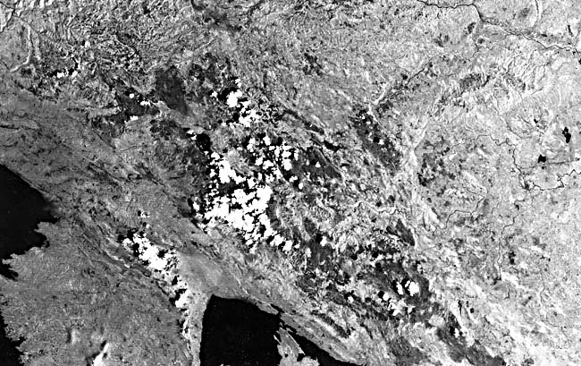
| Figure 7.3a.. This Landsat scene (1057-16305-7), September 18, 1972) shows numerous linear lakes produced by glacial scouring along fracture zones in Canadian Shield crystalline rocks in the Lac La Ronge area, central Saskatchewan. | 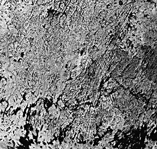 |
|---|
Dammed drainage basins produce dendritic lake patterns. The dams may be natural or, more frequently, manmade. In 1959, Earthquake Lake formed as a result of the Hebgen Lake earthquake, which jolted into motion 20 million m3 of rock and debris that subsequently dammed the Madison River in southwestern Montana (Costa and Baker, 1981). Lake Kioga in East Africa formed after epeirogenic tilting reversed the drainage in a large watershed and caused the eventual flooding of the tributary valleys. Manmade reservoirs are especially abundant in the southeastern United States, but they may be found in virtually every country of the world.
Linear lakes, including many on the Canadian Shield (Figure 7.3a and Figure 7.3b), are commonly imposed on fracture- or fault-controlled zones of weakness that localize streamflow or are gouged out by glacial scour. Triangular lake basins are found in the stabilized dune fields of Senegal. Rectangular lake basins have been noted in northwestern Yukon Territory, Canada; their origin is unknown, but structure and permafrost probably play a role in their development. Lunate or oxbow lake basins are common along meandering river channels such as the Mississippi River. These lakes are formed from abandoned meanders, usually during flood cycles. Irregular or amoebic-shaped lake basins are frequently associated with glacial till and are caused by the differential melting of buried ice or by water filling the low points on a hummocky moraine. These lakes are common in north-central North America and in Scandinavia. Some lake basins are so irregular and abundant that they resemble ink-splatter patterns and can be found in Canada, in Scandinavia, and in Siberia where large areas of bedrock have been laid bare by continental ice sheets. Frozen tundra, bedrock structure, and differential erosion have contributed to their highly irregular pattern.
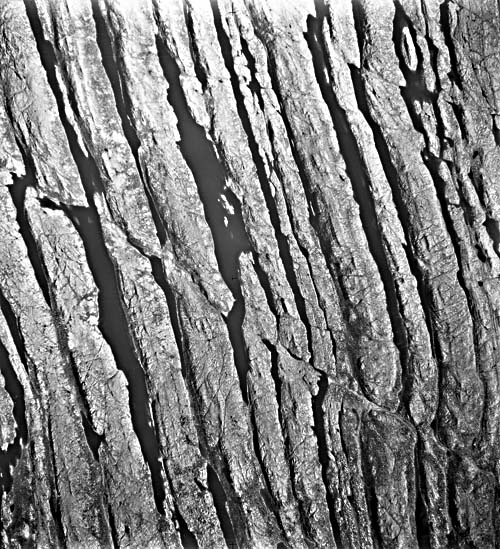 |
Figure 7.3b. Aerial view of glacial scour lakes along fractures in the eastern Canadian Shield (Canadian Department of Energy, Mines, and Resources, A11607-84). |
|---|
Size. Of the world´s ten largest lake basins based on water surface area, six have a tectonic origin and four are glacially derived (Smith, 1968). At various times during the Pleistocene, glacial lakes have grown in size and probably out-numbered large tectonic lakes. Lake Bonneville in the Basin and Range of Utah and Minchin Lake in Bolivia are examples. These pluvial lakes were large because the cooler climate during glacial periods favored the storage of surface water. The largest lake basins have developed in response to a regional stimulus in contrast to small isolated lakes that may result from local influences.
Density. The density of lake basins per unit area can again indicate the regionality of a geomorphic process. The tens of thousands of lakes in central Canada and north-central United States reveal the ubiquity of the glacial process. The Carolina Bays of the southeastern United States and the oriented lakes of Alaska exhibit the regional influence of wind and, in the case of Alaska, further influence by permafrost. With isolated small lakes, such as Earthquake Lake, Montana, local geomorphic processes must be examined to determine the lake´s origin.
Associated Terrain. Clues to a lake´s origin, as viewed on Landsat imagery, are frequently revealed by the regional overprint of a particular geomorphic process. The presence of dune fields in Senegal and glacial moraines in Quebec, Canada, and the abundance of volcanoes around Lake Nicaragua, all suggest to the observer a cause-and-effect relationship. Many rift lakes display straight-lined shores with angular bends mirrored on the opposite shore. Inland faults may parallel the lake edge and indicate a tectonic origin. Lake Tanganyika is an example. Lakes associated with the dimpled surface texture indicative of karst topography may well be water-filled dolines. The Dinaric Mountains of Yugoslavia have a few lakes of this variety. However, the most well-developed karst regions of the world as in Yugoslavia, south China, and Jamaica do not display abundant lakes. This is due, in part, to the efficient infiltration of precipitation and a subterranean piezometric surface.
Time
Within our timeframe, lakes may develop catastrophically from volcanic eruptions, landslides, and earthquake activity, or they may form from slower acting processes like wind, glacial, and epeirogenic activity. However, it is important to emphasize that, geologically, lakes are temporary and form rapidly and decay quickly (Smith, 1968). Because most of the Earth´s land surface is dominated by fluvial erosion, lakes that do occur are threatened with either capture and draining by expanding tributaries or infilling of sediment until the lake becomes extinct. The mere presence of a lake, then, demonstrates the dynamic restlessness of the Earth´s surface.
Continue to Plate KL-1| Chapter 7 table of Contents| Return to Geomorphology Home Page| Complete Table of Contents|