 |
 |
|---|---|
| Plate KL-1 | Map |
|
|
|---|---|
| Plate KL-1 | Map |
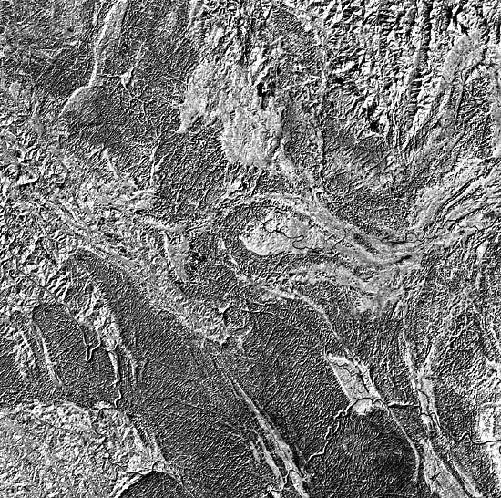
The portion of south China displayed in this Landsat image encompasses part of the most spectacular karst topography found anywhere on Earth. The carbonate rocks show up as the dark-toned areas on the image. Reference to karst in China is found frequently in early Chinese literature and is depicted in their art. This is not surprising because over 1.2 million km2 of China is exposed karst. This solution topography is best developed in south China where carbonate rocks spanning from Late Precambrian to Triassic attain thicknesses of 3000 to 10 000 m (Daoxian,1981).
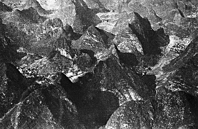
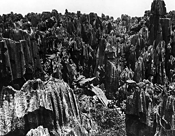
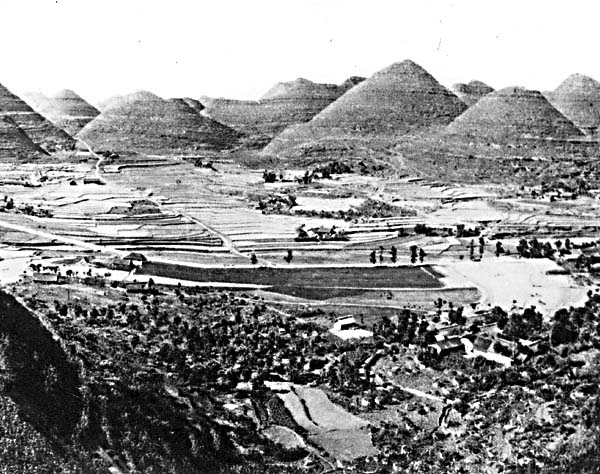
Carbonate rocks of the central Guangxi Province (this Plate) are characterized by a continuous age sequence from Devonian through Triassic with a cumulative thickness of 3000 m. Most of the exposed karst in the image displays the peak-cluster or cockpit-like morphology (Figure KL-1.1) that the Chinese call "Fengcong" (Daoxian,1981). These grouped peaks and depressions share a common carbonate basement (see region A on index map) in which the solution is strongly controlled by jointing (Figure KL-1.2). Another common karst form is the Fenglin, or peak forest, which consists of multiple carbonate pillars sometimes separated by flat plains that can be of corrosional or aggradational origin. These are common around Guilin (Figure KL-1.3), a tourist center approximately 130 km east of the image area. A region of similar terrain is located near the center right edge of the image (B on index map). Daoxian (1981) notes that, although much Fenglin topography is often associated with a later stage of development of the Fengcong topography, no such relationship has been documented. Indeed, Chinese studies (Daoxian, 198 1) suggest that Fengcong may be the same age as Fenglin and that Fenglin does not necessarily pass through a Fengcong stage in its development. Still another variant are karst towers expressed as cone-shaped hills (Figure KL-1.4), equivalent to hums in Yugoslavian terminology (Plate KL-4).
| Figure KL-1.1 | Figure KL-1.2 |
|---|---|
 |
 |
The hydrology of the Fengcong differs from the Fenglin in that vertical infiltrating water through a thick vadose zone dominates in the former whereas horizontal ground-water flow influences the latter (Daoxian, 1981).
A fundamental characteristic of the exposed or bare karst is its lack of a surface drainage network. Within this image of the central Guangxi Province, there are several main rivers, but there is a lack of tributary development. In this region, over 1000 underground streams with a cumulative discharge in excess of 700 m3/s have been explored and thousands of caves have been detected or mapped (Daoxian, 1981, 1983).
The labyrinth of underground drainage channels drains most surface runoff through swallow holes and solution fissures. The surface and subsurface drainage have evolved together and are integrated. For instance, the Sanshi Polje (see index map), which is surrounded by cockpit-like karst, is drained by the Banmen underground stream through a swallow hole to the east. The Banmen subsurface stream flows for 10 km eastward into the Hongshui River. The efficiency of these underground drainage systems presents its own special set of problems related to flooding and droughts. Sixty-six to eighty percent of the south China rainfall is concentrated during the wet summer months of May through August. Its rapid loss to the subsurface drainage system often results in drought conditions, even though the annual precipitation is 1000 to 2000 mm (Daoxian, 1983).
| Figure KL-1.3 | Figure KL-1.4 |
|---|---|
 |
 |
Why is the south China karst so much more spectacular than other karst areas of the world? The answer is not simple, but several distinct features set China karst apart. First is the huge thickness (exceeding 3000 m) of virtually uninterrupted sequences of massive crystalline limestone and dolomites over an area between 1 and 2 million km3. Secondly, this area has undergone a slow epeirogenic uplift during the Cenozoic Era, exposing broad plateaus of gently dipping to horizontal carbonate strata (Sweeting, 1978).
Although pre-Cretaceous paleokarst exists in places, the dominant solution topography seen today developed during the Cenozoic. Recently, solution rates in the Guangxi Province have been measured at 0.12 to 0.3 mm/yr (Daoxian, 1981).
The concordance of summits forming the regional plateau-like surfaces, identified as the dark-toned areas on the image, are believed to represent an uplifted Late Cretaceous peneplain (Sweeting, 1978). The presence of regional jointing is seen as a crisscross pattern on the image and may represent conjugate shear fractures related to folding. Localized deformation has complicated the evolution and has increased the diversity of the karst topography. For example, the Sanshi Polje represents a faulted syncline and the karst topography around Guilin developed upon a downfolded sequence of Devonian limestones. Landsat 1524-02432-7, December 29, 1973.
Continue to Plate KL-2| Chapter 7 Table of Contents.| Return to Home Page| Complete Table of Contents