 |
 |
|---|---|
| Plate KL-4 | Map |
|
|
|---|---|
| Plate KL-4 | Map |
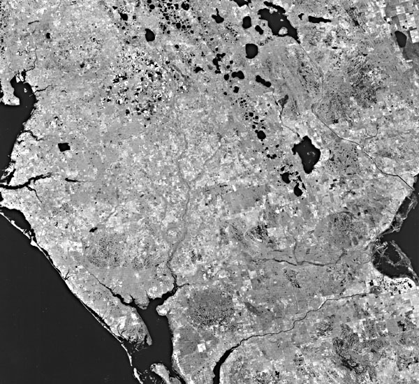
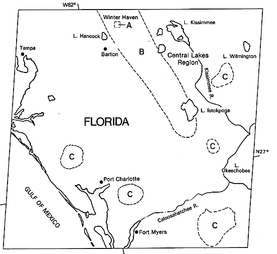
West-central Florida, shown in the Landsat scene, is part of the Central or Mid-Peninsular Zone (geomorphic division of White, 1970). Florida karst is characterized by the abundance of depressions, many filled with water, and a lack of well-developed surface drainage pattern (Figure KL-4.1, A on index map). Florida is a carbonate plateau with limestones in the region comprising one of the best aquifer systems in the world. Tertiary limestones underlie all of Florida and regionally dip gently toward the south and west. The oldest rocks exposed are Middle Eocene (Avon Park Formation). The Tertiary limestones are some 300 m in thickness with numerous unconformities and facies relationships indicative of frequent marine regressions (Randazzo and Saroop, 1976). Significant diagenetic episodes involving dissolution and dolomitization (Randazzo and Hickey, 1978) have influenced karst development. Miocene and younger clastic sediments blanket the limestones in most areas of Florida.
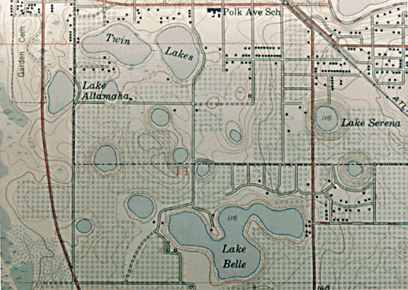
The topography of Florida included within the Landsat image is flat near the coast and becomes gently rolling towards the center. There is a lack of well-defined drainages and an abundance of rounded lake depressions, most of which contain water (Figure KL-4.1). These two characteristics are associated with an integrated subterranean drainage system, high water table, and collapsed depressions. Virtually all depressions seen on the Landsat image are dolines or sinkholes developed on the underlying limestones. Most dolines are shallow depressions, but some exhibit steep sides and contain lakes with depths greater than 25 m (Figure KL-4.2) (Sweeting, 1972). The greatest concentration of large lakes falls along the axis of the Central Lakes region (B on index map) and defines the region most influenced by the Ocala limestone. The Central Lakes region receives in excess of 100 cm/yr of precipitation and is the primary recharge area for the Floridian aquifer.
| Figure KL-4.1 | Figure KL-4.2 |
|---|---|
 |
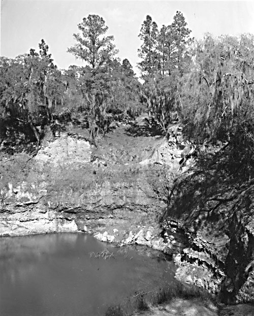 |
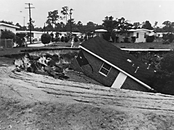
According to Windham and Campbell (1981) and Foose (1981), the subsidence and resultant sinkholes in Florida may occur when several conditions are met. These include a well-developed joint-controlled subsurface drainage network in limestone, a thin to moderate thickness of unconsolidated overburden, and a potentiometric surface below the unconfined water table. The sequence of events that they envision begins with a lowering of the water table either from a drought or from excessive withdrawal of ground water from pumping. As the unconsolidated sediments and weathered debris that overlie the Tertiary limestones dry out, shrinkage cracks and cavities develop. Any subsequent vertical or horizontal percolation of water can enlarge and flush out these cavities through a process known as piping. Some of the unconsolidated sediment may drop directly into pre existing dissolution cavities in the limestone and be carried away by the subsurface drainage system. When the overburden dries, it develops an internal strength capable of supporting itself, even over fairly large cavities. However, when the materials become rewetted from a rainy season or an unusually wet storm, the water weakens the material and gravity stoping can enlarge the cavity until the roof fails. The result is a conical sinkhole, the size of which is largely dependent on the thickness of overburden. The thicker the overburden is, the larger the sinkhole. Most of these depressions develop rapidly and unexpectedly as in Winter Park and Bartow, Florida ( Figure KL-4.3 and index map).
| Figure KL-4.3 |
|---|
 |
Many of the sinkholes and cavernous networks in central Florida probably formed during low sea level stands during the Pleistocene. As the water table dropped in response to a lower sea level, unsupported roofs may have collapsed. Upon the return of high sea level and associated high water tables, further collapse may have ensued. Water now fills many of these sinks.
Several regions of Florida support a prolific number of small sinks (areas C on index map) and support as many as seven or more water- filled depressions per square kilometer. These subcircular regions appear to represent large but very shallow topographic basins with a relief of a meter or less. A shallow-surface water table in these regions is indicated not only from the presence of lakes but also from the darker tones associated with more lush and dense vegetation. Because of a dense lake concentration and small size, factors such as "perched" aquifers and distribution of clay lenses within the overburden are probably involved in their development (A. F. Randazzo, written communication, 1984). Landsat 30244-15181-7, November 4, 1978.
Continue to Plate KL-5| Chapter 7 Table of Contents.| Return to Home Page| Complete Table of Contents