 |
 |
|---|---|
| Plate G-11 | Map |
|
|
|---|---|
| Plate G-11 | Map |
A tidal or tidewater glacier is defined as "a glacier that terminates in the sea, where it usually ends in an ice cliff from which icebergs are discharged" (Bates and Jackson, 1980). Tidal glaciers are some of the best-known glaciers in the world because of the relative ease of accessibility to their termini by the public via ship (e.g., Glacier Bay National Monument, Alaska) and because of their awesome beauty-great bluish white cliffs of ice that periodically span off (calve) into the sea or fjord. Tidal glaciers were much more widespread during the Pleistocene, when many thousands of kilometers of the Antarctic ice sheet and the North American and Eurasian ice sheets terminated as tidal outlet glaciers or ice shelves in the ocean. Today, tidal glaciers are most common in Antarctica (Figure G-11.1; a Landsat view of Pine Island Glacier) (including the Sub-Antarctic islands), Greenland (see Figure G-1.3), Svalbard, Norway (Figure G-10.3), the Arctic islands of the Soviet Union, other Arctic islands, Arctic Canada, the Patagonian and Tierra del Fuego regions (see Plate G-4) of southern South America, and southern and southeastern Alaska.
Southeastern Alaska once had many tidal glaciers, but during the latter part of the Holocene, nearly all of these glaciers retreated well into the heads of their fjords, often in a catastrophic manner. The rapid disintegration of tidal glaciers has been particularly pronounced in the Glacier Bay National Monument area of southeastern Alaska, where a rapid retreat of most glacier termini has been discontinuously observed since the late 18th century. Field (1979) noted that the tidal glacier which had its terminus at the head of Glacier Bay has retreated more than 130 km since 1794. Muir Glacier, which once fully occupied an arm of Glacier Bay called Muir Inlet, retreated 36 km between 1892 and 1976 (Field, 1979).
| Figure G-11.1 | Figure G-11.2 |
|---|---|
 |
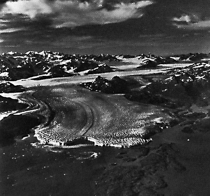 |
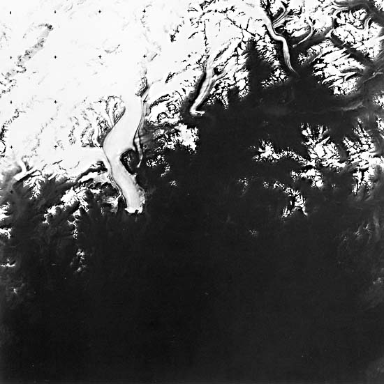
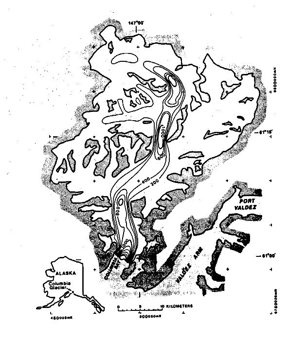
Farther up the coast from Glacier Bay National Monument is Prince William Sound, a bay off the northern part of the Gulf of Alaska, into which flows one of the last of the great tidal glaciers of Alaska, the Columbia Glacier (Field, 1975). Plate G-11 is a Landsat-3 RBV image of the tidal Columbia Glacier, Prince William Sound, Alaska. The index map shows the location of the glacier and different velocities in m/annum (contour interval of 200 m/annum) measured along its length from its terminus to about 50 km up-glacier (Meier, 1983). The terminus of the glacier has retreated back from its terminal moraine at the head of the fjord and has begun a catastrophic retreat. Note the embayment that has formed in the central part of the terminus. Figure G-11.2 is an oblique aerial photo of the terminus of the Columbia Glacier, Prince Williams Sound, Alaska, in July 1976, showing its calving terminus, prominent medial moraines, and crevasse patterns. Figure G-11.3 is an annotated vertical aerial photograph, acquired on December 14, 1984, of Columbia Bay, Prince William Sound, showing successive recessional positions of the terminus of Columbia Glacier during the period August 26, 1978 - December 14, 1984.
Meier (1983) reports that "Columbia Glacier, near Valdez, Alaska, is a fast-flowing glacier of 1,100 km2 area that terminates in an iceberg-calving terminus. Ice velocity at the terminus varies seasonally from 4 to 8 m/day, and it currently discharges about 2 km3/annum of icebergs. A fast- moving "ice stream" [Plate G-3] dominates the flow."
| Figure G-11.3 |
|---|
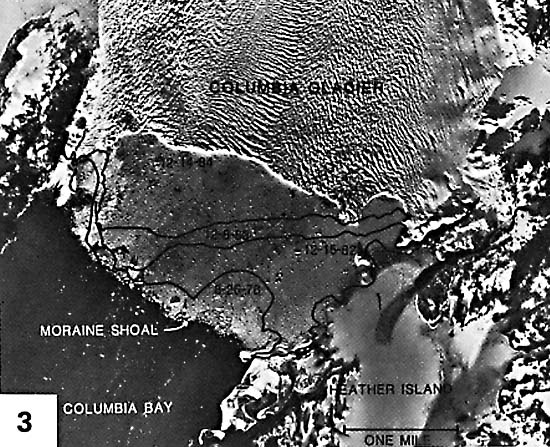 |
The slow retreat of a tidal glacier may suddenly accelerate if it retreats from an end moraine in shallow water to deeper water, resulting in the rapid disintegration of the lower reach of the glacier. Such a situation is occurring at Columbia Glacier, Alaska, where the rapid breakup of its terminus will probably discharge a large volume of small icebergs into Prince William Sound (Meier et al., 1980). If current, wind, and tidal conditions permit, many of these icebergs will drift into the main shipping channel from Valdez, the southern terminus of the trans-Alaska oil pipeline, and perhaps pose a hazard to the giant oil tankers that frequently transit Prince William Sound (Post, 1977).
The Columbia Glacier has been the subject of an intensive scientific study by the U.S. Geological Survey that began in 1974 (Post, 1975). During the course of the study, various types of remotely sensed data have been used, including periodic low-altitude oblique aerial photographs, high- and low-altitude vertical aerial photographs, water-depth determination with hydrographic soundings, Mini-Sparker and Lister Boomer surveys to determine submarine morphology of the terminal-moraine shoal, and airborne and surface radio-echosounding of glacier thickness (Meier et al., 1978). Iceberg plumes have also been mapped from specially enhanced Landsat images (Williams, 1983d).
Figure G-11.1 is a Landsat image of the Pine Island Glacier, an important tidal glacier in West Antarctica that discharges into Pine Island Bay. Williams et al. (1982), working from two Landsat images acquired 750 days apart, calculated an average speed of flow of the terminus of the Pine Island Glacier at 6 m per day. Therefore, this Antarctic tidal glacier flows at about the same speed as the intensively studied Columbia Glacier, an Alaskan tidal glacier. Landsat 30174-20290-D, August 26, 1978.
Continue to Plate G-12| Chapter 9 Table of Contents.| Return to Home Page| Complete Table of Contents|