 |
 |
|---|---|
| Plate G-2 | Map |
|
|
|---|---|
| Plate G-2 | Map |
An ice shelf is defined as "a sheet of very thick ice, with a level or gently undulating surface, which is attached to the land along one side but most of which is afloat and bounded on the seaward side by a steep cliff (ice front) rising 2 to 50 m or more above sea level. Ice shelves have been formed along polar coasts (e.g., those of Antarctica, the Canadian Arctic islands, and Greenland), and they are generally of great breadth, some of them extending several hundreds of kilometers seaward from the coastline. They are nourished by annual snow accumulation and by seaward extension of land glaciers; limited areas may be aground" (Bates and Jackson, 1980).
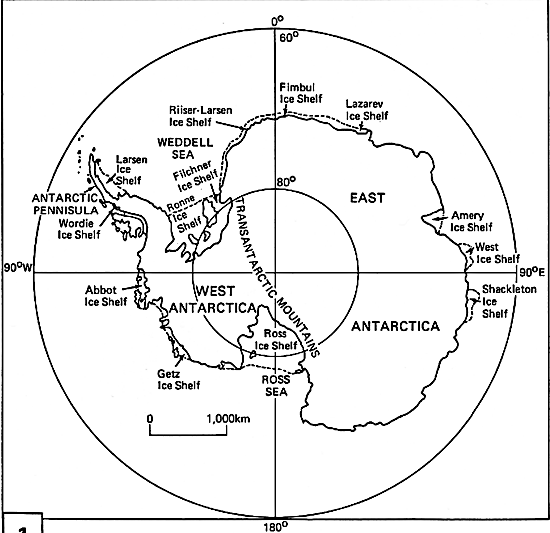
Antarctic ice shelves front on 44 percent of the 31 876-km long coastline of Antarctica (Drewry et al., 1982). Figure G-2.1 shows the location of some of the ice shelves that fringe the periphery or fill coastal embayments in Antarctica, such as the Ross Ice Shelf.
| G-2.1 | Figure G-2.2 |
|---|---|
 |
 |
Although ice shelves are most typical of various embayments around the coast of Antarctica, during the Pleistocene they were associated with the great ice sheets that formed over North America, Greenland, and the northern part of Eurasia, especially where edges of these ice sheets coalesced over large embayments. Denton and Hughes (1981b) suggest that ice shelves formed over parts of the Greenland, Norwegian, and Labrador Seas and even extended into the North Atlantic Ocean. Antarctica has several large ice shelves, such as the Ross (Plate G-1 and Figure G-1.1;this Plate and Figure G-2.2), Amery, Filchner, Ronne, and Larsen Ice Shelves, and several smaller ones, such as the Lazarev and Wordie Ice Shelves. According to Drewry (1983) the ice shelves of Antarctica cover 1 541 710 km2, have a mean thickness of 475 m, and have a volume of 731 900 km3. The ice shelves represent 11.1 percent of the total area but only 0.02 percent of the volume of ice in Antarctica.
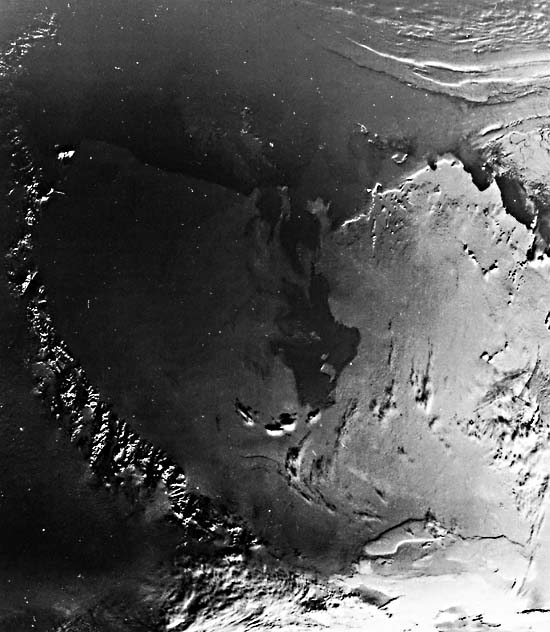
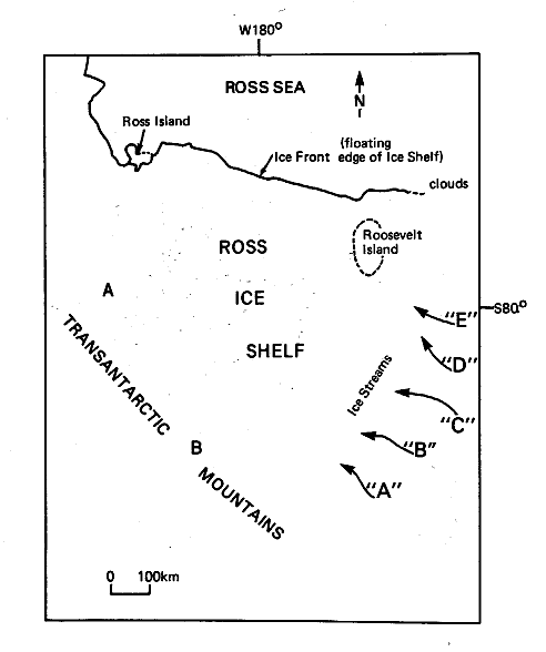
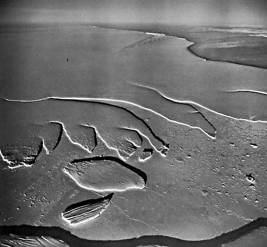
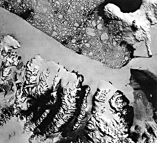
Plate G-2 is a NOAA-6 AVHRR image centered on the Ross Ice Shelf, Antarctica. This image overlaps another NOAA-6 AVHRR image of the area (Plate G-l). The index map shows the principal glaciological and geographic features of the area encompassed by the image. The Ross Ice Shelf is bounded on the west and south by the Transantarctic Mountains through which enormous outlet glaciers, such as the Byrd (A) and Beardmore (B) Glaciers, feed the Ross Ice Shelf as they drain part of the East Antarctic ice sheet. On the east, the Ross Ice Shelf is fed by a series of five major ice streams (Figure G-3.1), A through E (from Drewry, 1983), which drain part of the West Antarctic ice sheet. Figure G-2.2 is an oblique aerial photograph of the ice front (floating edge of an ice shelf) along the northwestern margin of the Ross Ice Shelf on October 22, 1961. The open water of the Ross Sea is in the upper right background on Figure G-2.2. Tabular icebergs in the left foreground are "trapped" in sea ice (called fast ice when attached to the coast). The huge embayments of both the Ross and Weddell Seas are filled with large and complex ice shelves, which originate, in part, in the West Antarctic ice sheet; hence, these ice shelves share a common ice divide.
| Figure G-2.3 |
|---|
 |
Ice shelves are considered to be the most metastable part of the Antarctic ice sheet in response to variations in global climate (Stuiver et al., 1981), and the ice shelves of the West Antarctic ice sheet are considered to be especially vulnerable (Hughes, 1973, 1975; Mercer, 1978).
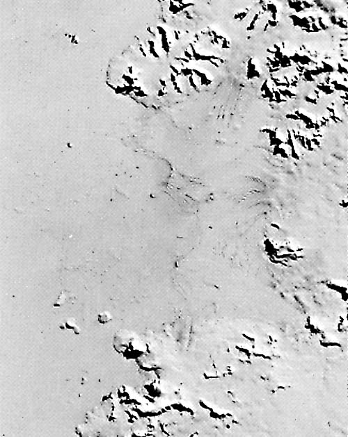
The Wordie Ice Shelf on the southwest side of the Antarctic Peninsula has experienced a major retreat since the late 1940s. According to Doake (1982), who analyzed two successive Landsat images of the Wordie Ice Shelf acquired in 1974 and 1979 (Figure G-2.3), the ice front retreated up to 7 km during this interval, and the ice shelf was reduced in area by 250 km2 . Details of crevasses and other surface features on the shelf appear in this enlargement of a part of this 1979 Landsat image. NOAA-6 AVHRR, Ch. 2, Orbit 7165, 13:42:15 UT, November 12, 1980.
Continue to Plate G-3| Chapter 9 Table of Contents.| Return to Home Page| Complete Table of Contents|