 |
 |
|---|---|
| Plate G-3 | Map |
|
|
|---|---|
| Plate G-3 | Map |
An ice stream is defined as "part of an ice sheet in which the ice flows more rapidly (than) and not necessarily in the same direction as the surrounding ice. The margins are sometimes clearly marked by a change in direction of the surface slope, but may be indistinct" (Armstrong et al 1973). Bates and Jackson (1980) add the following to this definition: "usually flowing to the ocean or to an ice shelf and not constrained by exposed rock." The following discussion restricts the definition to apply only to well-defined, fast-flowing streams of ice within a larger ice sheet or ice cap.
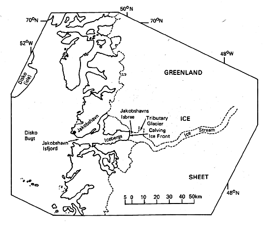
Although large ice caps can have ice streams associated with outlet glaciers, ice streams are most commonly found in ice sheets. In Antarctica, ice streams are the primary sources of ice for the large ice shelves, especially those that feed the Ross Ice Shelf (Figure G-3.1) and the Ronne and Filchner Ice Shelves (Hughes, 1977). Ice streams are also common on the west coast of Greenland (Mercer, 1975b).
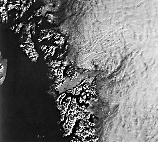
Plate G-3 is a Landsat image of Jakobshavns Isbrae (Sermeq kujatdelq, in Greenlandic), an important outlet glacier from the Greenland ice sheet on the west-central coast of Greenland. The terminus of Jakobshavns Isbrae is a prolific producer of icebergs that calve into Jakobshavns Isfjord (Stove et al., n.d.). Since 1850, the calving front of the outlet glacier has retreated approximately 25 km (Carbonnell, 1968; Bauer, 1968). Hughes (1983) notes that "Jacobshavn Glacier is the fastest surging ice stream at the present time." Its terminus moves at the rate of about 7 km/yr or about 19 m/day. Hughes (1983) states that Jakobshavns Isbrae drains about 10 percent of the Greenland ice sheet and accounts for 42 percent of the total volume of ice discharge from the western margin of the Greenland ice sheet (Carbonnell, 1968; Bauer, 1968). Hughes (1983) further notes that: "The most notable feature of the surface topography (of the ice sheet) is the large concave basin where the ice sheet funnels into Jacobshavn Glacier. A bedrock trough lies beneath this concave basin of converging flow, but has much less relief."
| Figure G-3.1 | Figure G-3.2 |
|---|---|
 |
 |
On the Landsat image, icebergs can be seen in Jakobshavns Isfjord, the production of which were the subject of an important study carried out with a sequential series of Landsat images (Stove et al., n.d.). Under this low Sun angle image, irregularities in the surface topography of the Greenland ice sheet are obvious, reflecting the presence of subglacial topographic relief. The ice stream is well defined from the 7-km wide terminus to about 100 km into the inland ice. Approximately 8 km up-glacier from the terminus, Jakobshavns Isbrae travels northwest through a 4-km wide subglacial valley in the bordering subglacial mountains. Just down-glacier from this exit point from the subglacial valley where Jakobshavns Isbrae broadens to about 7 km, a tributary glacier feeds in from the north. Approximately 15 km farther up-glacier from the exit point, the ice stream changes direction (from northwest flow to west-southwest flow), and a sinuous path can be traced for another 80 km to the east-northeast in the inland ice. It is probable that the Jakobshavns ice stream is following a sinuous preglacial valley for at least 100 km. The distance from the outer coast of Greenland, at the western end Jakobshavns Isfjord, to the head of the Jakobshavns ice stream is about 150 km.
This 150-km long path of Jakobshavns Isbrae is comparable to the length of the longest nearly straight fjord in Greenland, Søndre Strømfjord (see Plate G-14). It is concluded that Jakobshavns Isbrae flows in a subglacial valley that, if ice cover were removed, would be almost identical to Søndre Strømfjord. Such comparisons show that ice streams are the dominant erosional agent in the creation of the fjord landform, especially in its inland parts.
| Figure G-3.3 |
|---|
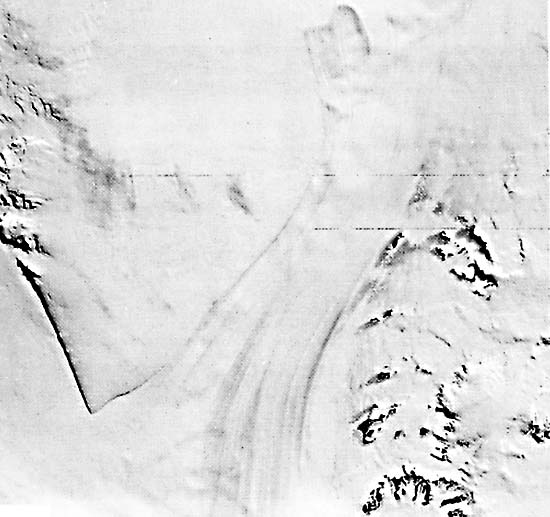 |
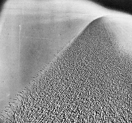
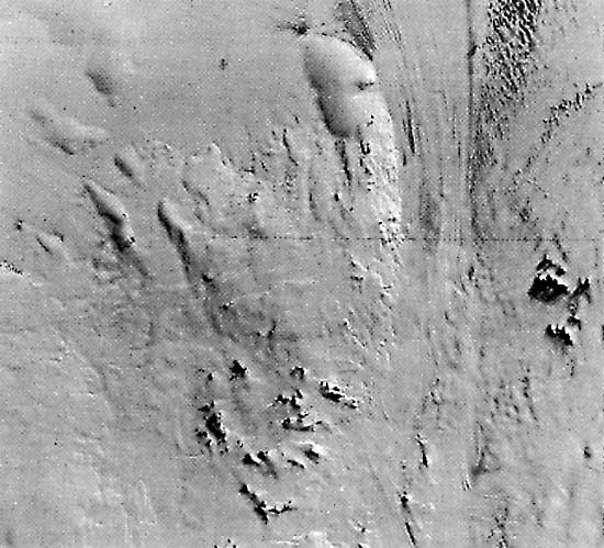
As noted earlier, ice streams are important sources of ice for ice shelves in Antarctica. The index map of the Ross Ice Shelf, Antarctica (Plate G-2), shows five ice streams on its eastern margin. Figure G-3.1 is an oblique aerial photograph of the northern edge of Ice Stream "B" on the western margin of the Ross Ice Shelf, Antarctica (Plate G-2, index map). Note the abrupt difference in flow between the heavily crevassed, more rapidly moving ice of the ice stream on the right and the noncrevassed, slowly moving ice of the ice shelf on the left. Figure G-3.2 is a Landsat image of the upper part of the Jutulstraumen Glacier, an ice stream in Queen Maud Land, East Antarctica. The Jutulstraumen Glacier flows north (toward top of image) onto the Fimbul Ice Shelf through a subglacial trough between the Sverdrup Mountains on the east and the Ahlmann Ridge on the west. Figure G-3.3 is a Landsat image of the mouth of the Slessor Glacier, where the ice stream enters the east side of the Filchner Ice Shelf, East Antarctica, between the Shackleton Range on the south (bottom right) and Parry Point (angular promontory on the left), the southwestern extension of the Theron Mountains on the north. Landsat 22087-14293-7, October 9, 1980.
Continue to Plate G-4| Chapter 9 Table of Contents.| Return to Home Page| Complete Table of Contents|