 |
 |
|---|---|
| Plate G-4 | Map |
|
|
|---|---|
| Plate G-4 | Map |
An ice field is defined as "an extensive mass of land ice covering a mountain region, consisting of many interconnected alpine and other types of glaciers, covering all but the highest peaks and ridges" (Bates and Jackson, 1980). The distinction between an ice cap (Plate G-5) and an ice field (Plate G-4) is the degree of burial of the landscape. Ice fields, for example, are common in the coastal mountain ranges of Alaska, where extensive masses of glacier ice partially cover the rugged mountain landscape and numerous outlet glaciers extend down-valley to the interior or coastal lowlands (Plate G-7). On the other hand, ice caps completely bury the underlying topography, although occasional nunataks may protrude through the ice cover, generally in the thinner marginal areas of the ice cap.
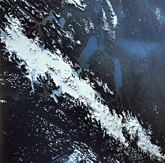
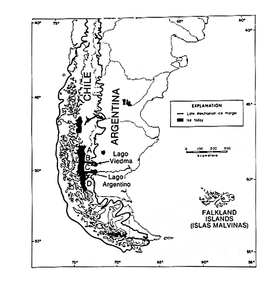
Ice fields tend to have long axes that extend along the crestal areas of mountain ranges; ice caps tend to be more circular or slightly elliptical. One of the classic ice fields on our planet is the Southern Patagonian ice field in the southern Andes of South America. It extends for about 300 km along the mountain divide and gives birth to numerous outlet glaciers (Mercer, 1967). The Southern Patagonian ice field is the principal remnant of a much larger ice sheet (large ice cap) that extended over a distance of about 2100 km and averaged about 250 km wide. The index map of the area shows the estimated extent of the Late Wisconsinan ice margins south of latitude 36° in southern South America. The largest black area is the present Southern Patagonian ice field shown in Plate G-4 (from Hollin and Schilling, 1981).
| Figure G-4.1 | Figure G-4.2 |
|---|---|
 |
 |
The ice fields and other glaciers of southern South America, especially those that are situated in the region between 46° and 56°S latitude, are not very well known. Access is difficult from the west; fierce storms are characteristic of the region, and only limited mapping has been accomplished. The long periods of overcast skies make the acquisition of aerial and satellite photographs or images that are suitable for mapping difficult and costly. Even during the 14 years of the Landsat program, comprehensive coverage of the glacierized areas south of about 50°S latitude is still lacking. Mercer (1967, pp. 136-137) described the Southern Patagonian ice field from available maps and his own observations:
"The southern Patagonian icefield is 360 km long and extends through about three degrees of latitude from 48°15´S to 51°20´S. Its greatest width between glacier termini is 90 km in latitude 48°50´S., but for much of its length it averages about 40 km. Outlet glaciers reach sea level in the fjords on the western side, many of which are choked with floating ice. On the east the largest glaciers calve into piedmont lakes at 185 m to 285 m above sea level."
Plate G-4 is an oblique color satellite photograph that provides the first complete coverage of most of the Southern Patagonian ice field, which sits astride the Andes Mountains along the Chile/Argentina border in southern South America. Numerous outlet glaciers with prominent medial moraines extend into fjords on the west and lakes on the east. Many lakes occupy valleys occupied by valley glaciers when the ice cover in the region expanded during the Pleistocene. The Plate photograph was acquired on March 10, 1978, by Soviet cosmonauts, G. M. Grechko and Yu. V. Romanenko, from the Salyut-6 spacecraft, as part of a series of glaciological research experiments designed by Vladimir M. Kotlyakov, a glaciologist with the Institute of Geography, Academy of Sciences of the U.S.S.R., in Moscow. This is one of 40 photographs taken of the ice fields and other glaciers in southern South America, several of which were analyzed in a paper by Desinov et al. (1980).
| Figure G-4.3 |
|---|
 |
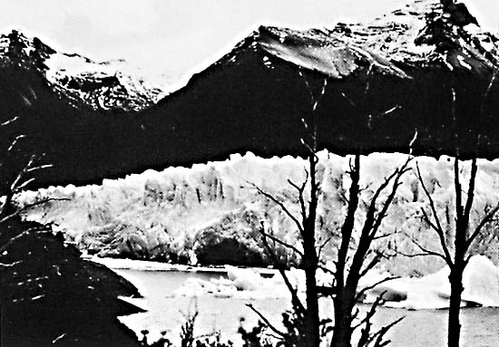
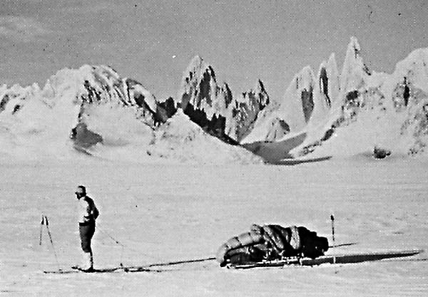
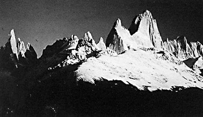
On the east side of this ice field, several outlet glaciers terminate in freshwater lakes: O´Higgins Glacier (A) in Lago O´Higgins, Viedma Glacier (B) in Lago Viedma, and Upsala Glacier (C) and Moreno Glacier (D) in Lago Argentino. Moreno Glacier has a history of surges across Canal de los Témpanos, an arm of Lago Argentino, which block the connection with another lake arm to the east (Brazo Rico). This produces flooding along the shore of Brazo Rico until the ice dam fails and the lake drains into Lago Argentino. Figure G-4.1 is a view in late October 1981 looking across Canal de los Témpanos and showing the terminus of the Moreno Glacier, Argentina, an outlet glacier on the east side of the Southern Patagonian Ice Field, after it has overridden the opposite shore. The ice dam closes off the connection between Canal de los Témpanos (foreground) and Brazo Rico (out of photograph to the left). The terminus is heavily crevassed and icebergs have calved from the vertical edge. The dark feature is probably the mouth of a tunnel formed by a subglacial stream. Figure G-4.2 is a view from the surface of the Southern Patagonian Ice Field looking east toward the western side of the Fitz Roy/Torre massif, with Cerro Fitz Roy (3441 m) on the left and the spire of Cerro Torre (3128 m) on the right (see also Figure 9-19).
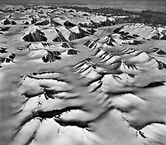
Figure G-4.3 is an oblique aerial photograph of an ice field in the Victoria and Albert Mountains on the eastern part of Ellesmere Island in the Queen Elizabeth Islands area. Meltponds are visible on the prominent outlet glacier in the right background. Numerous nunataks, cirques, arêtes, and horns are visible throughout the ice field. The glacially sculptured landscape is now partially submerged by a more continuous cover of ice. The Kane Basin and Greenland are faintly visible in the distant background. Salyut 6 Photograph, March 10, 1973.
Continue to Plate G-5| Chapter 9 Table of Contents.| Return to Home Page| Complete Table of Contents|