 |
 |
|---|---|
| Plate G-5 | Map |
|
|
|---|---|
| Plate G-5 | Map |
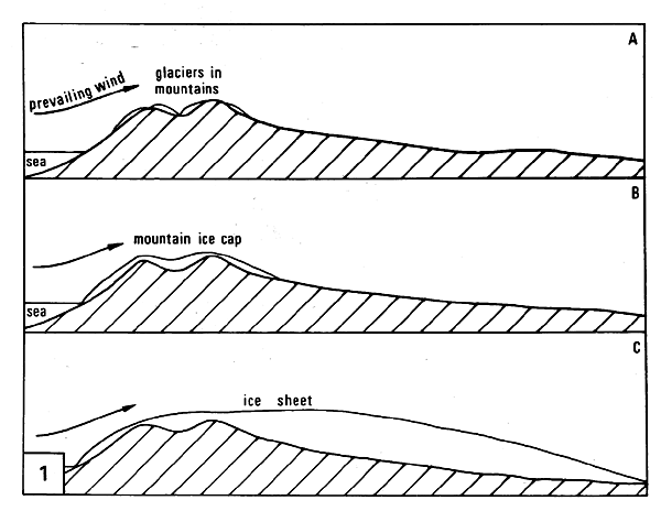
An ice cap is defined as "a dome-shaped glacier usually covering a highland area. Ice caps are considerably smaller in extent than ice sheets" (Armstrong et al., 1973). Armstrong et al. use a cutoff of 50 000 km2 to differentiate between ice sheets and ice caps. Figure G-5.1 (from Price, 1973) shows the evolution of isolated glaciers in a mountainous area, through development of a more extensive ice cap, to a large ice sheet.
Ice caps can be either small isolated domal masses of ice, such as the tiny (4.0 km2) ice cap on the volcano Ok in Iceland, quasi-circular or elongated composite masses of ice, such as Vatnajökull (8300 km2) in southeastern Iceland (Plate G-6), or more elongated masses of ice extending for 100 km or more.
An ice cap may have a smooth margin, such as the Barnes ice cap on Baffin Island in Canada seen in this Plate, or more typically, it may have various lobes that protrude into areas of low relief, called outlet glaciers, that extend down valleys from the main ice cap, such as the Vatnajökull ice cap in Iceland (Plate G-6).
| Figure G-5.1 | FigG-5.2 |
|---|---|
 |
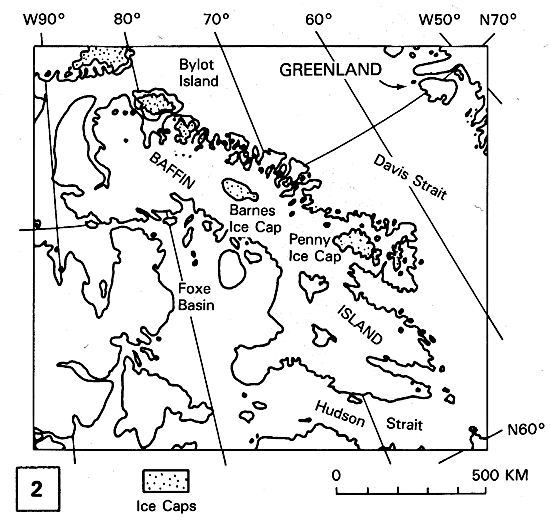 |
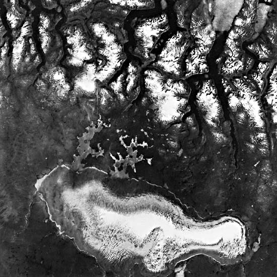
Plate G-5 is a Landsat image of the Barnes Ice Cap on the central part of Baffin Island, Northwest Territories, Canada (American Geographical Society Glacier Studies, 1975a). The Barnes Ice Cap lies 300 km southeast of the cirque glaciers on Bylot Island, which are discussed later in this section (Plate G-8), and 300 km northwest of the Penny Ice Cap in the southeastern part of Baffin Island. Figure G-5.2 is a locator map for the glaciers of Baffin Island. According to Mercer (1975a, p. 685), "Glaciers occur in the mountains along the north and east coasts of the island (Baffin Island), and less extensively in the interior. There are two large ice caps, Barnes on low ground in the interior of the island, and (the) Penny on the eastern mountains . . . . Other areas have extensive glaciers, some of which are small ice caps." Mercer (1975a), who uses Bird (1967) as a source, notes that Baffin Island has 36 830 km2 covered by glaciers, about 7 percent of the island, and the Barnes and Penny Ice Caps are about equal in size, 5935 and 5960 km2, respectively.
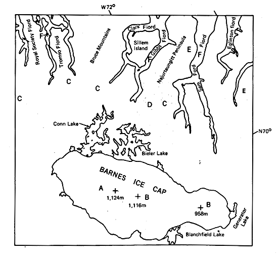
Mercer (1975a, p. 694) provides a description of the ice cap: "The Barnes Ice Cap is near the middle of Baffin Island, with its center at 70°10´N and 73°30´W. It occupies rolling country of relatively low relief, west of the main watershed of the island, with altitudes of up to nearly 550 m. The ice cap covers 5935 sq. km., and its main axis is 150 km. long, approximately parallel to the northwesterly trend of the island. It rests on the slightly dissected plateau of central Baffin Island. The broad, gently-sloping summit area of the main ice cap reaches 1130 m., and the lobe at the south end reaches 975 m. The gradients are nowhere steep, except locally at the margin. In the accumulation season, the ice surface is smooth and undulating; but at the height of summer, stream channels area meter deep in the crest area and 9 m. deep near the margins."
| Figure G-5.3 |
|---|
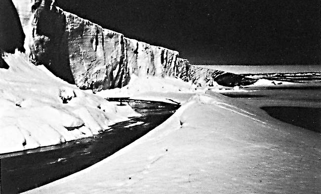 |
On the Landsat image of the Barnes Ice Cap, numerous stream channels can be seen radiating away from the crestal area (divide) of the ice cap (A). Most of the ice cap has shed the accumulated snow from the previous winter, although either residual snowpack or a fresh snowfall covers a limited area at the highest elevations (B). Small ice caps (C), outlet glaciers (D), and numerous small cirque glaciers (E) can be seen to the east and northeast of the Barnes Ice Cap in the mountains that border Baffin Bay, which lies farther to the east just beyond the edge of the image. Well-developed fjords (F) have been eroded in these mountains by the expanded glaciation of the region during the Wisconsinan and earlier advances of glaciers. The Barnes Ice Cap also calves into several proglacial lakes along its terminus, especially into Corm and Bieler Lakes on the northeast and Generator (Figure G-5.3) and Blanchfield Lakes on the southeast and south, respectively. Figure G-5.3 is a view of the steep ice front on the southeast margin of the Barnes Ice Cap, where it terminates in Generator Lake. These lakes still have an ice cover on August 7, 1973.
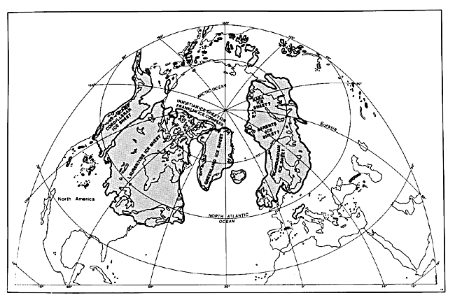
Although not all Quaternary geologists agree with Mayewski et al. (1981), the latter consider the glaciers of Baffin Island to be remnants of an extensive ice sheet that covered much of the northern part of North America (see Figure 9-l). As the Laurentide Ice Sheet waned during the last stages of the Wisconsinan, it broke up into large isolated ice caps, some of which persisted into the Holocene. Landsat 1380-16182-7, August 7, 1973.
Continue to Plate G-6| Chapter 9 Table of Contents.| Return to Home Page| Complete Table of Contents|