 |
 |
|---|---|
| Figures 5.1c and 5.1d | |
 |
 |
James M. Coleman, Harry H. Roberts, and Oscar K. Huh*
Since ancient times, river deltas have been of fundamental importance to civilization. Owing to their early significance as agricultural lands, deltas received considerable attention from ancient scholars such as Homer, Plato, and Aristotle. The term ŇdeltaÓ was first applied by the Greek historian Herodotus in approximately 450 B.C. to the triangular deposit of riverborne sediments at the mouth of the Nile River in Egypt. Deltas in general, as for the Nile in particular, have been areas of special importance to civilization as sites of habitation, agricultural activity, navigation, and fishing. These coastal lowland areas, however, have special problems as well. They are subject to severe catastrophes, including floods from the landward side and sealevel surges, extreme wave erosion, and storm winds from the seaward side. They are major sedimentary depocenters, the surfaces of which are highly sensitive to changes in climate, marine conditions, fluvial hydrology, foliage development, and tectonism. In modern times, they have taken on new importance. Subsurface deltaic facies have played a paramount role in accommodating the world's energy needs; ancient deltaic sediments have provided source beds and reservoirs for a large percentage of known petroleum reserves.
A delta can be defined as a coastalsedimentary deposit with both subaerial and subaqueous expression that has beenderived from riverborne sediments deposited in and at the edge of a standing bodyof water (mainly oceans but also lakes). A delta is one component of a riversystem which, in totality, includes the drainage basin, the alluvial plain, the subaerial delta plain, and the subaqueous delta/abyssal fan of the receiving basin. Included are those riverborne sediments molded into marine deposits byagents such as waves, currents, and tides of the receiving (marine) basins. Deltas are complex and fragile assemblages of coastal landforms that may include distributary channels, estuaries, river-mouth bars, subaerial/subaqueous levees,interdistributary bays, tidal flats, tidal ridges, beaches, dunes, swamps,marshes, and evaporite flats.
The forms of modern-day deltas vary considerably around the globe and exist in a wide variety of geotectonic, geomorphic, oceanographic, and climatic settings. Delta development is governed by: (1) climatic effects on water/sediment yield and organic/evaporite sediment availability, (2) seasonal and interannual variability in water discharge regime, (3) variations in sediment yield, especially proportions of sand and fine-grained sediment, (4) river-mouth processes controlled by inertial, buoyant, and frictional forces, (5) balance between wave-power regime (weak to dominant) and fluvial seaward extension of deposits, (6) tidal processes creating multiple channels, (7) wind-driven processes responsible for shallow-water currents and dune formation, (8) effects of nearshore currents, deep-water oceanic currents, and density currents, (9) influence of coastal configuration, particularly shelf slope and topography, (10) receiving basin geometry, and (11) tectonics of receiving basin (Coleman, 1976). Tidal-, wave-, or river-dominant processes impress shore-normal channels, smooth contours of barrier islands, or the digitate/lobate river distributary forms, respectively. The possible combinations are infinite, and each delta is a separate case but with analogous components.
Great deltas form at the mouths of great rivers, and these have been observed to debouch into the sea from cratonic areas of the continental plates (Potter, 1978). In terms of plate tectonic elements, the great deltas of the globe occur predominantly along trailing-edge coasts or marginal seacoasts (Inman and Nordstrom, 1971).
Deltas are regions of rapid and significant change in their surface form. Fundamental scientific problems are encountered in determining which changes are most influential in the steady-state evolution of deltas and what are the process changes resulting from tectonism, important climate shifts, or human activity. How, for example, will these sedimentary systems respond to fluctuations of climate, hydrology, and oceanography under conditions of ice age renewal or global warming? Intellectually, these and other questions will remain major challenges to present and future scientists, even though they will be armed with the timely results of superb new technological and conceptual advances. Pragmatically, the continuous demand for hydrocarbon fuels, agricultural land, and renewable resources will drive expanding human activity in deltas throughout the world. Efforts to explore, understand, manage, and exploit these complex coastal sedimentation sites will most certainly be maintained and will likely intensify in the coming years.
Imagery from spaceborne sensors is even now being used to monitor, analyze, and understand these important sedimentary deposystems. The prime advantage of space imagery to the study of deltas is that entire deltas can be examined in single scenes in context with their surroundings. Many deltas just about fit within a full Landsat image. This match in scales is one reason why deltas warrant a separate chapter (placed naturally between Fluvial and Coastal Landforms) in this book.
|
|
|---|---|
| Figures 5.1c and 5.1d | |
|
|
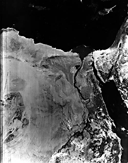
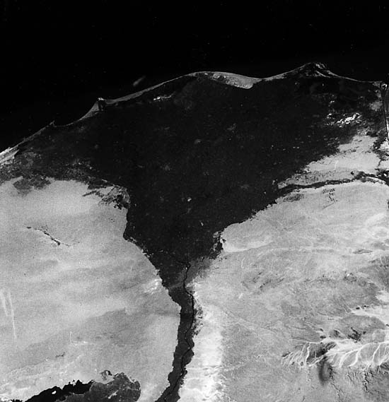
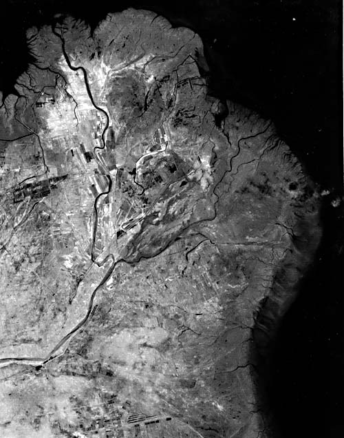
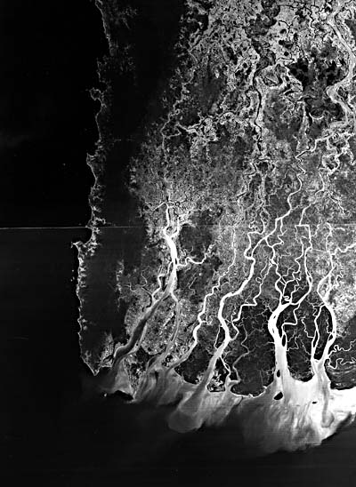
Figure 5.1. Images of several major deltas as viewed from space: (a) Defense Meteorological satellite image of the Nile River from a point near Kerma, in the Sudan, through all of Egypt to its delta termination on the Medeterranean Sea. Length of image covers about 1900 km. (b) Near-vertical photograph of the Nile Delta and surrounding desert, taken by hand-held Hasselblad camera during the STS&^#45;4 Shuttle mission in summer 1982. (c) Part of a Landsat image showing the Huang He (Yellow River) delta. (d) The delta of the Irrawaddy River in Burma as imaged in a two-frame Landsat mosaic, 3026-03235-5 and 30263- 03242-5, November 23, 1978.
The montage of delta images in Figure 5-1 illustrates both this advantage of the small-scale satellite remotely sensed images and some major variations among deltas. The classical Nile River delta is shown at two scales inFigure 5.1a and Figure 5-1b. In 5-la, visible-IR range (0.4 to 1.1 mm) imagery obtained by a Defense Meteorological Satellite captures the entire river delta, the upstream drainage basin, and regional geomorphic features in eastern Egypt. The once- to twice- daily repetition rate in coverage is invaluable in monitoring large-area changes across the delta region, but the low spatial resolution (0.6 km) seriously limits this and other meteorological satellite systems (e.g., NOAA orbital satellites at greater than l-km resolution and geostationary satellites at 2 to 8 km) for geomorphic observations. The most critical deficiency is that the essential relatively fine-scale geomorphic detail is missing. Figure 5-lb is a photograph taken by astronauts Mattingly and Hartsfield during the STS-4 Shuttle mission in summer 1982 using a 70-mm hand-held camera. Images at scales and resolutions similar to this (e.g., the Landsat MSS) are necessary for effective studies of the world´s deltas and are used predominantly in this chapter. Figure 5-1c and Figure 5.1d are Landsat images of the Huang He (Yellow River) and the Irrawaddy River deltas. Note the lobate distributary mouths of the Huang He delta and the well- developed bell-shaped channel mouths in the Irrawaddy delta. The differences are due to the enormous silt load carried in a microtidal marine embayment in the Yellow Sea versus the modest sediment load introduced into a mesotidal marine basin off Burma.
Even better high-resolution, morefrequent multispectral, and, where possible, all-weather imagery is needed for future studies in deltaic environments. The primary value of such imagery is in direct observation of active processes through a range of time and space scales. Such time- lapse monitoring of environment will detect active versus dormant processes, as well as continuous versus discrete processes, and will provide synoptic detail on the progress and extent of catastrophic changes (as after a hurricane). Synoptic data are particularly valuable in providing plan-view observations that aid in the deployment of systems/personnel for making critical, much more detailed data gathering. Satellite-borne sensors can facilitate observations along the entire river system, from the upper drainage basin down to sea level and the offshore mudstreams. Certain types of imagery, such as that obtained by the Synthetic Aperture Radar (SAR) carried on the Shuttle, the visible-near-IR Landsat Multispectral Scanner and Thematic Mapper, the NOAA Advanced Very High Resolution Radiometer (AVHRR), and the Nimbus Coastal-Zone Color Scanner (CZCS), offer a range of capabilities. They can be analyzed for information about geomorphic changes in delta shapes, vegetation conditions on the subaerial surfaces, primary productivity (plankton blooms) on the shelf, and offshore mudstreams in surface/near- surface waters of the receiving basin. Indirect evidence on circulation in the waters adjacent to the delta is available from analysis of turbid and thermal discharge plumes.
Satellite imagery has already proved beneficial in recognizing similarities and differences in modern world deltas in that, for the first time, a wide variety of delta types has been covered repeatedly in time by the same sensor systems. The uniformity of data scale, quality, and characteristics offers a premium opportunity for change detection, so essential to scientific study of deltaic processes. However, change occurs on many time scales and is sensitive to many causes. Sorting out these factors provides an awesome scientific challenge.
The collection of images discussed in this chapter covers not only the variety of landforms that exist in deltas worldwide, but also attempts to show the variability in the environmental basin settings in some modern deltas. Cloud cover, delta scale, and image availability did not allow all types of deltas to be included in this review, but the 15 Plates treated here will portray most of the major variations that exist. The following listing of the deltas covered presents a ŇthumbnailÓ synopsis of their environmental settings and characteristics:
Continue to Plate D-1| Chapter 5 table of Contents| Return to Home Page| Complete Table of Contents|